
We planned a different ride than what we actually did. But what we present here is actually rideable. Sometimes what you see on the map is so much different than the reality. And this is the greatest advantage if somebody, like us, really checked the whole proposed route. Some of the pictures below shows the trouble we encountered.
There are many places in Litoměřice where you can start your ride. Parking in the main square is not recommended as it is the most expensive option (50 Kč per hour). But you should see the square, so we map it from there. There is also a very nice place “Kafe doma” where you can stop for a good lunch or just a coffee. It is by the way, the first certified Feng Shui kavárna.
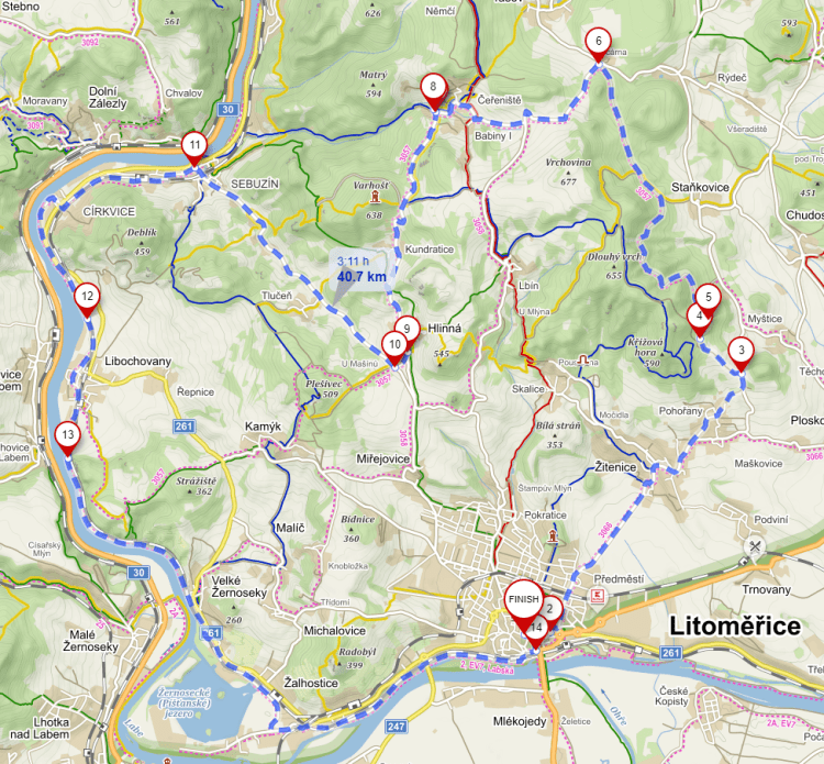
From the town to point 3 you will be partly on the normal road, which could be quite busy. We did not leave this road exactly at point 3, but about 100 m later where the map was showing the path to the left. And that was our first mistake of the day. After about 300 m uphill, the path disappeared into the forest. So we just decided (because we are quite stubborn) to push the bikes through the forest all the way to point 5. Luckily, the electric bikes have the “walk” function… After joining the forest road at point 5 the ride was uneventful up to point 7. There we tried to use the blue tourist marked path down to the river Labe and from there to follow the regular bike path. And that was the second mistake. As you can see from the pictures below, our stubbornness was not a match for this path. The only part of this attempt was the visit to the protected tree at point 8, where the local “artist” created funny statue of rabbit with the real cell phone…
So, as an alternative way to get to Sebuzín to join the bike path, we used the regular road through Kundratice and Hlinná. The part from point 10 to 11 is a fast 4 km downhill ride on quite a busy road, so pay attention to the cars there. From point 11 back to Litoměřice you will be riding on one of the major European bike path with mostly quite nicely maintained surface. After point 13 you will be passing through “Porta Bohemica” (gateway to Bohemia), stone formation through which the river Labe is cutting its path through České středohoří (Central Bohemian Highlands).
https://en.mapy.cz/s/legazuvuza, 41 km, 628 m elevation gain. To see this ride in context, check our interactive maps.


One thought on “Litoměřice”