Malé Karpaty, Slovakia

It was surprising to find out that miles and miles of bike paths are available just five minutes from the Bratislava center. As we quickly realized, it is important to pay attention to the traffic signs and do not depend entirely on the phone navigation – yes, you can drive your car pretty high in this protected area of Malé Karpaty (Little Carpathians), but you must have a special permit… So, it is advisable to find a spot at the parking lot where we started our E-bike trip.

Another important thing is not to run out of the battery in your phone. There is so many biking trails that it is very easy to pick the one which would lead you away from your destination…

Not many comments are necessary here – at point 3 you should trust the mapping app, even though it looks like the trail is disappearing in the fallen trees. But there is a path around them… BUT – path from 7 to 8 is a trail from hell. Steep uphill through ruts made by heavy machinery, totally nonbikeable. However, if you want to visit the well known pilgrimage site Marianka, you either suffer the 7 to 8 torture, or you may backtrack to Malinsky vrch by following the bike route along Malinsky potok (stream). After point 9 you will finish your E-bike ride on a long ride downhill.

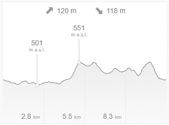
https://en.mapy.cz/s/bupusazeto 29.6 km, 666 m elevation gain. To see this E-bike trip in context, check our interactive maps.

Želízy – Kokořínsko

This is the E-bike ride for people who already know Kokořínsko and want to see it from a little different perspective. If it is your first visit, pick one of several rides we already reported here or especially the long one described here.

We started on a parking lot operated by Mrs. Šimůnková, just because she was a delight to chat with. She works a paid private parking lot, but you don’t have to pay for parking in Želízy, there is a number of other opportunities to leave your car.

Up to a point 5 you will be riding along a border of protected area Kokořínsko. The highlights of this part are a view of electric power station Mělník and the chapel dedicated to the memory of count Clary who was murdered at that spot in the year 1720 (point 4). After a long ride down from Brocno (5) to Chudolazy (6), you may have a lunch at the restaurant “U červených vrat“, where they will give you discount if you mention this blog. You can actually use this place as a starting point to explore Kokořínsko – they will give you a good deal on the room here.

Ride from 9 to 10 is probably the most challenging – the path was obviously used by heavy machinery. At point 10 you will turn onto a regular road downhill going between impressive sandstone formations. At point 15 you can just follow the regular road to point 17, but to make it more interesting go to point 16 and turn left to follow almost invisible little path downhill to point 17. You will be riding between nicely maintained “chalupy” – weekend cottages of the town people.

When you arrive to point 18, your uphill E-bike ride is over. From here it is downhill between stone formations on both sides all the way to your car. Besides naturally formed sandstone you may explore the places where people lived or built houses by carving them out of stone. You can also visit the famous carvings of Devil’s heads (Čertovy hlavy) – a short walk from the parking lot.

https://en.mapy.cz/s/penunezosa 35 km, 495 m elevation gain. To see this E-bike trip in context, check our interactive maps.

Keszthely, Hungary

So, finally we left the boundaries of Czechia and try other countries of the European Union – Slovakia and Hungary. Our excuse to go to Hungary was the visit of Hévíz, the town with the largest biologically active natural thermal lake in the world. And lake Balaton, the largest lake in Central Europe. It was tempting to ride around Balaton, but it would take more than 250 km, so we just took a peak at it and made  an E-bike trip starting from beach town of Keszthely.

We found a convenient parking lot close to the center and went down to the lake. The water was still cold, so we continued along the shore and through the town to the foresty hills. Part of the ride was on an old asphalt road, much worse than normal forest roads that we are used to ride. At point 6 we were planning to follow the green tourist mark to point 9, but after less than 1 km we had to turn back since the path was filled with fallen trees. We therefore followed the road to point 7 – Várvolgy, where we foung an excellent restaurant Szt. Domonkos. They served us much needed drinks and we tried their “štrůdl” which looked nothing like strudel made in Czechia, but which tasted super good. By the way, if you would visit this place and tell them that you read about it in our blog, they will give you a hefty discount!

At point 9 you will turn from the main road to the forest and you will have to be very careful, since the path is really broken with heavy machinery using it in the rainy weather. At point 10 you can turn to the left and join our route at point 13, but then you will miss the Dinopark at Rezi… (see pictures below). In Keszthely you will finish your E-bike trip through the Kossuth Lajos Utca, the main “corso” of this spa town.

https://en.mapy.cz/s/latojugote 36km, 450m elevation gain. To see this E-bike trip in context, check our interactive maps.

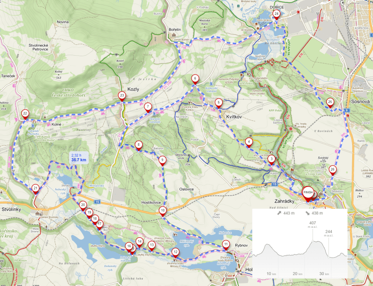
Peklo, Zahrádky u České Lípy

We call this E-bike ride “Around Hell” because it will lead you around natural preserve called Peklo, which in Czech means Hell. If you will have more time, you can walk through that narrow valley following the red mark as we did earlier. The best time to visit this location is during March when it is full of blooming “bledule” (Spring Snowflake, Leucojum vernum). It is one of the famous spots for this natural phenomenon – the other one being at Písty, close to Budyně nad Ohří, which we described earlier.  

Entrance to this valley is strictly forbidden for bikers, so we did not visit the blooming fields this time. We started from a small parking lot in Zahrádky, where it may be hard to find a place during the weekend. Little more than half of the ride is on nice forest roads, but unfortunately this time we were not able to avoid the asphalt roads completely. The area of Zahrádky is known for black and white log houses, which you can find all over the place.

You will see eight ponds of different sizes, and in summer you can probably take a swim in couple of them. This time of the year we saw only a lot of fishermen. And quite surprisingly, we saw even a fish in boots! It was only a statute, but still… Make sure that you don’t miss it at point 15. However, the biggest attraction is the old stone bridge at point 14 and ruins of the castle Milčany at point 12. The part around the bridge at 14 is not rideable and you should be careful to avoid unpleasant fall. If you decide to follow marked bike route 3088 after point 12 instead a little more challenging red tourist mark, you will miss the nicest part of the ride 12 to 20. 

From 21 to 24 you will be on a very little frequented asphalt road with a nice downhill ride from Bořetín to Dubice. From 24 to 25 you will pass through the sandstone formations on the left and you will finish the E-bike trip on an asphalt road. But you should pay attention for signs written on the road “ŽÁBY” – it means that frogs may be crossing the road in tropes and you should not kill any (they are very slippery…). And back in Zahrádky you can visit “Hospůdka U Zámku” restaurant where they may give you 10% discount if you mention our blog.

At point 10 you may stop at something you may not have seen yet – the second hand shop “Sekáček v lese” operated by Mrs. Hrošková – she may not be there, but pick anything you like and leave Kč 20 per piece of clothing in a little box. You will not be able to find better deal anywhere in the world! 

https://en.mapy.cz/s/hetorelotu 36 km, 440 m elevation gain. To see this E-bike trip in context, check our interactive maps.

Nový Knín

Not much went according to the plan on this E-bike trip. Not even one km into the trip Polly tore the tire and punctured the inner tube. Fortunately we had a spare and luckily the tire held for the rest of the trip. Then we got lost and had to walk along a freshly plowed field and through a non-rideable forest uphill. Again, the planned route was not rideable, so we had to improvise and find better way for you. But close to the end we found our luck at the place where the map said that there is only a ford. There was actually a primitive but solid pedestrian bridge over the quite wild stream of Kocába and we were happy to not get wet. We submitted several changes to Mapy.cz which were immediately accepted and will be seen in the next maps update.

You can start at the small parking lot close to Kocába stream, or on the main square of Nový Knín. As soon as you leave the village, you will realize that this trip is planned for mountain bikes only. The part to point 2 is quite a challenging uphill struggle, where you have to choose your path super carefully. We lost the way at the point 3 and rejoined the route between point 4 and 5, so we cannot comment on anything between 3 and 4. At point 8 do not even think about following the green tourist mark – it ends in the middle of very spiky shrubs and the path completely disappears. Just cross the meadow to point 10. There you will see the sign “Do not enter the forest”, so do not enter the forest, stay on the path… From point 12 we planned to follow a red tourist mark, but that path is totally unpassable due to downed trees. Obviously, somebody is working on cleaning the path, so maybe in couple of weeks it would be OK to follow this path to point 14 in the village of Buš. If you decide to try the red mark, you will miss the Ranch in Buš (Ranč v Buši) at point 13, where you can try your skills in horseback riding (but only if you have your horse staying there).

Just in case you are hungry at this point, there is an excellent restaurant called U Váňů in Buš (if you mention our blog they may give you 10% discount) – but only Wednesday to Sunday. If you need to charge your bike battery or your cell phone you can do that any day of the week just next to the pub. You can also admire the art piece Vltava, or find the geocache vodník.

After passing through village of Slapy, you can decide to try the Trailpark Slapy to test your riding skills. We were tempted, but with the excuse of the tire situation (see above), we did not go for it. Next time we will! Just before the point 26 you may be tempted to take a shortcut straight through the forest, if the road is blocked by a huge truck, but don’t do it, or you may end up walking through the deep mud like us.

In Malá Lečice you can follow the road to point 31, or go uphill to see the statue of goddess Diana and enjoy a scary ride downhill 30 to 31. Do not miss the waterfall in Lečice – it is very nice this time of the year with a good flow from the Kocába. At point 37 we were lucky to find a primitive metal bridge to cross the stream and followed the water back to the start of our E-bike trip.

https://en.mapy.cz/s/kudofuzoco 31 km, 670 m elevation gain. To see this E-bike trip in context, check our interactive maps.

Buštěhrad, Lidice, Kladno

Very uneventful ride on a nice spring day. Parking was easy next to the playground on a quiet street in Buštěhrad, a nice small town with quite a rich history. If you have never been to Lidice, you should visit the memorial to the victims of the terror of the WWII, especially the children’s memorial which is downhill and left from the point 3. This memorial should remind everybody that the similar war crimes are committed right now by Putin’s army not more than 1000 km away from Prague. If you don’t want to repeat the history of WWII, please, help Ukraine in any way you can!

At point 5 do not try to be smart and continue on the path on top of the wall, it ends with a fence. From point 6 you will be finally on pleasant forest roads basically all the way to point 18. And on the way you can pick up the geocaching series “Po stopách Jonathana” by paní Kadrnožková, or geocache dedicated to the history of totally delapidated and overgrown natural theater Barre.

At point 13 you can try the pumptrack Nad Oleškou. We did not try it as it was too wet and we did not feel like cleaning bikes from all the mud. From 14 to 15 you can just cross the road as pedestrians instead of taking the roundabout. At point 17 you can continue straight instead following our path downhill which is probably the only slightly challenging part of this trip. After turning right at the pond of Ota Pavel, named after one of Michal’s favorite Czech writers, be ready for a steep uphill from 21 to 22.

https://en.mapy.cz/s/fekebuzapo 34 km, 320 m elevation gain. To see this ride in context, check our interactive maps.

Natural Preserve Zámky – Winter walks

A short walk for winter weather. A sunny afternoon would be an ideal situation for this walk. You can start at a small parking lot in front of the animal cemetery if you arrive by car, or at point 5 (Zámky) if you arrive by bus. You can read about the animal cemetery or the scary cemetery just opposite to that in our previous blogs.

Do not miss viewpoints 2 and 9 and do not be surprised by walking on the edges of the slopes. You should be also prepared for a steep descent to point 5 and a sharp ascend from 6 to 7. From 6 to 10 you will be walking through natural preserve Zámky where you can imagine how nice it would be to be able to pitch your tent there and watch the sunset at the campfire but do not plan on doing that, it is strictly forbidden.

https://en.mapy.cz/s/hejabaselo


Přemyšlení

A rather short ride in Prague neighborhoods and along the Vltava River. (For learning about the Prague neighborhoods, check the video created by our friend, the famous video blogger Jen of Prague.) You can start at the parking in front of the Písecká brána, the gate from the medieval times’ fortification of Prague. This historical site was recently renovated and is now hosting a cozy coffee shop. After crossing Letná Park you may look at the historical merry-go-round at point 4, again very recently renovated by National Technical Museum, which is just across the street from there. Interesting note – this carousel was originally driven by children running under the platform and pushing this thing around. After five runs under they could ride the carousel on top. And there was a long line of kids to operate/ride this invention. Nowadays it is being pushed by boring electricity.

After crossing Vltava around point 7 you will endure a very steep climb up for about 1km. From 9 to 11 the path can be pretty muddy, especially from 10 to 11. Another muddy part is waiting for you between 16 and 17. After that, you will ride on a nice asphalt bike path along the river bank with several points where you can have a drink or a bratwurst.

https://en.mapy.cz/s/jelofojape 28km, 320 m elevation gain. To see this ride in context, check our interactive maps.

Mirošov, Brdy

This was one of the nicest rides in Brdy. Well, most of the rides in Brdy are pretty pleasant, even in winter. But sometimes you can get into tricky situations even here… We started in Mirošov and took a little detour through Dobřív, where you can visit the unique technical rarity – vodní hamr (water-powered hammer workshop). After crossing road 117 you will ride through Strašice, where a lot of my friends spent their mandatory military service years. If you want to experience the feeling of military service during the communist times in Czechoslovakia, you may look up the movie Tankový Prapor (Tank Batallion), which was shot very close to this location.

From point 4 almost up to point 11, you will be riding uphill on nice forest roads. You should not miss the look at the památný strom (veteran tree) at point 10. Very close to that tree is a very clever geocache – if you are not familiar with that game, you can find the rules here.

From point 11 you will be going basically downhill and the last part from Skořice will be on the regular road. If you would be hungry at this point, you may stop at the pub U Kozlerů, which we are happily recommending. If you show them this blog, they will give you a 10% discount on your bill. And they have draft Kofola, of course.

https://en.mapy.cz/s/dapapazove 43 km, 555 m elevation gain. To see this ride in context, check our interactive maps.

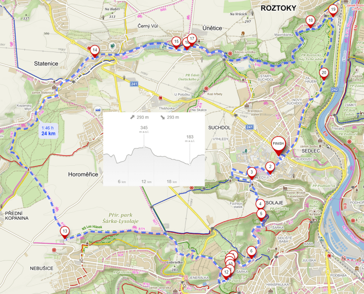
Únětice

An interesting short loop with a break for lunch at the Únětice brewery. We rode it earlier and we would not recommend this for the ride today with the fresh snow on the ground. Especially the part from 4 to 5 that was steep down and slippery already then… Rather walk your bike down unless you are a single-track rider – but even if you are, don’t do it since this is not a single track!

Otherwise, you will be riding through a lot of forests, which is quite unusual while being so close to Prague. Don’t forget to say your prayer at the statue of St. Juliane, stop for a beer in Únětice, and ride a little passage called “Kozí ocásek” (Goat’s tail) in that town. If you would ride with this map in better weather, you can climb up to Alšova vyhlídka just after Únětice. Don’t climb with your bike, just park it down there. Mikoláš Aleš was a famous Czech painter – you can see his graphics on several houses in Prague and he was one of the painters working on the decorations of the National Theatre.

https://en.mapy.cz/s/lubazekojo 24 km, 293 m elevation gain. To see this ride in context, check our interactive maps.

Kvilda Loop – Šumava


This was one of our favorite rides in Šumava. Starting from Kvilda, going through Modrava, along Modravský potok to the top of Šumava and along the border to Knížecí Pláně. Starting from the parking in Kvilda you can join the yellow tourist mark basically following the asphalt road. It is a much bumpier ride, but no competition with cars passing by. Unfortunately, the yellow mark was turning away from the road at the point where following it seemed too tricky. After joining asphalt, you enjoy the long ride down to Modrava. (If you did not bring your bike, you can rent one from Modrava’s rental shop, one of our supporters. They will have the E-bike for you, and if you mention our blog, you may expect a rental discount.) Just before you turn to ride uphill at point 2, you may have a beer at the restaurant “U tří sluk“. Riding along Modravský potok may entice you to sit down and meditate at its banks listening to its bubbly noises. Up to point 3, you may contemplate the fact that nature decided to come back with a bang – the forests around here were devastated by the invasion of bark beetle, but in the middle of the dead forest is already a very visible new generation of trees taking over the insect’s destruction.

If you need to cut your trip short, point 4 is an ideal place to make that decision and take a blue tourist mark back to Kvilda. But if you do that, you would miss the opportunity to visit a sample of an “iron curtain” at Bučina (point 6, see our earlier post) and after a nice long downhill ride have an excellent beer “Březí koza” at Knížecí Pláně. After that, a long ride through a dense forest will bring you back to Kvilda.

https://en.mapy.cz/s/nebecuvaku 39.2 km, 700 m elevation gain. To see this ride in context, check our interactive maps.

Šumava – Strážný


Another ride through German side of Šumava.  This time “halb und halb”, half on the Czech side, half in Germany. This time only a short path was really steep uphill but in the end a nice reward of a long ride downhill. A very short part of this trip is on the side of a busy highway – if you do not miss the turn onto an abandoned road at point 2. The part of this map is marked as “No entry for bikes”, but no sign like that exists in the reality and you can safely follow the red and later green tourist mark through point 3. At point 5 the map will try to lead you through the town of Philipsreuth, but you can avoid that and take a shortcut from 5 to 6 on the road. After point 7 you will be on the nice local and forest roads all the way back to Strážný. You may be surprised by the sharp change of the surface at point 8 and afterward with the steep climb to point 9.

At point 12 you will be wondering what the path on your left is – it is a track for roller-skaters. Unfortunately, we did not see anybody there… Another point worth stopping is 13, where you may see how the border with Germany looked during the existence of the “Iron curtain“. Lots of people lost their lives trying to cross it over the years back then. (At that time the popular jokes ran like this: Mother and son are looking at the fence and the boy says – “Mom, who lives behind this terrible fence?” And mom responds – “We are son, we are…”)

After point 13 you will enjoy the long ride down on a very smooth surface where you could easily go too fast, so, don’t. And at the point 15 you may stop at the refreshment point where you should try the beer “Březí koza” (Pregnant goat), which I consider the best in Šumava. And back at Strážný you can be again shopping for dwarfs and bird feeders…

https://en.mapy.cz/s/mufohafode 40.6 km, 720 m elevation gain. To see this ride in context, check our interactive maps.


Železná Ruda – Šumava

We have explored Šumava quite thoroughly (see our earlier blogs), but we never crossed to the German side. And, of course, it would not be Šumava but Bayerisher Wald. So, we had to do it. We started from Železná Ruda, the village just on the border with Germany, famous for the large population of beavers, (that are called a hidden gem here), working on modifying all streams around here. (Funny thing – if you search for “beavers Železná Ruda” on Google, our blog about the earlier ride here will come up.)

We started from the parking lot next to the house with a sundial that was very unique by the fact that it took into account the shift from the summer to normal time. (You just have to know which dial to look at at the proper time.)  After crossing the border you will be probably the only one on the bike for the whole trip, unlike on the Czech side of the border. On the other hand, you can definitely see without even looking at the map that you are on the German side, just by looking at the houses and their yards – everything is perfectly organized and cleaned… Unlike on the Czech side.

And your ride will be quite a lot uphill. After one of the longest uphill stretches (3 to 4), you may feel like Polly in the title picture and sit down for a bit. If you arrive at point 3 with only 30% of your battery, you may be in trouble and probably should turn back and not try the big climb. At point 4 you may feel like the biggest climb is behind you, but you will need quite a bit of battery juice to get to the real top. At point 7 you will be rewarded with a beautiful panoramic view and a long downhill ride.

Back in Železná Ruda you may be wondering why the Vietnamese community established their kiosks selling everything and anything, but mostly dwarf statues, glass balls, and birdfeeders right here – yes, German tourists are coming here in droves to buy just that.

https://en.mapy.cz/s/helarabulu 32.6 km, 872 m elevation gain. To see this ride in context, check our interactive maps.

Chotouň

We returned here to check how this ride will be in the autumn and not in the winter when ice covered the slopes… And we modified the previous ride which started from Jílové.

Start was at the small parking lot at Chotouň, usually busy during the ski season, but the temperature climbed to almost 20 C, quite unusual for the end of October. Ride was quite muddy at the beginning, but reasonably pleasant. We were commenting about this area in the above-given links, so there is not much to add. We had lunch at the restaurant U Vrtišků, in Týnec nad Sázavou, which does not look like much, but the food is home-made and the people there are extremely nice. At point 4 pay attention to the kindergarten and its wall decoration. You may also spot some wood sculptures in Týnec, some of them shown in the pictures below.

You should visit the viewpoint at 5 and contemplate the idea that the valley under you is planned to be filled with industrial and communal refuse by company tied to Russian investors. Just think about that and your blood can start boiling…

If you ride with our map this weekend (29.10.2022), you may have to use an alternative path from 2 to 3, since the mapped path is completely blocked by construction. Go back to 2 and follow train tracks – very scary path, but rideable…

https://en.mapy.cz/s/hapufabede 27 km, 450 m elevation gain. To see these rides in context, check our interactive maps.

The new Černý’s Piece in Prague

Of course, we had to go there as soon as they put the head on the top of the largest statue in Prague. Taller than Žižka on Vítkov, but not taller than Stalin used to be before it was blown up… We believe that we visited all of Černý’s creations over the years, so we could not miss this one. The house that is being held up by this apparently naked giant is not finished yet, but you can get a pretty good idea of how it will look after the surroundings will be cleaned up.

This short ride started on Letná … (some of our regular readers asked why we start often there – well, we live pretty close to that place). After the usual passing through Stromovka and riding along Vltava do not forget to look at Troja’s horse at point 3. At point 4 you can decide to ride on the good asphalt path, or on a bumpy trail just next to the water’s edge. You can continue on the edge until the narrow path almost disappears and then connect to the path that is being repaired right now, but it is rideable. If you have chosen at point 4 for an easier ride, at point 5 you have to decide whether to listen to the sign “Do not enter” or whether to ignore it as everybody else and continue straight following the bike road to point 6. Otherwise, you would have to climb up to Bulovka and ride quite busy streets before rejoining the path at 6. From there you will follow the most expensive bike path to point 8 where the nice park “Meanders of Rokytka” starts. At point 12 switch to the lowest gear, the hike to 13 is pretty steep. At point 17 you will have a great opportunity to visit “Hospůdka u Bazénu” (“A Little Pub at a Swimming Pool”) where you can get genuine Kofola on tap with a good foamy head – not the flat usual Kofola from a bottle.

Riding along Vítkov Hill ends with a steep descent to one of the attractions of this ride, going through the tunnel to Karlín (19 to 20). And after that, finally, at point 21 you will see the giant lady holding up the house. And, if you are coming back to Letná and it is Saturday or Sunday afternoon, you can stop at point 26 and peek into the renovated carousel (kolotoč), which is the oldest and the most picturesque kolotoč in Europe.

https://en.mapy.cz/s/puheruzube 26 km, 300 m elevation gain. To see these rides in context, check our interactive maps. (For learning about the Prague neighborhoods, check the video created by our friend, the famous video blogger Jen of Prague.)

Luková Ghost Church

We visited the “ghost church” in Luková five years ago and we were wondering whether it still stands since it seemed like it was ready to fall apart. And it seemed like the countryside around Žlutice was ready to be visited by our bikes.

The first surprise was visible already from far away – the church tower that was ready to fall down five years ago was shining with a new yellow coat and the clock was obviously repaired as well. And even though it was Saturday, there were people working on both the interior and the exterior of the church. Luckily, the most impressive features of this church – the ghosts – are still there. However, if you want to see them up close, you have to come only on Saturday between 1 and 4 pm. And only from May to October. Otherwise, you can only peek through the window. The ghosts were created in 2012 by art student Jakub Hadrava for his school thesis. He filled this Catholic church’s pews with ghostly figures, made from plaster casts of live models draped in white cloth.

And, unfortunately, some of the ghosts are already damaged. So, if you want to see them all, you have to come soon, they will not be replaced when the reconstruction will end. But we were lucky five years ago when we met one ghost alive!

But back to the ride. We started in the parking lot in Luková. If you are riding with our maps, you know that we are usually avoiding the regular roads. This time we spent more than half time on the asphalt roads and there was no piece of the trip which we would call questionable. However, we met only about five people on bikes or “koloběžky” even though it was Saturday and weather was nice. Traffic on these roads was very light as well. We were slowed down by a flat tire, but otherwise the ride was very pleasant.

https://en.mapy.cz/s/lunakesufa 39 km, 577 m elevation gain. To see these rides in context, check our interactive maps.

Třebíč

If you would follow us to this UNESCO town, you should as well ride through the “town biking circle”. It is a rather short trip, but it would show you both old and modern parts of the town as well as the surrounding nature trails. The list of interesting points to visit in Třebíč is quite long, so we will give you just this internet site link.  However, the most significant is the old Jewish cemetery, the UNESCO world heritage site. This site is so different from the Old Jewish cemetery in Prague and actually from any cemetery anywhere. The location on the steep slope makes you think about the process of burying people here. And, definitely, it is a photographer’s paradise.

We started the trip at the “secret” parking lot where you pay only 30 Kc for the whole day. Everywhere else the parking is quite steep. So, the first stop is at number 2, the cemetery. Entrance is free and you will probably not see anybody in the place (at least we were completely alone). Don’t take just a quick look, go to the very end of the cemetery and return following the lower wall. The best light is in the mid-afternoon when the sun is just above the horizon looking from the bottom of the slope.

The next point we mark (3) is the biker’s joy park, where you can try your skills at jumping on your bike. For some reason, probably we did not have time to visit the local hospital, we did not try that. From point 4 at the beautiful lake Lubí, you will be riding through Ptáčkovský žleb, a nice park following a small stream. From point 5 it seems like you would be riding on the highway, but there is a nice bike path along it. After crossing the highway over the bridge, you will enjoy riding through another nice park. And another park ride from point 7 will bring you to the banks of the Jihlava river with the view of the Basilica of Saint Procopius, another UNESCO heritage site. After crossing the river at point 10 you will be meandering through the Jewish quarter, which survived centuries. This quarter faced the greatest danger actually during the communist regime when it was supposed to be razed down and replaced by “paneláky”, prefabricated high-rise buildings. Luckily, the town of Třebíč did not get the money needed for the construction and after 1989, the value of this old part of the town was finally recognized. Then, a flood came bringing good luck to the Jewish town. It was renovated and now is the top tourist destination. However, there are no hoards of tourists as in other UNESCO places like Český Krumlov or Prague.

We stayed a couple of days in a rental place in the Jewish town and enjoyed the quietness of the surroundings and the closeness of the Hotel Kocour (means tomcat) with an excellent kitchen. And, of course, we had to make another ride close by around the Dalešice lake.

https://en.mapy.cz/s/hunurubuvu 15.2 km, 226 m elevation gain. To see these rides in context, check our interactive maps.

Dalešice

While you are visiting Třebíč, the UNESCO world heritage site, you may also consider a ride along the Dalešická přehrada, one of the best places for boating and all kinds of water sports in Czechia. The dam of this lake is the highest in Czechia and the second highest in Europe. Water from the lake is used for supplying the nuclear power plant Dukovany and serves also as the hydropower for generating electricity during high demand and storing the energy by pumping the water back during oversupply of the power from the Dukovany.

We started the ride in the village of Vladislav in a tiny parking lot in front of the sweet shop (cukrárna) Městečko (A little town). After a little tricky uphill ride from 2 to 3, you will go through fields on a reasonable dirt road. Another tricky part between 4 to 5 you can avoid by going from Koněšín to Kozlany using a regular road. We were quite lucky in the village of Třesov where we arrived just after a local fair ended and there were some decorations still hanging everywhere. The regular road will bring you to point 9. There, at point 7, is an electric bike charging station! However we did not figure out when it is available, so don’t bet on being able to charge here. After point 9 you will be crossing the Dalešická dam (see above).

At point 11 you will have a chance to break your trip and visit the brewery Dalešice for lunch or just a taste of the local beer. This brewery is quite famous, the popular movie “Postřižiny” was filmed here. The brewery restaurant houses some reminders of this movie, the most prominent is the bicycle used by the heroine of the story played by Magda Vašáryová. The title picture of this blog shows the keg with the quote from the movie, which is known by any Czech person: “Are you bored? Buy a teddy bear raccoon!”

From point 13 to 14 you will be riding through a nice forest using a well-maintained forest road. A part of the trail from 14 to 17 is another tricky stretch to navigate. At the end of the trip, you may consider visiting the cukrárna Městečko.

https://en.mapy.cz/s/bosanegova 49.2 km 768 elevation gain. To see these rides in context, check our interactive maps.

Tábor Planá Soběslav

Ride along (sometimes very close to) the river Lužnice with the visit to the town of Soběslav and Tábor. We started this loop ride on the street “Na Černé” in Planá nad Lužnicí where you can find good parking spots along the road everywhere. Our main reason for starting there was to visit our friends, but you can start the loop anywhere from the main square in Tábor to the square in Soběslav.

Lužnice is a river very popular for floating down on canoes, kayaks, or other boats of any kind, especially in the summer months. We did the floating many times in the past, but this time we decided to follow it on our bikes. Even though it was Saturday, we did not meet too many bikers which made the ride more pleasant. You will be crossing the river several times, always on a different type of bridge – the most interesting being the hanging bridge at point 20. A temporary bridge in Planá sounds interesting if you ride on it – but you should not ride it if there are any pedestrians on it. On the way back after point 16, you may actually walk under it if you don’t want to ride around the construction site.

Several stretches of this ride go on a very narrow path (2 to 3, 6 to 7, 11 to 12) and you should pay attention to sticking stones, roots, and bikers going in the opposite direction. It would be quite easy to end up swimming instead of riding – however, these were the most enjoyable parts of the ride. And you should not miss the fireman water reservoir in Roudná (point 19), where the hundreds of Water Lilies were in full bloom.

https://en.mapy.cz/s/corenutuce 49.3 km, 226 m elevation gain. To see these rides in context, check our interactive maps.

Along River Through Forest To Beach, Stará Boleslav

We finally optimized the route to our favorite swimming hole “Lhota”. The only disappointment in this loop starting at Stará Boleslav is a poor quality of several stretches of the official “Labská cyklostezka” surface. This cyklostezka was built with the help of funds from European union, but obviously some contractors did not make a very good job and parts of this path are in horrible shape. In some places bikers are actually going on the side of this “stezka” because the ground is better than broken asphalt surface.

However, riding along Labe is still very relaxing. Since the water quality in Labe is quite reasonable, local authorities built several “beaches” along the bank, either by filling accesses to the water by sand, or just dropping the sand directly to the river. After crossing Labe at point 2 and passing through Káraný (from where the drinking water is sent to Prague by mega pipe), you will cross another river Jizera. On the right-hand side of the bridge over Jizera you can see another beach in the middle of the river.

From that point you will be riding through a mixed forest for another 13 km to another beach on lake Lhota.  You will have a choice to pay an entrance fee at point 11 and select normal or nudist beach, or to continue to point 12, where the same (but much smaller) beach is free. On the way through Hlavenec, you may consider taking a little side trip to the monument of Charles VI at point 9. We were talking about that in our earlier post.

As we said, this is probably the most enjoyable way to lake Lhota, but there is one pretty dangerous place at point 4, where you have to cross a highway in a tight curve, so, please, pay extra attention there. We visited Lhota twice in one week and boy, the route has changed a lot. After the storm in the midweek, the route was littered with fallen trees. Well, you cannot miss these obstacles, you will just have to figure out how to climb over or under them… If you are going for just a quick dip on a beach, you can use the second map starting at a small parking lot at the gas station U čtyř kamenů (former motorest which was burned down by the fire inspector), and return riding through sometimes barely noticeable forest roads.

https://en.mapy.cz/s/kakuvagana 41 km, basically no elevation gain. To see these rides in context, check our interactive maps.

https://en.mapy.cz/s/kuhofutoko 12.5 km.

Brdy Loop from Kytín

It is this time of the year again when you can stop almost anywhere to pick and taste the blackberries or yellow or red mirabelles. This loop through Brdy will give you many opportunities to binge on these fruits.

We started this ride in the tiny parking lot in Kytín, next to the brewery-restaurant Kytín. Besides the brewery, Kytín is famous for being the place where lived Kája Mařík, the fictional hero of the series of books by Felix Háj. Kája Mařík actually has a wood-carved statue in Kytín.

You will first climb to the Hřebenová cesta (red tourist mark) on the top of Brdy range. Up to the point 2 it is quite busy biking and walking path, especially on the weekends. However, after the sharp turn at point 2, you may not meet any tourists all the way to point 9. You have to pay attention at crossing the highway between points 4 and 5. The spring at point 7 was quite disappointing – we usually try the spring water on our trips, but this one we strongly warn about! Between points 8 and 9 you will face a steep climb uphill where you will appreciate your E-bike functions. At point 9 you will have a choice to follow a red tourist mark to point 14, or to check your mountain biking skills trying to navigate a narrow path between roots and big stones between points 10 and 11. If you would succeed and would like to have a break, we can recommend the buffet Na Čunčí to have a quick refreshment or a perfect lunch (point 14). If you take your refreshment there and mention this blog, they may give you 10% discount…

After point 15, you will be climbing up again to Stožec, one of the tops of Brdy. After that point, you will enjoy a long ride down to Chouzavá. There you may look at a nice log cabin at point 17. And between Chouzavá and Kytín you should probably stop at one of the mirabelle trees and have some of these delicious fruits. Back in Kytín you may rest for a minute in these two concrete armchairs at the shore of the local pond before you visit the local brewery.

https://en.mapy.cz/s/kejehumece , 35 km, 629 m elevation gain. To see this ride in context, check our interactive maps.

Stromovka and Letní Letná – Prague

When we come back to Prague, the first ride leads us to Stromovka or Královská obora (Royal game preserve), the park which was not founded but greatly improved by Rudolf II, the Holy Roman Emperor, in 16th century. Riding through this park is very pleasant, especially in the summer evenings with sun setting over majestic trees and light breeze coming from the greatly improved ponds, based on the Rudolf II design and amazing engineering bringing water from Vltava through the Letná massive by the long tunnel – Rudolfova štola. We are not going to present any maps today, just ride through the park in any zig-zagging way and enjoy yourself. If you feel like going for a drink, do not go anywhere else but to the pub “Lokál” (the name actually means “pub” in Czech), where they know how to properly draw “šnyt” of Pilsner Urquell. And once you left Stromovka for Lokál, you may continue to a lazy ride on Letná, where you can actually right now meet several international circus troups participating in the annual circus festival Letní Letná…

For more rides around this area (or if you are missing our maps) you can check our earlier postings, for example this, this, this or many others. (For learning about the Prague neighborhoods, check the video created by our friend, the famous video blogger Jen of Prague.)

Chico to Dailey Lake – Testing Bike

When we saw this strange E-bike for rent in Chico Hot Springs, we had to test it. So, we took it for a little ride.

At first, it was a funny feeling sitting so low and not having a chance to switch gears, but after a while, we appreciate the comfort of the seat, especially if we decided to go lazy and use the throttle just to ride it as a motorcycle. This was our first bike ride on a bike with balloon tires and it was super comfortable on the bumpy roads around here.

At about halfway to point 2, you may see the inconspicuous turn to the right. There is no sign, but it is the entrance to the Yellowstone film studio, actually, the western village looking picture perfect. If you would be lucky and get an invitation to visit this place, do not hesitate even for a second. You can see the pictures below, absolutely authentic 19th-century wild west.

At point 2 you can find the house covered with old license plates, quite a sight. Take a picture and return to the dirt road leading to Dailey Lake. There you can take a quick bath and swim, but unfortunately, you will have to go back the same way you came. We tried to connect back to the River road hugging Yellowstone river, but even though the map shows the road as passable, we hit the closed gate. and had to return.

So, back at point 3, you may decide to go for a little loop through points 6 and 7. Make sure that you have enough battery life because from point 7 to the end it is a long uphill stretch. And if you still have some power, you can turn to point 8 and run a little loop with beautiful views to both sides of the valley, with Emigrant Peak on the left and Fridley Peak on the right. And if you did not have a chance to visit Yellowstone film studios, you will have a chance to see it from distance.

We were using the battery quite conservatively and we ended up with some spare electricity. We were even able to run the long uphill stretch from 7 to 8 using the motorcycle mode.

https://en.mapy.cz/s/motatucoma,  44 km,  559 m elevation gain. To see this ride in context, check our interactive maps.


Nýrsko, Šumava

Sometimes even the best plans don’t work. The plan was the second map below. However, when we arrived at Nýrsko, we realized that charging our batteries did not work. So, what now? We are not in the shape that we would be able to do 841 m elevation gain without a little help of our friend electricity. Luckily, the owner of the local coffee shop let us charge a little bit. So, we decided to shorten the trip and start it going uphill. If we would run out of battery, we could just turn around and go back the same way. Luckily, we made it to the highest point with just a little bit of charge left. And after that, it was basically riding downhill back to Nýrsko.

We were lucky that we could watch the wild water riding competition on the river Úhlava. To make Úhlava wild river, the dam above Nýrsko must release the water heavily.

https://en.mapy.cz/s/hazalezane 20.5 km, 336 m elevation gain.

https://en.mapy.cz/s/regafezodu 40.7 km, 841 m elevation gain.


To see these rides in context, check our interactive maps.


Two rides in Hrubý Jeseník, Moravia-Silesia

For the exploration of Hrubý Jeseník, we selected the village Branná as our base. Our accommodation was in the castle Kolštejn (founded in 1325). The castle has a mix of gothic styles but is chateau-like primarily. It had gone through at least 14 different owners in 600 or so years. Both nights we had dinner at the minibrewery Kolštejn where the local beer was excellent. There is a wellness hotel near the castle and brewery as well if you decide you don’t want an old castle room.

Polly wanted to “bag” some of the mountain peaks in this area during those two days we stayed, so we made attempts to reach Praděd, Velké Bradlo, and Šerlich.

As the starting point for the first ride, we selected the tiny “parking” across the river Bělá behind the Obecní úřad of Bělá pod Pradědem. If there is no space, you can probably park at the restaurant „U Cimbury“, where you can have your refreshment after arrival from the loop through the east part of Jeseník. The ride from Bělá pod Pradědem through the forests of Velké Bradlo is using very reasonable roads and did not require much riding skills. The views along the way gave a good impression of the majesty of Jeseník. Just before point 2, you should not miss the opportunity to taste the cold water from the spring of Zaječí Potok.

If you arrive back at the starting point with some power in your battery, you can attempt to ascend to Šerák on the opposite slope of Jeseník. As you see from the elevation profile,  you would be riding uphill continuously for 10 km. On the other hand, you can let your battery go to 0 since the way back to the car would be completely downhill. We ran out of power a little bit after point 7 where the ascent started to be really brutal and the road was very rough. On the side of the road, you may visit a little forest cemetery (point 6) where the prisoners of war working in the local camps during the war are buried.

Making it all the way to Šerák you would ride 55 km and climb 1595 m, which for us would be a record elevation gain. Let us know if you made it!

https://en.mapy.cz/s/hugojudaga 54.9 km, 1595 m elevation gain. To see this ride in context, check our interactive maps.

For the second ride, we started from a large parking lot in Kouty nad Desnou. The first 16 km uphill all the way to the top of Praděd took about 70 % of the battery capacity, but then the next 21 km did not take almost any as we went only downhill. The only slightly challenging part was between points 2 and 3 going both up or down, so pay attention there. Švýcárna (point 4) is a good place to take a break and enjoy your favorite beverage with a good view with fewer tourists than on the top of Praděd. From points 5 to 6 you can expect a lot of pedestrians who made it up there from Ovčárna accessible by car or bus from Karlova Studánka. Avoiding hordes of tourists was the main reason for us to come from Kouty by a much longer route.

From the top of Praděd, you can see the Jeseníky in their splendid majesty. Look for the water reservoir Dlouhé stráně which is the part of Hydro Power Plant, a large pumped storage plant. It has 2 turbines with a nominal power of 325 megawatts (436,000 hp) each. It has the largest reversing water turbine in Europe. The lower reservoir you will see on your way down after passing point 8.

https://en.mapy.cz/s/losusedafo 37 km with an elevation gain of 936 m. To see this ride in context, check our interactive maps.

Modřany – Dolní Břežany

This ride is obviously one of the earlier ones that we did not report yet. You can tell by the pictures of ripe “mirabelky”, which you can find everywhere around here in the summer. Rather a short loop which can be done easily after work in the evening in about an hour. If you will not find parking at the starting spot on the map, you can find several parking places one block north of there. First, you will follow along quite a busy highway, but very shortly you will cross under it and enter a long slightly uphill ride through the natural park Modřanská rokle. A little bit after the climb onto the small dam you will have a choice at point 2 to turn right and follow the blue tourist mark along Písnický potok, or follow bike path A21 to Libuš.

After passing through Libuš you will be riding along the open fields crossing the highway via the overpass and arriving in Dolní Břežany. This village is becoming a hub for modern technologies and as you could see it is growing pretty fast. You will be passing along a very modern school on the right and a very modern new graveyard on the left. If you visited some graveyards in Prague, you should give a quick peek at this one. It actually received a national architectural prize in 2017.

At point 7 you can decide to visit Archbishop Altan about 250 m to the left. From there you will have a nice view of Vltava river. Soon after point 7, the steep descent to the river level will start. You should be very careful here, especially at the very end. After a short part on the road, you will enter bike path A2 which will bring you back to the start. This part can be pretty busy with bikers, rollerskaters, and pedestrians, especially on the weekends.

https://en.mapy.cz/s/rafakotuva , 21 km, 212 m elevation gain. To see this ride in context, check our interactive maps.


Boží Dar – Abertamy

We visited Boží Dar earlier and decided to make another trip to the top of Krušné hory. The surroundings of Boží Dar are beautiful in any season and this was a little later in the year. We think that May or June is an optimal time given its popularity. Boží Dar is very busy in the winter and can be pretty busy during school holidays in summer.

This ride started at a large parking lot at the edge of the town, where you have to pay for parking. To find free parking in this small town is very difficult since every open space is reserved for one of the many pensions.

You will be using a very new bike path starting from Boží Dar, but quite a bit of this ride will lead you onto the local asphalt roads. A short stretch will be on a slightly busy road after Abertamy before you turn to the right to visit Plešivec with the hotel and lookout tower which was built in 1895. If you are much younger than we are, and inclined to some crazy downhill rides on your bike, this is the place to try your skills. There are several trails for different levels…but we did not dare. After Plešivec you will be riding mostly on the forest roads back to Boží Dar. Part of this circle is called Ježíškova cesta (Baby Jesus trail) which is decorated with quite interesting wood-carved statues (see pictures below) by local artists. You do not need a mountain bike for this ride, the regular bike would be fine. But 600 m elevation gain would be too much for us without electric bikes.

https://en.mapy.cz/s/bufanojaho,  32.5 km,  610 m elevation gain. To see this ride in context, check our interactive maps.


Hradec Králové

Have you ever looked at a picture and wondered what time it was taken? Well, it doesn’t matter because what’s important is the memories you make. And that’s exactly what we did on our bike ride from Hradec Kralove to Jaromer.

The journey was smooth sailing, with nothing eventful happening. However, we did stumble upon a hidden geocache high up in a tree, which we managed to retrieve by pulling the strings. It was definitely the highlight of the trip!

We also came across a bridge over Labe that was reminiscent of the works of Gaudi. It was stunning and definitely worth stopping for a quick photo-op.

Although we embarked on this journey back in 2015, we’re confident that not much has changed and we highly recommend it to anyone looking for an enjoyable ride. Whether you’re an e-biker or a traditional biker, this route is perfect for you – no need for a mountain bike!

https://en.mapy.cz/s/kotocedobu 43 km, negligible elevation gain

Varvažov – Orlík dam

We arrived at Varvažov in the late afternoon, so we did have time for only a short ride around. The goal was to see the castle Zvíkov from across the Orlík reservoir, the largest hydroelectric dam in Czechia. The plan to follow the red tourist mark, called Sedláčkova stezka, was not realistic. At point 4 it was clear that at this point we are not going to join that path. After point 6 you will see the gate that was obviously meant for cars and not bikes (our interpretation), so you can continue. Do not miss the turn to point 8. The ride down to 8 is challenging, but the views of the lake are worth the trouble.

At point 9 we could try the red mark again, but again decided against it. After crossing a very muddy ditch at point 10, we used the easier path through 12 and 13 to join the red mark just before point 14. There you can see Zvíkov through the dense forest at several points. And then after 16 just pedal back to Varvažov.

We will definitely come back here to ride a longer loop including the visit to castle Zvíkov, called “the king of Czech castles”. You can add this side trip easily by joining bike path number 31 when crossing route 121 between points 13 and 14. After your visit, you will understand that this was the best-placed castle in the whole country. A visit to the nearby castle Orlík is also worth considering. That castle is owned by the Schwarzenberg family since 1717. Presently the owner is Karel Schwarzenberg, a famous politician and almost a president of Czechia.

https://en.mapy.cz/s/gekakumoco, 16 km, 200 m elevation gain. To see this ride in context, check our interactive maps. If you will ride following this map, please, let us know if there are any changes since we reported this ride.

Žerotín – Riding on Top

This ride can be also called “How many hop fields can you see”. From the elevation profile, you see that you will be going up and down sharply several times. But it will really feel like you are riding on the top of the ridge all the time. You should be ready to ride over fallen dry branches at several places. The trick is not to go very fast so that you do not make the branch jump and damage your bike.

We parked in front of the local office in Žerotín and started uphill from there. You may start following the green tourist mark right from the village and follow it for about 10 km. After that, you will follow the red mark to Třeboc from where you jump on a blue mark. At point 10, looking across the valley you may spot the “crop face”, art creation by a local farmer. (If you will follow this ride, let us know whether you could see anything at this point – it will definitely change during the growing season.)

Overall, we classify this ride very high, as it was quite pleasant with a lot of forest riding which we prefer to riding on asphalt. The only unpleasant part was riding on a freshly “plowed path” next to the hop fields before point 17. And your riding skills will be tested between points 19 and 20 – sharp turn and steep bumpy uphill path.

Even though you will be in the forest, you will see a lot of hop fields. This is an area where Žatecký chmel (Saas hops) is produced for export to breweries around the whole world. Interestingly, in the pub at Panenský Týnec you can get three types of “vaccines” – Gambrinus, Kozel, or Pilsner, and you can get a second and third dose right away – see the picture below.

https://en.mapy.cz/s/hucejokera 38 km, 606 m elevation gain. To see this ride in context, check our interactive maps.

Mysterious Stone Arrays of Kounov

You probably know everything there is to know about Stonehenge, but I am almost certain that you’ve never heard about the Mysterious stone arrays of Kounov in Czech Republic. According to one of the theories, these arrays could have been used for the same purpose as the structures of Stonehenge. You will be able to explore them at point 4. As you see in the pictures below, the arrays are made of much smaller stones than the structures in England, and they were collected locally, and not transported from far away as menhirs in Britain. Anyway, nobody really knows how and why these arrays were built, so you can come up with your own theory.

These arrays were our primary target and we incorporated them into our ride through beautiful forests around Domoušice. We explored the ruin of the Castle Pravda (The Truth) earlier on foot and you can add this to your trip – just follow the map from our earlier blog.

We started at the tiny parking lot in the middle of Domoušice. Even though it was Sunday and the weather was warm and sunny, we did not meet any tourists or bikers on our ride. So, if you prefer a very quiet ride through nature with minimal use of paved roads, this may be a good choice for you. Don’t try this with a regular bike, a MTB is a must. There are parts where the level of “bumpiness” is very high.

Most of the time we felt a similar vibe to our trips through forests of Šumava or Beskydy. However, there were challenging parts. The original plan of following the yellow tourist mark from point 4 was nixed by the fact that we did not carry a chainsaw with us, as you can see from the picture. The stretch from 8 to 9 is a very narrow downhill path with the edge covered with a deep slippery layer of dry leaves, so, be very careful, or just walk your bike. You will have to climb over several fallen trees anyway. You can avoid this part by turning to the right at point 7 and following the road to rejoin our map at point 10.

The map shows some stone formations after point 10, but these features are not very impressive. Just look at the picture of Polly trying to figure out how to interpret the “pavement” formation. A possible semblance we found with “a little elephant”, but it was a stretch of the imagination. Between 16 and 17 you will end up pushing the bike uphill for a bit. We were really appreciative of the “walk” function of our Apache E-bikes! And the map is actually not showing the path correctly, so just follow the blue tourist mark up to point 17. If you want to avoid this exercise, you can ride from point 16 to 20 on the road through Solopysky village.

https://en.mapy.cz/s/kulemupufe 30 km, 588 m elevation gain. To see this ride in context, check our interactive maps.

Jenštejn Loop

This was a simple ride through open fields and along the river. We started in Jenštejn, a little village with a castle ruin. Jenštejn was founded in 1336, but in 1600 was abandoned and never repaired.

If you are lucky, you may see the professional model airplane show at point 2. And if you are super lucky, you may see a kayaking competition at point 3. At point 4, you should follow the sign and just walk your bike down the ramp. After that, you will enjoy a super smooth bike path along the Labe river. There are parts that are not smooth at all – it was so bumpy the chain popped right off on Polly’s bike.

After point 5 you will be riding on a narrow path through the fields and forest. Pay attention at point 6 – there is a nasty short metal post sticking out of the ground in the middle of the path. After you turn away from the river at Lázně Toušeň, you will be riding on a dedicated bike path with gates designed to allow through only one biker at a time. After point 9 you will be passing through the edge of Radonice. If you would be ready to break for lunch, this is the place to stop. Go to Radonice and look for Radonická Beseda, the only restaurant in Czechia where they know how to make French fries.

When you arrive at Satalice, do not miss the Chapel of Saint Anna. This chapel was founded by Countess Šporková to commemorate the fortunate delivery of her baby in a pub close to this spot 300 years ago. Saint Anna is the saint patron of childbirth. At point 12 you should not miss some interesting sandstone carvings on the right-hand side of the path.

From point 13 to 15 you can use the path marked by the red tourist mark, but be extremely careful as the path is pretty narrow and slippery. If you would be riding here on the weekend, you should probably follow the map as there may be many people walking on this narrow path.

https://en.mapy.cz/s/badonatame 36 km, 170 m elevation gain. To see this ride in context, check our interactive maps.

Labské Pískovce and Sněžník

Even though this ride is on the border with Germany, it is not much more than an hour’s drive from Prague. We started at the small village Sněžník, which is ready for a lot of tourists coming from both sides of the border. Parking is abundant at the starting point, but if you don’t want to pay, you can find the spot a little farther.

First of all, you have to climb to the top of Děčínský Sněžník with its signature view tower. (An interesting fact – this is where the first TV broadcast in the country was received in the summer of 1936 – from the Berlin Olympic games.) We did not climb the tower as the view from the edge of the cliff was quite spectacular already. After that, you will enjoy a very long ride downhill to point 8. With the exception of parts 6 to 7 (freshly surfaced road with lots of loose stones), the ride is very smooth. Then the uphill part starts all the way to point 11. At that point, you can turn left and ride back to where you started. You could also spare yourself that ugly part through the beautiful forest 6 to 7 by taking a shortcut 5 to 10, but then you would miss the nice uphill valley ride from 8 to 9.

If you continue to point 14, you will park your bikes and enter the most spectacular walk through Tiské stěny (Tisza rocks). It will become quickly very clear that you may have seen this place already. Yes, you probably did – The Chronicles of Narnia was filmed here. You have two choices of walks through this place. We took half of the loop following the diagonal green mark and returned through the top of the rocks following the horizontal green mark. Strongly recommended! And we also can recommend the refreshments in the restaurant at the entrance to the rocks. By the way, there are many sandstone formations in the Czech Republic, and we have written about them earlier (Czech Switzerland, Czech Paradise, Adršpach), but this we consider the top one – maybe because there are no hordes of tourists like in the other ones.

https://en.mapy.cz/s/bocakobamo 36 km, 670 m elevation gain. To see this ride in context, check our interactive maps.


Karlova Ves – Crazy ride

We decided to explore the last piece of Křivoklátsko area which was missing from our collection. And from the map, it seemed like a nice short ride with a little questionable piece, which could have been easily avoided. In our experience, when the map says “Entry of bicycles prohibited” it does not mean anything in reality – there is no post saying so and from the tire marks, it is usually a pretty well-used path. Not in this case. Even though there was not a big sign at point 3, where the red map marking started, it was obvious after point 4 that this path is not meant for bikes. We were thinking that “this was the last fallen tree which we just had to climb over”, but we were wrong. Eventually, we stopped counting the fallen trees and we made it through. After point 5 the rest was bikeable and we were happy that we had E-bikes, since the climb was pretty steep. So you should probably avoid this part of the “ride”, even though the valley gave us a spectacular show. And, maybe, we were the only crazy ones who made it through with bikes. You may cut to the right at point 3 and join the path at point 7. We did not check this part for you, so no guarantees.

You will experience a lot of downhill rides and uphill climbs and at two points you may get pretty close to the Berounka river, at points 11 and 15. You should not miss point 15, Memorial hall of Ota Pavel, a famous Czech writer, who loved this place. And after you visit it, you will love it too.

At the start of your trip, you cannot miss “The building”. If you ever visited Elvis’ Graceland, you may get the impression that Elvis is alive and started something in this tiny Czech village.

https://en.mapy.cz/s/cafokejuze 26 km, 730 m elevation gain. To see this ride in context, check our interactive maps.

Kralupy – Klecany Loop

Let’s start this trip in Kralupy at the place of a very unusual statue. Yes, it is the statue of a fictional character, Czech national hero, The good soldier Švejk, and no, it is not an unusual part of the display. The unusual part you may miss is on the ground next to the bench leg. Let’s say that it is the statue of the fly… Švejk was selling stolen dogs and maybe he did not clean up their mess. If you arrived here by train, you should still make sure that you visit this place.

The first part of the ride is following the river Vltava upstream on the east side and is quite easy up to point 4. From there the path becomes quite narrow and in places very close to the sharp edge above the river below. Pay attention to the potential riders going in the opposite direction. From 5 to 7 you will be going through the national natural reserve Větrušické rokle (ravines) – where the entry beyond the marked route is strictly forbidden. By the way, if you would be coming in the opposite direction, you will certainly not miss the sign that “this is not a bike path” and that you are entering at your own risk.

After passing through the town of Řež with the famous Institute of Nuclear Research, you will arrive in the village of Klecánky and you will be able to cross the river by ferry. You can return to Kralupy the same way, or by the train from Roztoky, or you can follow our lead on the other side of the river.

https://en.mapy.cz/s/jerobesogo 17 km. To see these rides in context, check our interactive maps.

This side of the river is quite different. On your right hand side you may see the goats living on the long island in the river. After a short ride along the river you will turn sharply to the right at point 2 and climb uphill to Levý Hradec, where stood the original original Přemyslid’s settlement from the 10th century. So at point 3 you should turn right to explore this historical site. This will also give you an opportunity to visit Medová Kavárna (Honey Café), an excellent family enterprise where the products are made using home-made honey. Unfortunately, you would have to be there on Saturdays and Sundays between 2 and 6 pm.

At point 8 you should turn to the right to make a quick trip to Řivnáč, a location of another ancient settlement. From there you will see nice panorama of the Vltava turn around Řež. Another opportunity for a nice view is at point 11. However, you may consider leaving your bike before reaching the view point and walk the last part. After arriving at point 12, you must decide whether you want to continue the trip the hard way or just take it easy. The easy way would be to turn to the left and joining the bike path 0082, which would lead you through Tursko back to Kralupy. However, if you want to suffer with us, you would go downhill to point 14. (At point 13 you may still change your mind and take a ferry to Řež and finish your ride following the red tourist mark back to Kralupy.)

The worst part of the ride is from point 15 to 16. The path is extremely narrow and in parts we just walked the bikes. At several places you will be basically touching Vltava river. After climbing the stairs at 16, you will be riding a narrow path next to the train tracks to point 18. Note the rock wall on the left side. You can see there a lot of rock climbers. From point 21 you can either follow the bike route 0080, of green tourist mark back to start or the train station.

https://en.mapy.cz/s/kogugulefu 23 km 190 m elevation gain

Písty Flower Forest

At this time of the year, it is kind of hard to believe that you can visit endless fields of flowers in full bloom. But, you have to know where to go. A little forest next to the tiny village of Písty is the place to go. And the middle of March is the time to go.

If you start your ride at the unofficial parking lot close to the entrance of the forest in Písty, you should pay attention to both sides of the road close to point 2. In this natural forest, bledule flowers are everywhere. The best way to illustrate the word “everywhere” is to watch the video. Bledule jarní (Spring snowflake) is a slightly endangered plant, and it can be found in Czechia in such numbers only in this location. Of course, it is impossible not to step on any of these delicate flowers, but try to be gentle… A little later in April, the same location will be full of Česnek medvědí (Bear garlic), the leaves of which really taste like garlic. At that time the forest will be full of people with baskets and bags collecting these green leaves for their kitchen uses.

Following our map will lead you through Budyně nad Ohří with its nice water castle and along Ohře through the natural park Dolní Poohří. You can visit the castle Libochovice, where one of the most important Czech scientists, Jan Evangelista Purkyně, was born. Or just take a break in any restaurant in Libochovice.

This ride has an interesting altitude profile with only one steep incline and a very pleasant downhill ride. At point 7 you may watch a working miniature watermill and another location with Spring snowflake. During the ride, you will be given the opportunity to see the silhouette of the ruin of castle Hazmburk, the icon of this area.

https://en.mapy.cz/s/nuhuhebere 33.9 km 155 m elevation gain. To see this ride in context, check our interactive maps.

Bohnice Valleys

After exploring Bohnice area on foot during the winter, we decided to put together the loop which would cover most of this interesting area. In this report we included two parts that you may consider biking with great care and in parts only walk your bike. Especially on the busy weekend days…

We usually start in the Letná area, but you may join this ride in many places. We went through Stromovka, where we had to pass through the demonstration against the Russian dictator’s idiotic decision to invade the neighboring country of Ukraine. That was probably the most significant part of this day… Anyway, we continued the trip as we felt hopeless about the state of things in this broken world.

The first map shows the ride including the “adrenaline” pieces 25 to 26 and 34 to 39. There are also pieces where you should pay good attention to what you are doing 17 to 18, 20 to 21, 7 to 10, 11 to 12, but these are fine with a good mountain bike. So let’s mention the interesting parts of this loop. After passing through the new part of town Bohnice, you will be tested on the stretch from 7 to 10, which you can avoid by going to 10 on the paved road behind the buildings. Then you should stop at point 11 above a huge cliff with a nice view of Vltava and Prague. From that point, you should ride on the right side of the fence. If you would be walking, you may follow the left side of the fence and enjoy the views much longer. Do not worry, the fence ends and you will not have to climb it to get on the right side. Ride to 13 is reasonable, but tricky.

Then you can relax all the way to 17. Between 17 and 18 you will be crossing the stream in Drahanské údoli three times. For the first crossing, you should enter the stream as soon as you realize that the path on the right side is not rideable. You ride through the water for about 50 meters – scary, but not really difficult. The second crossing is the least problematic, but pay attention to the third one which has quite a steep entrance. Before the first crossing, you may notice the statue of the fallen angel across the stream on your left.

Another tricky riding is from 20 to 21, a very narrow and bumpy path. This alley is probably the most beautiful alley in Prague. However, it will be destroyed by building the highway circle around the town in the next couple of years. Pass through Čimice and enter the relaxing ride through Čimické údolí. When you reach point 25, you probably should walk your bike to 26. You will be able to enjoy the views at the edge of the cliff much better and be safer. The area around 26 is the place of the ancient settlement and you will easily understand why it was built right here. Nowadays, it is a hidden gem where you can enjoy a nice summer evening watching the sunset across the river.

From 26 you will follow the edge of Zámecká rokle, where the first dynamite factory in Czech lands was built in the 19th century. You can ride down to Zámecká rokle from the point of crossing Čimický potok, but it would require climbing over several fallen trees, so we do not recommend this path. (You can see pictures from there in our earlier blog.)  If you follow our ride turning to the right at 28, you will see the carcass of the old Trabant and you can speculate how this car got there. And you will face a little unrideable, but easily walkable climb. You can avoid this by going to 24 and joint the map from there.

At point 31 you may follow the little path to the right to see another view of the river (if you didn’t have enough views at this point yet). The path from there down to the river is walkable, but not walkable with the bike. At point 33 you will be between two cemeteries – a pet cemetery on the left and an abandoned cemetery on the right. This cemetery is considered the scariest in Prague. There are stories about the weird ceremonies performed there at night…

The ride from 34 to 39 should be avoided during busy times and after the rain. It is a super-narrow-sloping steep path and can be super dangerous. You can avoid it by following the alternative map placed below this one. After 39 you will follow a very relaxing ride around the river back where you started.

https://en.mapy.cz/s/busajeruco 31 km, 436 m elevation gain. To see this ride in context, check our interactive maps.

The easier ride: https://en.mapy.cz/s/codasesoda 32.5 km


Pravda Ruin – Domoušice – Winter Walk

Nice walk with a little climb up and down to the castle ruin Pravda (Truth). This ruin is one of the largest we have seen around here. And it was relatively very short-lived – founded in the 15th century and abandoned in the 16th – after it was burned down by the Swede army. You should not miss the close inspection of Devil’s rock (Čertův kámen) at point 2. It is one of the places where making a little inscription into that stone is not frowned upon but actually encouraged. Just don’t carve too deep… On the climb up from 3 to 4 you may see some faces and other pieces of anatomy carved on the sandstone walls.

In the title picture Polly is posing with bolševník, just to show the size of this invasive plant. This plant is actually very dangerous and can cause very serious health problems – from severe blistering to blindness. Interestingly, it was originally planted in botanical gardens for its impressive size, but after escaping from there it is very hard to eradicate. In the Czech Republic there were only 9 known locations in 1950, but today it can be found in more than 600 locations. And one of them is at the point where you will be crossing a little stream at the beginning of your walk. So, enjoy the size, but do not touch!

https://en.mapy.cz/s/nunekudotu 6.3 km, 186 m elevation gain.

Zámky and Bohnice, Winter Walk

We decided to explore the area between Bohnické and Drahanské valley in detail. And going through some of the natural features required to leave the bikes at home. This time we started at the tiny parking lot next to the pet cemetery in Bohnice. A visit to the pet cemetery is definitely worth the trip. After passing through point 4 we followed the basically nonexistent Čimický potok (stream) and entered the bizarre area of Zámecká rokle (ravine) with many strange dilapidated buildings. You may be wondering what is that about. However, at the end of the ravine next to the Vltava river the first dynamite factory in Czechia, was founded in 1868. The function of those structures may than become more understandable. Continuing your walk down the ravine after point 5 is possible, but forbidden.

The most interesting part of this walk is between points 8 and 9. You may understand that here bikes would not have any chance. Another interesting part is between 13 and 14. You definitely should walk on the right-hand side of the fence with the panoramic views of the river and Prague.

https://en.mapy.cz/s/mukukupevu To see this walk in context, check our interactive maps.

Empty Český Krumlov

We heard that Český Krumlov was suffering from neglect by tourists of all kinds. Basically, the reporter said that the town was completely empty. Therefore, it was necessary to check whether it was not some “fake news”, and we had to go there to see it with our own eyes. After the quick walk through the town center, it was obvious that it is an opportunity to see it all by biking around the empty streets and squares, unlike in our previous visit.

So, if you want to try it too, you can follow the map below. We started from a parking lot close to the Latrán quarter. After following the river to point 3, you can take a shortcut from 3 to 4 passing through the building courtyards. Note the names on ground stones! Then you quickly explore Parkán street and ride through the “inner town” to point 7 and from there follow the river in the opposite direction. The map shows that you should go back on the main road to reach point 10 since 9 to 10 is a one-way street. However, as we strongly recommend, do this ride only when the town is empty (January, February), and nobody will notice you riding in the wrong direction. By the way, 8 to 9 is a one-way and very narrow uphill street and the map showed it was accessible.

From point 11 you will enter the old town as most tourists do. After that, you will ride through every street of this most beautiful part of the town and if you are lucky, you will not meet any tourists walking around. You should be very careful riding down the super narrow street (14 to 15) – it is tricky to pass along anybody there. If you are tired of riding on the cobblestones, you can take a break at Omnes Caffe at point 18.  At point 23 the map shows restrictions for bicycles, but in reality, there is no sign which would say that. So, after riding through the park, you will cross the river twice and climb to the castle gardens. From there you will be going only downhill. At point 31 you will see the sign prohibiting riding through the castle. So you can follow the road to point 32, or walk your bike through the castle to point 38. If you decide to do that, you can go back to point 33 and finish riding along with the map.

https://en.mapy.cz/s/mutumelonu 12 km. To see this ride in context, check our interactive maps.

Drahanské Valley – Winter walk

We walk and rode through this area many times. So it was a simple choice when we had a little window with predicted sunshine (based on the amazing application windy.com) to go here and walk this loop. You can drive to Čimice and park at the street K Mlýnu, or you can go by bus (145, 152, or 202) to station Čimice. At the start of the loop, you will walk through probably the most beautiful alley in Prague. This alley is special, it is a windbreaker. It does not have only two rows of trees like normal alleys, it actually has three or up to five rows of trees on both sides. The alley is constantly pushed by the wind and so you have the opportunity to listen to the constant rustle of leaves. However, you should visit this alley soon. It may be heavily damaged or completely destroyed by the building of the Prague circle highway, which is planned to go right through the center of this unique piece of nature.

After passing through the alley, you have a choice to go steep downhill from 2 to 5 or go through point 3. We tried 2 to 5 and we can strongly recommend avoiding it when the ground is muddy or covered with ice. Drahanské údolí (3 to 8) is a very desirable location for building a weekend cottage or even a regular house in the middle of an area defined as a natural park. Up to point 6 you can expect even car traffic, but from 6 to 8 it is close to wilderness. Between 6 and 7 you can walk on a narrow path, but if you want to use a bike, you must ride through the little stream (as we have shown in our earlier blog).

At about point 7, pay attention to the right side of the creek. You may find a sculpture of a fallen angel (Angel of Anger) of the artist Kristýna Kužvartová. As the sign says “Entry only for the brave” (Vstup pouze pro odvážné).

Rather steep uphill section 8 to 9 is fine in most of the weather conditions, but once we were struggling through this part when the path was covered with slippery ice. The rest of the walk leads you through the fields with nice views and through another natural park Čimické údolí.

https://en.mapy.cz/s/jazebevado 6.1 km. To see this walk in context, check our interactive maps.

Nymburk to Libice

The last day of the year 2021 was extremely warm and even sunny. And because we biked on the first day of the year, we certainly had to be on our bikes on the last day as well. We decided to stay on the paved roads as many forest roads might be pretty muddy. The logical choice was the loop along Labe starting from Nymburk. We rode here many times and we tried to discover at least a little bit of new terrain. Well, and it certainly led us to a short but very muddy part. However, if you are more clever then us, you can avoid that piece by riding at the very edge of that path, which has a little grass on it.

The good point to start is a small parking lot next to a bridge over Labe. The old bridge is too narrow for pedestrians and for several years after the failure of the old pedestrian bridge, the crossing was possible only by using a ferry. However, the new pedestrian and biker bridge was built and it clearly quickly became a highlight of Nymburk. If you are lucky, you can catch a glimpse of a sunset over a lit bridge, so have your camera ready.

We start the ride across this bridge to show you the example of the reason why Nymburk is called town gallery. The fence of the brewery is the first part of the mural displays, but do not miss the building on the left after you will cross the railroad bridge. That is an impressive work of art! And when you continue along Labe to Poděbrady, you will notice that That town does not want to be left behind in the mural painting competition.

Ride along Labe is pretty smooth and in this time of year it is not very busy. After reaching the merge of Cidlina and Labe, you will follow Cidlina and go through Libice nad Cidlinou. Here you should not omit visiting the memorial to the dynasty of Slavnikovci and contemplate how the history of Bohemia might have been completely different, if this clan would not have been completely wiped out by rival dynasty of Přemyslovci in the year 995.

After Libice you will be riding on a regular road for a short time. At the point 9 you can turn into the area of golf course. Well and here you can face a little mud, if you do not avoid riding in the middle of the path. As we were the first riding it after the rain the previous day and it looked so inviting… but it was quite deep mud. Anyway, the path drawn on the map from the point 10 as continuing straight ahead does not really exist. But, if you turn to the right following the asphalt path, you will arrive at point 11. Here actually used to be hipodrom and shooting range, which is now completely abandoned.

At point 14 you will see a nice blue bike service station, where you can charge your battery or cell phone, or pump up your tires. After crossing Labe over very modern bridge you will continue back to Nymburk via much less busy bike path that what you might have experienced on the other bank of the river. And if you did not stop at point 3 at the beginning of the trip, you can go there now to sit at the table with several cat statues, called Hrabalovo posezení (Hrabal’s sittings). Hrabal was one of the favorite Czech writers. You may know that one of the Oscars for the foreign movie was awarded in 1968 to the movie Ostře sledované vlaky (Closely observed trains), based on his book.

https://en.mapy.cz/s/fatapeseme, 33 km, no elevation gain. To see this ride in context, check our interactive maps.

Dobřív Brdy

This is the ride from earlier this year, which we for some reason did not report. The highlight of this trip was vodní hamr Dobřív (at point 2), which is part of the West Bohemian Museum in Pilsen. It is actually the largest and most important monument of its kind in the Czech Republic. And it is fully functional! You can see various metal operations being performed exactly as it was done in 19th century. However, it is open only from April to October, so don’t plan your trip there yet…

We started at very small, but usually not full parking lot at Strašice. Strašice were in the past one of famous military installations. Tanks located here had a large playground on Brdy area – this fact is actually reflected by a lot of signs warning you not to enter certain parts of the forests. You could encounter some unexploded ammunitions… To imagine how the life was at the tank battalion, you can watch the movie Tank Battalion. This movie was based on book of Josef Škvorecký, and was actually the first privately produced Czech film.

This ride was mostly on a good forest roads through beautifully grown tree alleys and does not require any special comments. Mountain bike is preferred, but normal road bike will do as well. If you would have enough already at point 13, you can follow the downhill path back to the starting point. Besides this short cut, you can always shorten your ride by going from 3 to 10 or from 12 to 14.

https://en.mapy.cz/s/dukosopuha, 35 km, 440 m elevation gain. To see this ride in context, check our interactive maps.


Blansko – Macocha

Very nice ride through Moravský kras (Moravian Karst). This area is a protected landscape to the north of Brno. It encompasses a number of notable geological features, including roughly 1100 caverns and gorges and covers an area of roughly 92 km². We started from the town of Blansko and after climbing up through a pleasant forest to the village of Petrovice, we enjoyed a long downhill ride.

The first cave we saw was in Sloup, but our goal was to see the Macocha Abyss. This abyss is 138 m deep and can be visited going through a long cave on foot and on a boat. This underground boating is an adventure not to miss, but you have to think about your visit early and reserve your tickets on line. The alternative is to go to the top of the abyss and admire this natural feature just by looking down to the big hole. And this is what we did. (OK, we came back and checked the cave and the boat ride. And it was worth it! Just come in the off-season time and reserve tickets online.) The ride up and down goes on the regular road, so you will encounter some cars on a sharp switchbacks. From the point 13 the road will bring you back to the starting point in Blansko.

The nicest part is the stretch from 6 to 7 through the sharp forested valley. However, due to its popularity you will meet a lot of bikers. On the other hand, on the part up to Sloup (point 4), you will probably not meet anybody.

https://en.mapy.cz/s/fozesugoto 38.5 km, 460 m elevation gain. To see this ride in context, check our interactive maps.

Gdansk – All the way to Russian border

Even though there was not exactly beach weather, we went to ride along the one of the longest beaches we ever saw. Well, from the look on the map we expected riding with a nice view of the beach… However, we were for most of the time probably about 30 meters from the beach, but we were separated by a sand dune covered with a forest. So, no beach was to be seen. To get to it, we had to turn into any of many turns and just cross the dune. But it was definitely worth to visit this beach with kilometers of white sands. And no beachgoers at this time of the year.

At the end of the long path we found the fence separating Poland from a little piece of Russia (which is not connected to Russia proper). On the way back we rode on a much less maintained road on the top of this strip of the land to point 6, the village of Piaski, where we found a nice fish restaurant which we can definitely recommend. From 6 to 12 we followed the regular road, but then we returned to the path along the beach, where we were not bothered by cars.

You don’t need E-bike for this trip, and it would be definitely much better in the hot summer day when we would be able to stop for a little swim at so many beautiful points. Beaches on the south side of the land strip were not that impressive, but probably have much warmer water in the summer.

https://en.mapy.cz/s/mapasacafo 33 km, 296 m altitude gain. To see this ride in context, check our interactive maps.

Gdansk, Poland

We decided to expand our biking operation to Poland. And of course, we had to visit the picturesque town of Gdansk. Biking here is extremely simple, as there is no elevation gain to speak of. The only thing may be a wind, which was pretty cold, as it was the end of October.

We wanted to visit Westerplatte, the place where the 2nd World War actually started. The ride as shown on the map is very simple, so there is no need to comment it. The only thing is that we were thoroughly lost and ended up carrying the bikes across many railroad rails. But, we are not showing that on our map… So just enjoy some pictures from the ride…

https://en.mapy.cz/s/jojuzomuba 22 km, 14 m altitude gain. To see this ride in context, check our interactive maps.

Nižbor to Křivoklát

Well, this is a new blog about the ride from last year. This means that some of the observations may have possibly changed. This was a quite challenging and enjoyable ride, so we thought that it may deserve a spot here.

We started from Nižbor again. You can use a large parking lot at the bridge, or a tiny parking lot at our favorite restaurant Zastávka Nižbor (see our earlier blog about this marvelous place).

As this ride was one of the longer ones with an altitude gain over 1100 m, we had to do our usual battery switch, where the lighter rider gets the battery of the heavier rider at the moment of battery getting lower than 50%. This makes the batteries equally (almost empty) discharged at the finish.

You will start on the regular road uphill ride to point 2. After that you will be going downhill to Zbečno, following the red tourist mark through the nice forest. In Zbečno, you may decide to avoid the steep uphill fight to point 8 and downhill ride to point 9, by simply following the road and after crossing a little creek turn right and arrive to point 9 by the normal road. From 9 to 12 you will be following the red mark again. The stretch from 10 to 11 is again a steep uphill ride. When you join the regular road again after a side trip to forest point 13, you will go downhill on a bumpy stone filled road to Křivoklát. Our brake pads were quite overheated when we stopped for lunch at restaurant Sýkora (we can recommend their selections). If you are not visiting the castle with quite a rich history, you can park your bikes at the start of tourist red mark after crossing the river, and walk several switchbacks uphill to look at the castle from a distance. Do not try to walk up there with your bike.

From Křivoklát you will follow the road through Roztoky and suffer the long uphill ride to point 14. We usually try to avoid regular roads, but we cannot recommend going on red tourist mark right from Roztoky. You would be probably walking your bike all the way to crossing the regular road before point 14.

When you reach point 16, you may decide to go down to the river and finish your trip on a nice flat paved road. Or, as we did, follow the red tourist mark all the way back to Nižbor. Unfortunately we lost the red mark park at the point 23 and followed by mistake the forest road down to the river. So, the rest of the red mark path we did not really test for you.

https://en.mapy.cz/s/mekotujeje 48 km, 1154 m altitude gain. To see this ride in context, check our interactive maps.

Stradonice Nižbor – Winter Walk

Even though we did this walk in the winter, it may be nice at any time of the year. The only part which is tricky when it is slippery (rain or snow) is the very sharp descent from the Stradonické oppidum to point 6. That part is definitely not passable with bicycles!

The best place to start is at the railway station Nižbor, where you can easily park if you plan to have a lunch at our favorite restaurant Zastávka, owned by the Czech Paul Newman Tomáš Hanák. Railway connection to Beroun is quite frequent, so you may combine this train trip with the visit of the old town Beroun.

After walking through Stradonice along the Berounka river, you should not miss the sharp turn uphill at point 2. On your left-hand side, you will see the Stradonické waterfalls at point 3. These waterfalls are quite a lot smaller than Niagara, but their fame stems from their orange color caused by a high content of iron in its water. At point 5 you will join the interpretive walk about the Celts and their way of life. This Celtic oppidum was built here in the middle of the 2nd century BC.

https://en.mapy.cz/s/narehejata 9.2 km, 226 m elevation gain. To see this walk in context, check our interactive maps.

Karlštejn

Very short ride around the most visited and historically important castle Karlštejn. This castle was founded by Karel IV, the Holly Roman Emperor, the king who changed the history of the country in many ways. Castle served as a treasure vault for the Czech Crown Jewels. Its appearance is quite unique and there are speculation of who the architect really was. And besides its important historical significance, it became the stage of the greatest real estate swindle. It was sold in 1945 to an American couple by notorious cheater Harry Jelinek for $30k. The couple soon realized that it was all a scam, but they did not even report it to the police as they did not want to look like a complete idiots to believe that this castle was for sale.

We started the ride from a tiny parking place next to the Amerika, the flooded quarry, close to Mořina. In the last ride we used the yellow tourist path, but this time we avoided the mud ride after the rain. There are several places marked on the map as “No entry for bicycles” but in reality there is no restriction to use bicycles on these roads. The only part where you should respect the limited use of bikes is from point 12 uphill, due to the number of pedestrians walking up to the castle.

At point 10 you will be passing the “Oak of seven brothers”, a significant tree where the seven robber brothers were usually meeting after successful raid to split the proceeds. At point 11 you can stop and have a lunch or just Kofola at the restaurant “Under dragon rock” (Pod dračí skálou). If you stop later under the castle after point 12, you may have to compete with the hordes of tourist for a bite or a drink.

From Karlštejn you will be following the red tourist mark on sometimes pretty narrow path. Just before the point 16 pay attention to quite steep ride down, which can be slippery after the rain. From point 17 to 18 you will be complaining about our choice of the path (by walking your bike uphill), but after 18 it is again rideable. At point 20 you may take a shortcut to 23 using the yellow mark to the left, avoiding fighting very narrow uphill climb through the nettles from 21 to 23. The last really bad part is 27 to 28 where you will have to walk your bike uphill for a little bit. Avoiding this is easy by going down on the road to Dolní Roblín and turning left on a blue tourist mark.

https://en.mapy.cz/s/junocugobu, 21 km, 540 m elevation gain. To see this ride in context, check our interactive maps.

Dubá, Kokořínsko

A beautiful ride through the sandstone formations. If you start your loop in the town of Dubá, then you will have to ride a little bit on the pretty busy road 260. If you want to avoid this, you can park in points 2, 3, or 4. The ride from 4 to 10 is a typical forest road leading you on the top of sandstone range. The part that you should NOT ride, but just walk, is from 5 to 7. The marking clearly shows that you should not even think about biking this part. We recommend to park your bike around point 5 (and lock it, somebody may borrow your bike if you are not around), and walk along the edge of a sandstone cliff without it. You will clearly understand why we recommended it. After you come back, you can ride from 5 to 7 through point 13.

The next point where you should stop is number 8. There you will learn about the life of the greatest Czech genius, Jára Cimrman. (We were following in his footsteps in another ride earlier.) And point 8 actually may be the point where he died. So pay a little respect to this enormous personality, who, by the way was running in the first direct election for the office of the president of the Czech Republic in 2013. And he did not win only by technicality – nobody could prove that he is still alive. And speaking about presidents, you should definitely watch the video of another Czech president.

The part from 12 to 13 is pretty narrow, but perfectly rideable. And passing through it will allow you to ride the stretch from 13 to 4 once more in the opposite direction. At point 4 you will turn left and go through the very picturesque village Lhota. So do not go fast even though it is nice downhill ride, but slow down and enjoy the views.

https://en.mapy.cz/s/nahuhopoha 32 km, 415 m elevation gain. To see this ride in context, check our interactive maps.


Ládví, Prague

There are still little rides in Prague that we did not completely documented. This one is a combination of perfect bike paths and challenging struggles. We start again from Letná, where finding parking is easy. After riding through Stromovka, you cross the new bridge over Vltava and continue straight to go around the botanical garden. When you peel off the street Pod Havránkou, quickly switch gears and use a lot of battery power. You will need it up to the point 4. At this point you will pass the homeless camp on the right, so we don’t recommend to stop for the rest there. What you gained in elevation up to here you will loose very quickly from 6 to 8. Path from 6 to 7 can be very slippery after the rain, so be careful.

Point 8 to 9 is the perfect bike path, but it could be very busy during weekend. At point 9 you should not miss the turn to the right and your adventure will start. From around point 10 do not try to follow the pedestrian path with your bike, but do not hesitate and ride through the stream. Yes, you can get a little wet, depending on your skills and speed. However, the most challenging is the piece between point 14 and 15 (see the title picture). It is rideable with a lot of caution and attention to pedestrians and bikers riding downhill.

After going through the park at Ládví (with the tiny natural preserve close to the point 18), check out the observatory at point 20. We never knew about this observatory. If you mention observatory and Prague, everybody will point you to observatory at Petřín hill. After nice ride downhill from 21 and quite tricky crossing Zenklova street, you may make a little side trip to point 24. For riding from 22 to 23 you may need to open a little gates, but they should not be locked during day time. At the viewpoint 24 you will enjoy completely different Prague panorama, showing again that the Prague Castle is not on the top of the highest hill.

From 25 to 26 you will be on quite busy bike path again. And after crossing the bridge the last little exercise uphill to the finish.

https://en.mapy.cz/s/helococapa, 33 km, 327 m elevation gain. To see this ride in context, check our interactive maps.


Znojmo

There are four national parks in Czechia – Krkonoše, Šumava, Českosaské Švýcarsko (Bohemian Switzerland), and Podyjí. We have biked the first three and Podyjí was still missing in our collection. We set our base at Znojmo, nice town close to the border with Austria. Parking in the center of Znojmo was not difficult and any of its squares is a nice place to start and end your trip. This national park is rather small and it does not have too many choices for riding. Bicycles are allowed only on marked routes. However, the bike path will lead you through the most typical nature of this park.

At the beginning you can ride through the long park in the town center (point 2 to 3). After you ride down and across the river Dyje, make sure to look up to see panorama of Znojmo Castle standing there since the year 1055 – obviously in much different shape. You definitely should not skip the little side trip to point 4, where you will see what this park is all about – deep, heavily forested, canyon of the river. It is quite a difference from the views you had riding along the border of the park before this point. You may even think about forgetting about the bikes and walk along the yellow tourist mark back to the town. Well, you can always do it  in the next day.

After you cross Dyje at point 6 over nicely shaky cable bridge, get ready for the most difficult ride uphill from 7 to 8. We saw some bikers even walking the bike uphill here. At point 8, however, you can have a rest and can taste the local wines from the winery Šobes – very unusual, winery in the middle of the national park. However, from 1st of October, the tasting hut is open only on the weekends. When you reach the point 10, make an important decision – do you want to do this 4 km side trip, or not. It all depends on the day of the week. The “Nový hrádek” castle ruin at the end of this side trip is open only on the weekends, and without entering the castle, you can forget about the nice view from it. On the other hand you should not miss the point 15 with the pretty wooden observation deck.

At point 17 you may choose to follow our route through quite tricky route downhill, or you can follow the normal road and enter the valley after sharp right turn of the road following the blue tourist mark. You can easily miss the point 17, it is just a little opening in the road guard rails. The path through the valley of Gránický potok is a tranquil educational path created for children’s entertainment. The greatest attraction is a giant newt (about the size of newts from Čapek’s famous book War with the Newts, see the picture below). By the way, in this valley is the hotel “Spálený mlýn”, where you can stay if you want absolute quietness in the night – it is far from any source of noise, and it has a good restaurant.

The last part from the road along the river to point 20 is actually rideable (with small interruptions), but make sure that you do not endanger anybody.

https://en.mapy.cz/s/pusetarobu 44.3 km, 780 m elevation gain. To see this ride in context, check our interactive maps.

Brno

Once we were in southern Moravia to explore the last national park of Czechia, Podyjí, we had to stop in Brno. We stayed overnight here and enjoyed the taste of the nightlife in this Moravian metropolis. The main square “Náměstí svobody” (Liberty square) was really alive on this Saturday night with the political parties trying to get everybody’s vote in the next week’s election. And, of course, we visited Špilberk, famous castle, fortress, and prison of Brno.

And certainly, we could not miss doing a little ride in one of the popular outskirts. To start the ride, we found a super small parking lot for just three cars in Obřany. After a downhill ride to join the red tourist mark path we were going through road work. You can avoid this bumpy part by crossing to the other side of the river Svitava following the bike path number 5, but then you would miss the model railroad in the garden at the point 2. You will join the bike path after crossing Svitava in about 2km anyway. At point 3 you will be passing the memorial to the famous poet S.K. Neumann, who was, by the way, one of the founders of the Prague Esperanto Club. (By the way, the first Esperanto Club in Austro-Hungarian Empire was founded in Brno. And not very far from Brno, in Svitavy, you can find the museum of Esperanto.) At point 4 you may visit the memorial to Liduška. This is where a baby girl was found in the middle of the forest by another famous writer Rudolf Těsnohlídek. In continuation of meeting famous people on this ride, at point 5 you will see the memorial to Josef Ressel, the inventor of a ship’s propeller.

Even though most of the ride is on nice forest paths, the stretch from 7 to 8 is on the regular road. So, if you want to avoid this part, you can shorten the trip by continuing from 6 to 12. Another interesting part is the long bridge across the railway station in Maloměřice. This bridge is, unfortunately, used also by horses…

https://en.mapy.cz/s/gonakehuzu 24.4 km, 390 m elevation gain. To see this ride in context, check our interactive maps.

Davle – Jílové circle

We like this area and we started a couple of our hikes in Davle before we were completely turned into E-bikers. We had our regular bikes before, but this area seemed too challenging for us. However with E-MTB nothing seems out of reach anymore. However, for this particular ride we would not recommend a regular road bike, mountain bike is a must.

By the way, Davle became quite famous during 1968, when American filmmakers were shooting here the movie “The Bridge at Remagen” during the summer when Russians invaded Czechoslovakia. Russians used the situation to prove that Czechoslovakia was actually invaded by Americans – “just look at the tanks, these are not Russian tanks!”

We found very convenient parking spot on the bank of Vltava river. The first part of the trip seems to be a simple flat ride, but that will change very quickly after point 2. After climbing the first hill, the road is quite nice combination of regular and forest roads up to the point 4. Between 4 and 5 you will be on a very narrow path with a very short visibility ahead. And bikers are coming against you, sometimes with a significant speed. And after a heavy rain this part could be just fight through some muddy stretches. At point 5 make sure that you don’t miss the turn to the left – and you will be glad you have E-MTB, as the path goes steep uphill. But it is still nothing in comparison with the part 7 to 8. There you will really test your skills – make sure that you are at the lowest gear before you leave the regular road for this green tourist mark path. If you don’t feel like challenging yourself, you can continue on the regular road and turn to the right at the level of point 8.

If you don’t want to visit the center of Jílové, you can continue from 9 straight to 12. But if you did not visit this town yet, continue to point 11. There you can see that this town was quite rich due to the gold mining in the surrounding hills in the past. Actually for over 2000 years. And you can also visit the stylish restaurant Florian. We checked their menu and we were very happy with their selection.

After Jílové you will eventually join the red tourist mark and the road will become pretty steep and very bumpy after a little village Obora. At point 13 you will be passing through the osada Hawaii, started at the beginning of the last century. (We were writing about “the tramping movement” and history of building “osadas” earlier.) Between 13 and 2 you will be crossing little streams, so be ready to get a little wet.

https://en.mapy.cz/s/cuhelarose, 29 km, 458 m elevation gain. To see this ride in context, check our interactive maps.

Nové Hutě – Šumava

As soon as we could, we returned to Šumava without hordes of tourists. Our base was an AirBnB at paní Lenka place in Nové Hutě. The problem in Nové Hutě is the lack of willing workers and therefore no open restaurants. Well, not exactly. If the sign in front of restaurant says “Food and drinks only for registered guest of this pension”, you have to apply the Czech saying “Líná huba, holý neštěstí” (Lazy mouth, bad luck). Just go in and ask whether they would, by chance, have any extra meals. And they might. And then ask about the next day and also about the breakfast. And yes, the people in restaurant Klostermann served us great food and the beer “Březí koza” (Pregnant goat) was excellent.

This is slightly longer ride with a good elevation gain, so be sure that you are not stretching your battery to the limit – well, do not be lazy and use your legs! You will be riding on well maintained bike roads, so probably even regular bikes would be OK. The only danger are the crazy bikers going downhill in the opposite direction. So, pay attention, ride on the right side of the path and hope that they know on which side they should be riding. Some rides are quite steep and you may understand why there are warning signs (see pictures).

Good place to stop for lunch is Modrava with several places to find good food. Our favorite is “U tří sluk” at point 4. It is a friendly place where they let us even charge our batteries. But for this you have to carry your charger with you… However, if you run into a battery trouble, Modrava is a good place to ask for help. There is a big E-bike rental place “Půjčovna Šumava”, where they may lend you a hand, or maybe a charger. By the way, if you are not sure whether E-bike is something for you, this place is an ideal spot to figure that out. Just come to their place and rent a bike for a day. We guarantee you that you will be hooked for life… For this reason, you may start this loop trip in Modrava. Just follow our map from there in a clockwise way, it is more pleasant than going counterclockwise. “Půjčovna Šumava” has stores also in Kvilda and Borová Lada (also on this loop). Modrava is one of our favorite destinations, we have described several loop trips going through this village – starting from Prášily, or from Kvilda.

From Modrava up to point 5 you will be riding on a pretty busy regular road for about 2.3 km, but after that you will be again on a pleasant forest road. After point 6 you will be passing through Zadov, the famous winter sports area, where many cross country skiing, biathlon and ski jumping competition takes place. You can also look at the single track along the lift, but we do not recommend trying it! After Zadov it is a smooth mostly downhill sailing back to Nové Hutě.

https://en.mapy.cz/s/facesonenu, 48 km, 830 m elevation gain. To see this ride in context, check our interactive maps.

Litoměřice

We planned a different ride than what we actually did. But what we present here is actually rideable. Sometimes what you see on the map is so much different than the reality. And this is the greatest advantage if somebody, like us, really checked the whole proposed route. Some of the pictures below shows the trouble we encountered.

There are many places in Litoměřice where you can start your ride. Parking in the main square is not recommended as it is the most expensive option (50 Kč per hour). But you should see the square, so we map it from there. There is also a very nice place “Kafe doma” where you can stop for a good lunch or just a coffee. It is by the way, the first certified Feng Shui kavárna.

From the town to point 3 you will be partly on the normal road, which could be quite busy. We did not leave this road exactly at point 3, but about 100 m later where the map was showing the path to the left. And that was our first mistake of the day. After about 300 m uphill, the path disappeared into the forest. So we just decided (because we are quite stubborn) to push the bikes through the forest all the way to point 5. Luckily, the electric bikes have the “walk” function… After joining the forest road at point 5 the ride was uneventful up to point 7. There we tried to use the blue tourist marked path down to the river Labe and from there to follow the regular bike path. And that was the second mistake. As you can see from the pictures below, our stubbornness was not a match for this path. The only part of this attempt was the visit to the protected tree at point 8, where the local “artist” created funny statue of rabbit with the real cell phone…

So, as an alternative way to get to Sebuzín to join the bike path, we used the regular road through Kundratice and Hlinná. The part from point 10 to 11 is a fast 4 km downhill ride on quite a busy road, so pay attention to the cars there. From point 11 back to Litoměřice you will be riding on one of the major European bike path with mostly quite nicely maintained surface. After point 13 you will be passing through “Porta Bohemica” (gateway to Bohemia), stone formation through which the river Labe is cutting its path through České středohoří (Central Bohemian Highlands).

https://en.mapy.cz/s/legazuvuza, 41 km, 628 m elevation gain. To see this ride in context, check our interactive maps.


Mšec and Nové Strašecí

Very relaxing trip through the “hop country”. Convenient point to start the loop is a large parking space in Mšec. We have chosen that village for a nostalgic reasons: Michal worked in Mšec during his high school studies on the “hop picking brigade”. What was happening during these brigades was very well depicted in a Czech “cult” movie “Starci na chmelu” (in English “Green Gold”). You can (and should) see this movie on Netflix.

This trip will lead you on a mix of roads with very different surfaces – from perfect bike paths to very bumpy field connectors. Any bike can be used, but MTB is clearly preferred. No part of the trip is challenging your riding skills. You will be riding along many ponds, through forests and between fields with different crops – from pumpkins to hops…

Special note should be given to the place where you can get good food and special drinks. Pizzeria “Sedmý schod” in Řevničov is operated by Filip Hrnčíř, one of the most enthusiastic business owner we ever met. We tested his food and can recommend it to anybody. His beer selection is also something to check… However, pizzeria is open only Wednesday to Saturday, so plan your visit appropriately.

https://en.mapy.cz/s/hazajozamu 41 km 310 m elevation gain. To see this ride in context, check our interactive maps.

Bušohrad or “You may not see any bikers”

If you are tired of riding along “cyklostezky” along with hundreds of your fellow bikers, you may consider this ride. You may not meet anybody, during the workday it is almost guranteed. Besides 1 km on the road just before the end of a trip, you will be on forest roads, none of which is marked as cyclostezka.

Bušohrad is not even a village and you may have hard time to find it on a regular map. However, there is a reasonable place to park not far from this place. Up to a point 3 you may be thinking that we selected an easy ride. But after 3 the path will be a little more challenging, but bikeable. We made a mistake at point 5 and tried to go straight uphill instead following the road to the left leading to point 6. If you are looking for a real challenge, you may try this strainght uphill as well, but following the mapped road is almost impossible. And you will walk a bike for about 200 m through very muddy ground. So, not really recommended… It is much better to keep on our map and go to point 7 as marked. After that it is a smooth sailing. Well, there is a tree across the path between points 10 and 11, but it is easy to go around it.

At point 21 you will be wondering whether the climb up will be steeper than the long ride down to 21. Yes, it will. At point 22 it probably cannot get steeper, but you have an E-bike, so you will be able to do it.

The good point to take a break is point 17, the only place not in the forest, and a good place to harvest some tasty blackberries. On the way to the starting point you may be passing between two castles Točník and Žebrák, which may be worth to visit. We passed through this area several times before starting from Beroun or from Skryje. If you will be returning to Prague, you may stop at Beroun at Cyklopoint shop, where you can check the new E-bikes from Merida.

https://en.mapy.cz/s/basopazesu 30.5 km, 647 m elevation gain. To see this ride in context, check our interactive maps.

Hlavenec and Lake Lhota

This ride can be called “Mirabelky circle” (“Yellow plum circle”). This is the time when mirabelky (or špendlíky in Czech) are ripe and unbelievably plentiful. They are found everywhere along the roads and paths. And apparently nobody is picking them. It is true that they have relatively large ratio of pit to the meat, but they taste so good… They are used mostly for making jam or fermenting to make strong drinks. So definitely stop at least in one place and taste them. You cannot miss them – see the title picture.

We started the trip in Hlavenec, a small village known for the memorial to Karel VI, which we have visited in our earlier trip. You can see the work of Matyáš Broun at point 2. You will be riding on nice forest roads and between fields with short sections of the regular roads from Mečeříž to Horní Slivno and Dřísy to Lhota. There is no part where mountain bike would be required, but it is preferable.

Do not miss a stop at point 8, unofficially called “Fernetova ulice”. If you stop here, you will understand the name. The story was even published in a newspaper, the copy of which is attached on the fence. But the main attraction of this trip is the visit to swimming holes. The first opportunity to bathe “clothing optional” is at the lake Las Vegas at point 12. This spot is much less known than the lake Lhota, where nude beach is officially sanctioned. If you would like to avoid paying entrance fee and big crowds, come during the week, or very early morning. You can ride around the lake from 14 to 16. Half of the lake is textile and the other half is bare body.

https://en.mapy.cz/s/gakarebepo 35.5 km 279 m elevation gain. To see this ride in context, check our interactive maps.

Brdy loop ride

This time we wanted to ride our favorite stretch of Brdy circle in the opposite direction then earlier. When you start from very convenient parking at the Mníšek castle, you may be tempted to take your refreshment in the bakery/sweet shop Jarolímek even before you jump on your bike. At the beginning you will ride the road along the highway D4, but after passing through Chouzavá, you will be in the forest all the rest of your trip. Part from point 4 to 5 is pretty steep uphill, and some bikers riding in the opposite direction are going very fast. So, pay attention to those kamikaze riders.

After riding on top of Brdy range from point 5, you will be going downhill and you should pay attention not to miss the turn to the left at point 6. Our favorite piece of the ride is the part from 6 to 7 where the path is traversing steep slope with dense forest on both sides. From point 9 you can follow the nice bike path, or, if you want to have a little ride through the forest on the barely visible path, you can turn from the asfalt path to the point 10 and follow the map up to point 14. The baroque complex Skalka area is quite popular and you may see a lot of tourists there.

If you would like to have lunch on this trip, we can recommend roasted Hermelín in Na Čunčí u Dernerů (point 8). At the end you can visit Mníšek castle and finally get something at the bakery or any of many restaurants in Mníšek.

https://en.mapy.cz/s/muvahubutu 36 km, 583 m elevation gain. To see this ride in context, check our interactive maps.

Around Lhota Lake

We have been to this area several times in summer and in the winter. It is especially rewarding in the summer hot days. We discovered the recreational Lhota lake where you can swim and lay in the sand. We always carried (although not necessary) our bathing suits and towels on the summer rides just in case we came across a reasonable place to cool off.  It was definitely much more crowded in July and August than in November or December, but we did catch a few people swimming even in the cold waters.

Lhota lake is a manmade watering hole in a perfect rectangular shape with sandy bottom and sand beaches. There is a fee to enter (in the summer) but it is worth having the public restrooms and changing areas. One side of the lake (which is usually not so full) is for the clothing optional crowd. There are also ping pong tables on the different sides along with a typical Czech-style mini-golf (absent of imagination for the holes). I don’t understand the truly amazing and clever playgrounds all over the country and yet these pitiful mini-golf courses….

We found the parking place close to the railway station Stará Boleslav. Stará Boleslav is a town with a very rich past. One of the main reason of its place in history books is the fact that in the year 935 the patron saint of Bohemia, Saint Wenceslas, was murdered here at the door of the church where he was trying to find an asylum, by his brother Boleslav.

The riding was quite easy mostly over the forest roads and along the river Labe. From the start to point 4 you will be riding along the major highway which you will not see, but for sure you will hear it. At point 4 on the right hand side you will see the remnants of the popular Restaurant “U čtyř kamenů” which was burned down by the fire safety inspector during his (probably very thorough) fire inspection. At point 6 you should visit the memorial to Karel VI (yes, VI not IV), the Holy Roman Emperor. The statue by famous sculptor, Matyáš Bernard Braun, should have been placed on Charles bridge in Prague, but the “investor” of the project count Špork, who was not very popular between Prague nobles, did not get the permit for that project. So, this very valuable statue ended up in the fields close to village Hlavenec.

https://en.mapy.cz/s/muvahubutu 22 km, 50 m elevation gain. To see this ride in context, check our interactive maps.

Follow this blog with Bloglovin

Two rides around Český Krumlov

Český Krumlov is one of the most popular destinations in Czech Republic. For that reason we recommend not going there in the high tourist season. But just in case you will go there, May or June may be perfect. If you want to splurge on accommodation, you can stay in a fancy hotel “Růže” (Rose) in the town center. Another option is to stay in one of the many pensions in town. We stayed at a very reasonable hostel “Krumlov House & WriteAway Retreat” 150 meters away from the center (yes, Krumlov is very small town). This hostel is run by a very friendly Canadian couple, who bought it as a ruined bakery and restored it into a very stylish old fashioned house.

You will walk through the whole town in a short time, but we can guarantee that if you try another walk another day, you will still discover new sights. Lot of people are always watching tourists in canoes and all kinds of boats waiting for them to flip over in a weir in the middle of the town. Of course we took a boat through this town as well, luckily, we did not cause any public amusement. Actually, the weir in the town center was recently renovated, so those scenes are not that common nowadays. And, for sure you should watch the sunset in Krumlov, if you miss it, you can watch it in our timelapse on YouTube.

Parking in Krumlov is quite tricky, but your hostel may arrange something for you. The second map shows the start at a parking lot close to the boat rental place, where you can park a little easier. Our rides around Krumlov had quite a bit of elevation gain, in the first case almost 1000 meters. So, in our case we had to watch the battery situation and as soon as the heavier rider reaches 50%, he would switch the battery with the more athletic biker. In this way, both arrive at the destination with almost empty “tank”. It is also a good idea to study the elevation profile to know whether the end of the ride will be up or down. For example, in the second trip, after 15 km, the rest of the ride was basically downhill, so we did not have to worry about the battery at all.

All bike paths we used were well maintained and no special caution is needed. Mountain bikes were really not necessary here. A good spot for refreshments is the pension Hubert at point 6 on the first map (you will be passing by if you would use the second map as well). The second map will bring you to the top of Klet´, the highest point around here. There is also a friendly restaurant for the tired masses of tourist on bikes. On the way down we lead you through the military exercise area Boletice, which may be closed if there are any maneuvers in progress – quite an unlikely case. Note you have to stay on the road and not wander around the fields.

https://en.mapy.cz/s/cukamaface 43 km, almost 1 km elevation gain. To see these rides in context, check our interactive maps.

Kleť

https://en.mapy.cz/s/donazakohu 41 km 705 m elevation gain

Follow E-Biking Adventures

Follow this blog with Bloglovin

Liběchov Kokořín Houska

This was one of our longer summer rides through Kokořínsko, a very scenic area with a lot of sandstone formations. Sandstone was an ideal material for the local artist Václav Levý, who created many sculptures while he worked on the castle Liběchov. We started the route at the castle and followed part of the circle of V. Levý, a path that would take you to his main creations. The whole circle is about 13 km long and the main attraction are two giant “Devil’s heads” which you may see just before the end of our ride if you turn to the left on the road in Želízy instead of following the blue tourist mark back to Liběchov. Following our map, you will see only several of his creations, for example, “The snake” at point 3.

The whole trip will lead you on a mix of good forest roads and not very frequented regular roads, so there is no need to give you any special instructions. At point 5 you can decide to cut the trip short and turn right to return to Liběchov. In that case, you will not see the castle Houska (point 7) and miss a nice ride up and down from point 6 to point 9. A good point to take a break is at the restaurant “V Ráji” (which means ‘in Eden’) in a village Ráj. Or, you can take a little side trip to the restaurant “U Grobiána” (which means ‘at a rude guy’) or “U báby Šobrový” (means ‘at the old grandma Šobrová’) on your way back – you just pass the turn to Kokořín castle and continue another 1.5 km on the road. Both of these places serve good food.

OK, back to Castle Houska, the most haunted castle in Czechia. Quote: “According to folklore, Houska Castle was constructed over a large hole in the ground which was known as The Gateway to Hell. It is fabled that the hole was so deep that no one could see the bottom of it. Legend has it that half-animal, half-human creatures used to crawl out from the pit at night, and that black-winged creatures used to attack locals and drag them down into the hole. It is believed that the castle was built to keep the evil in. The location of the castle was specifically chosen in order to cover this mysterious pit from which the demonic creatures emerged at night. The castle’s chapel was specifically built directly over the bottomless pit in order to seal the evil in and keep the demonic creatures from entering our world. But even today, over seven hundred years after the pit has been sealed, visitors still claim to hear the scratching of creatures from the lower floors at night, trying to claw their way to the surface. Others claim to hear a chorus of screams coming from beneath the heavy floor.” You can read more about that terrifying place. We could not resist to visit this place even in winter when there were no tourists.

Another castle that you can visit is Kokořín, which also has an interesting history. This castle was built in the 14th century, and abandoned in the 16th century and was almost completely ruined and finally purchased and reconstructed by Špaček family in 1918. After falling into the state’s hands during the communist regime, it was returned to Špaček family in 2006 and it is now open to visitors. The appearance of this castle, even in its ruined shape in 19 century was an inspiration to many writers and poets like Karel Hynek Mácha. Even if you don’t go into the castle, you should not miss the view on the right at the end of the switchback road up from the valley of Pšovka stream. After passing through the village Kokořín and ride through Truskavský důl valley, you will be close to your starting point in Liběchov.

https://en.mapy.cz/s/lajaboheca 52 km, 600 m elevation gain

For cykloserver.cz users http://www.cykloserver.cz/f/0d28276714/

Brdy, Jince and Plešivec

Our goal on this ride from the last year was to get to the top of Plešivec peak (hill) in the Brdy Mountain range just about an hour drive from Prague. Most of the Brdy range is covered by forests, and it is one of the largest contiguously forested areas in the interior of the country. Given Polly is from Montana she finds it hard to qualify this as a “mountain range” but there are several elevations to climb that make it a perfect area for hiking and biking. Large sections of this range are designated as a restricted military area and closed to the public. So some of this ride was along the boundary of the military areas with signs forbidding entrance into the forest, although it is not fenced off. They have been decreasing the military use area since 1989 and even more as of 2005 which is why Michal had not been here that much when he was younger.

Our 40k route took us around and through the military area and village of Jince. The ride mixed the worst possible road and a long ride on an asphalt road. We typically try to plan the uphill in the beginning of the trips as to not have to stress over battery saving. So the first part was a hard uphill and as we neared Plešivec peak it became more loose rock and tree roots so we walked the bikes about the last 200 meters. We are always thankful for the ‘walk’ function on our Apache electric bikes that let the bike take care of its own weight while we push it up the hill.

The last 4k we rode on a busy road which we try hard to avoid, but to make the trip a loop we sometimes have to do this. However, the map shows the alternative from point 11, which we believe might be more interesting to ride… But we did not ride it, so we cannot say we checked it thoroughly.

There are plenty of hiking routes from our start point, but we would not recommend the walk along the military forest as it wouldn’t be that interesting if you can’t wander into the woods from the road.

https://en.mapy.cz/s/jofanobuho 39km, 750 m elevation gain

These signs say entrance is forbidden due to military exercises


Around Antelope Butte, Montana

Did we ever say that we will report only about rides in Czech Republic? Well, if we did, then we will break this rule now. This ride is a little away from there – in Montana… It is a loop around the hill in Paradise Valley starting in Livingston. Maybe we can rename our blog as the best rides in the world – inspiration taken from the recent motorcycle blog on yoair.com.

(Update April 12, 2022. OK, we just checked this ride and for two reasons you should not follow it as is. The road from start to point 6 is being repaired and biking through that section would be unpleasant. So, start around point 6. This will make your ride about 10 km shorter.)

You may start this ride at the parking lot of Albertsons supermarket, or in front of the Murdoch’s, the cowboy’s, rancher’s, and farmer’s supermarket. By the way, it may be entertaining to check all the tools and supplies in Murdoch’s. After riding along the road on the sidewalk, when you will see the blacksmiths’ workshop, jump on the bike path and follow it to point 6, from where you will continue on the dirt road. The map will try to push you to drive on the highway from point 5, but you should stay on the bike path. The bike path is for a little bit just next to the highway, but you should never enter the main road (highway 89).

So, now you passed point 6 and you are on a dirt road. Yes, it is a real dirt road with a lot of dust being raised by cars. However, you may be lucky and not see any cars passing by you for the next hour or two. At point 7 you turn right and will pass through very deserted road uphill with several signs advising you that you are in a “grizzly country“. And it is not a joke, you are in a country where meeting grizzly is not extremely rare. (By the way, you can meet grizzly bears in Grizzly Encounter place, not far from Livingston.) From point 7 to point 8 you will gain 250 m in 5 km, so this is the hardest part of your ride – you know, uphill and grizzlies. After point 8 you will be going downhill for the next 33 km all the way to the start.

From point 9 to 10 you will follow a slightly more frequented road and you will see a lot of nice houses which were built here mostly by people who wanted to live in a beautiful and secluded area. And most of them were not born in Montana…

https://en.mapy.cz/s/hunacomohe 54 km, 374 m elevation gain


Příchovice – Jizera Mountains

This area is near and dear to Michal’s heart and is where the family mountain cottage is located. In the middle of a ski slope in the protected area of Paseky is where we stayed for a few days to really get a feel for our new electric bikes.

The goal of this ride was to visit the place called “Protržená přehrada” (burst dam, point 5). There used to be a dam on the river Bílá Desná which was built during the world war I to prevent flooding. However just a year after finishing, the dam burst and villages under it were wiped out with 65 people losing their lives. The control tower of the dam is still standing (see pictures below) and the remnants of the dam became an interesting point to visit. The dam was never rebuilt, but the tunnel from there leads to a dam Souš, built at the same time as the dam mentioned above, but having a better fate.

Also, at point 5, you will see a building known as Kromerova bouda (Kromer’s hut). There you will find a very unusual feature outside the building – a self service beer and Kofola tap. (It was functional when we visited this place last summer, so no guarantee that it is still working now.)  By the way, Kofola is a specific type of cola that it seems only Czechs drink. Although when you live in Prague long enough you might actually develop the taste for it as Polly did. She says it tastes like a mix of Coke, Sprite, Rootbeer and Dr. Pepper. Here you just pour your own drink from the tap and throw some money into the bucket close by. Obviously, people who reach this point are more than happy to pay for cool drink without even think of cheating the system.

We found a good place to start at the tiny restaurant and brewery (!) “Na Perlíčku”, called by locals prdek or prdeček (a little fart). You should definitely have a pint of their locally brewed beer. After a ride around Kapradník through the dense forest, you will cross a major road leading to Harrachov and follow road from Kořenov to Horní Polubný. This stretch of road you will use on the way back as well. After returning from burst dam you will ride along the lake Souš which is the source of drinking water for Desná and Tanvald. This flat piece of road is popular with rollerbladers and you will probably see some of them.

The red tourist marks will lead you from Souš (point 8) to Horní Polubný. After you emerge from riding through the forest, stop at the highest point and enjoy the panoramic view of Jizerské hory. When you reach Příchovice (point 10) you must ask yourself: “What do I know about Jára Cimrman”. If the answer is “Nothing”, then you have to visit Cimrman’s museum and lighthouse. It is marked on the map – Maják Járy Cimrmana. Cimrman (the greatest Czech inventor, musician and gynecologist) was wondering why countries without access to sea do not have lighthouses. So there is one right there! By the way, you can visit Cimrman’s theater in Prague, where some plays are performed in English. And Michal is promoting this theater, of which he is a honorary member, in his posts on SpottedByLocals website.

On the way back to where you started you can take a little side trip to the view tower Hvězda (star) to look at Jizerské hory from the other side.

https://mapy.cz/s/masahaguhe 37 km with 662 m elevation gain

Rožmitál pod Třemšínem

Brdy is probably our favorite destination. It is not far from Prague and there are so many possibilities for a nice not crowded ride. This time we started from Rožmitál pod Třemšínem, a small town at the western edge of Brdy. If you never heard about Jakub Jan Ryba, it probably means that you did not ever participated at the Christmas midnight mass in any Czech church. Ryba was a local teacher and music composer in Rožmitál at the end of 18th century. From his more than 1200 musical compositions only one made it into the national fame – Česká mše vánoční (Czech Christmas Mass), which may be the most performed musical composition ever. As you start the ride from Rožmitál, you will be passing by the little graveyard at the point 2. It was the plague graveyard used for burying the victims of plague of 1771. Ryba was burried there because he committed suicide and therefore was not qualified for burial at the regular cemetery.

After going through Buková you will be entering the protected area Brdy, which was up to 2016 part of the military exercise area. Especially in the area called Padrť, you should not enter areas around the roads since they can contain some reminders of the explosive past. However the meadows around points 3 and 4 are now exploding only with flowers in the spring and summer. At point 3 you may contemplate the fate of twelve families which were in 1730 given a piece of land here in exchange for a promise that they will cultivate and take care of this area. And for 12 years they were exempted from paying any obligations or being forced to work for anybody – the involuntary work was cancelled only much later (1848) in Czech lands.

After that you will be riding through forests with the break in Míšov, where you can get refreshment in the friendly establishment at crossing the roadway 19. When the forest opens on the left with a long glade at point 6, look at the end of the meadow. During summer it is very likely that you will see an indian camp with several teepees. It is a summer camp organized there with permission of the local church, which owns that part of the forest.

At point 7 we followed the green tourist mark and realized that it was not a good idea, as the path was destroyed by forest machinery. So, we recommend to follow the suggested route to point 10, which seems to be more bike friendly. However, we did not ride that part, so we cannot be sure. From the point 10 you will be going basically downhill all the way to the finish.

https://en.mapy.cz/s/rahohujola 38.5 km, 570 m elevation gain, GPX file. To see this ride in context, check our interactive maps.


Short ride around Hostivař lake

Police is really checking whether you would be leaving Prague district. That was a reason to turn back at point 13. Újezd u Průhonic is still Prague, Průhonice village is not. So after the restriction will be lifted, you can extend the trip to go around the Průhonice park and through that village. If you will be riding around here in couple weeks, in April and May, you may try to visit Dendrological garden, which will be in full bloom. For that you would turn left at point 12 and then right at the end of the fence. This way you will arrive at the entrance and will be happy that you have only bike to park. There will be too many parked cars.

This ride started at the parking lot at Opatov, where you will find the spot all the time. Parking fee is Kč 20. Bike path is well maintained, the attention should be paid between points 6 and 8, where it is quite narrow and you may meet there a lot of people walking. From the point 11 to 12 you may choose the simple wide path, or, if you like some adrenaline, you may follow narrow path along the stream of Botič. In this case be careful and maybe walk your bike for several meters through the most treacherous pieces.

Do not miss the view of two emus at point 8. They are quite friendly and like to pose for a photo. During the ride through the Milíčovský les and over Milíčovský vrch (14 to 19) you may see a lot of people since this is quite popular walking area.

https://en.mapy.cz/s/fudabaromu 19 km. To see this ride in context, check our interactive maps.


Around Prague Botanical Garden and ZOO

Quite a short ride in Prague will take you through the largest park Stromovka, across the new bridge over Vltava and around botanical garden and ZOO, which are right now closed to the public. Reasonable starting point is the lot behind Písecká brána, where the parking is free for the weekends. Ride is simple mix of bike paths and roads. The only trickier piece is downhill from point 9 to 10, where the surface is pretty rough. Part before point 5 is steep uphill, but nothing the E-bike cannot handle. We do not recommend to hang around point 5 too long as it is one of the nicest camps of homeless population of Prague. Do not worry about the path between 19 and 21 marked (only on the map) as closed for bicycles. In reality there is no restriction. At point 22 you may walk the bike up very short flight of stairs.

On this trip you definitely should not miss the moon landing module of Apollo 11 next to the Prague planetarium. Riding along the botanical garden will allow you to peek through the fence in several places. On the right hand side between point 10 and 11 you will see the African savanna of the Prague ZOO with giraffes, antelopes and ostriches. If you did not see Chateau Troja, you can ride to peek at it at point 12. Behind the castle is one of the Prague vineyards (vineyard of St. Klára) selling their own vine in the middle of the field with one of the nicest views of Prague.

From point 11 to 13 you may enjoy the nice bike path which is part of the Vltavská cyklostezka. On the left hand side you will see the Troja’s horse, a wooden structure serving as the coffee shop, gallery, and a concert location. Next to it, on the right, you will see the water canal used for various watersport competitions. (We blogged about this part earlier.) Unfortunately, this part of the ride can be pretty busy in the weekends. After crossing the bridge and riding around Vltava in the opposite direction, you will cross Stromovka again. There you can stop for a coffee at Šlechtovka and visit entrance to Rudolfova štola. This tunnel was built in 16 century just to fill the ponds in Stromovka for the entertainment of the emperor Rudolf II. The tunnel is a technical and historical marvel, unfortunately inaccessible for the public at the moment.

https://en.mapy.cz/s/pebavapose 18 km, 170 m elevation gain, GPX file. To see this ride in context, check our interactive maps.

Mšeno – Mácha’s Path

This is the ride from the July last year and it can serve as an example that just following GPX file is not a good idea. Do not try this route without reading our comments. You can easily ride similar circle around Mšeno without getting into troubles we experienced. But it is our motto: “Rather through mud than around cars”, and so we tried to ride the Mácha’s path (Máchova cesta) which is marked with red tourist mark. Unfortunately it was a day after heavy rain during the night and we met a lot of mud. Especially between points 3 and 4 it was slippery like hell. From point 5 to point 9 it is quite bumpy ride, but it is bearable. However, if you decide to follow our path from 9 to 14, you will have to be ready for climbing over fallen trees and climbing very narrow stairs at point 11 up and 13 down. With our age-diminished athletic abilities it was necessary to take one bike at a time. We were really struggling to get through this part. At point 12 you will be rewarded by nice view at a pond in which you can swim from the beach that you will pass just before reaching point 11. From this beach you will see totally crowded beach on the other side of the water.

Just before you reach point 13, you can take a shortcut through the woods to join a path at point 17. From there you have a choice to go to point 16 and 15 (numbering here goes backwards). The path here probably goes through the private property (but nobody complained). You can follow longer loop from 16 to 15 by following the path going to the right at point 16. From point 15 it looks like you will be going far away, but it will turn back to your route which you will join at 14.

This hard part did not discourage us to continue on Mácha’s path from point 18 to 24. And it was tough, especially from point 20 to 22. At point 21 you will have to get down a slippery nonrideable slope, where you have to pay a really good attention to what you are doing. After point  25 you will not face any tricky parts of the ride all the way to historical town Mšeno, where you started.  Do not skip the opportunity to have an ice cream at the shop Zmrzlinový ráj next to the church!

https://en.mapy.cz/s/monusofadu 35 km (it shows 38, but it considers going from 14 to 17 and back), 340 m elevation gain, GPX file Mseno.gpx. To see this ride in context, check our interactive maps.

Bezděz to Houska

This trip would be much better if there would be no snow and ice on the ground. So, do not follow us right away, wait for at least a week. However, if you are impatient and want to go right now, you can easily avoid the tricky parts and use only the good roads. This means that instead of 6 to 7 you will go 5 to 7 through Žďár, instead 10 to 12 go back from 10 to 8 and from there to 12, and you skip the climb to Bezděz from 15 and rather go to 4 and if you want to see the castle Bezděz you go backwards from 4.

You can start this ride in several spots: Railway station Bezděz (our suggestion) or from the parking at Bezděz village (point 18), which can be pretty busy in the summer, or parking at castle Houska. You can consider also parking at point 13, however in this case you should negotiate with the restaurant (promise that you will come and have lunch there – this applies only if the restaurants are open). Our map shows the closure of the road between point 2 and 3, but it does not apply to bikes.

Bezděz is one of the famous castle ruins which inspired a lot of stories. It was founded in 13th century and definitely worth the visit. It was favorite castle of a poet Karel Hynek Mácha, who visited it many times. Castle Houska is the castle with the reputation of the scariest castle in Czech republic – but we already covered the Houska story in our previous blog from this summer.

https://en.mapy.cz/s/duvoposara 32 km, 478 m elevation gain, GPX. To see this ride in context, check our interactive maps.

Cykloserver

Ski slope Chotouň

You may not know that there is a ski slope in Chotouň only 10 km from the Prague border. Even though it was about 10 degrees C, the slope was still in good shape with packed snow. However, no skiers were allowed due to the quarantine. And that was the reason why the parking lot was basically empty and ideal for us to start our short bike loop today. Due to the freezing temperatures of the last week, we expected some tricky stretches of the ride. And we were right, in the shadowy stretches through the forest were still slabs of extremely slippery ice. Well, some unplanned de-bikings happened – see the picture.  Besides that, the ride was very smooth, also thanks to very soft mud on some parts of the road. If you will be riding later without a lot of water on the ground, you can expect smooth sailing all the way through this very short ride. The most interesting structure you will see is the church in Kostelec u Křížků (point 9) – the conglomerate of the roman rotunda from 992 with the rest of the gothic church from 1264.

If you want to do a longer ride in this area, you can check our earlier blog.

https://en.mapy.cz/s/luzofukusa 18 km, 280 m elevation gain. To see this ride in context, check our interactive maps.

Třeboň

As the snow melts, we are looking forward to warmer biking, hiking, canoeing and maybe you are too. A little less than 2 hours from Prague you can reach the city of Třeboň. This area is flat and full of ponds famous for the production of carp. Most of those ponds were built in the 16th century by Jakub Krčín. If you visit this place, you should definitely have carp for lunch or dinner at the restaurant. They know here how to prepare it right. Carp is not very popular in the rest of the Czech Republic, but during Christmas time, you will see carp being sold everywhere. It is a tradition to have carp for a Christmas eve dinner and to keep at least one scale from the carp in your pocket or wallet for the whole year. It is believed that in this way you make sure that you will never be short of money.

We visited this place several times with our nonelectric Apache bikes in the past. The reason being, yes, you guessed it, that it is flat here and we didn’t like to bike up hills at all. We stayed in the hotel Zlatá Hvězda (Golden Star) on the main square in Třeboň. This hotel is accustomed to handling the invasion of bikers, especially on the weekends when the bike storage room is literally overflowing. But we can definitely recommend it especially having a room facing the square.

You will be riding along a lot of ponds, or sometimes on a narrow piece of land between two ponds, or along the river Lužnice. The only annoying part of the trip may be stretches of road built of concrete slabs, which make the riding quite bumpy. But beautiful scenery more than enough makes for this little trouble. Two maps below will give you a choice of short (31 km), or longer (62 km) trips. The only tricky part is on the short trip between the start and point 4, where you will be riding on a very narrow path next to the water canal. After point 4 you will be on the dam of the biggest pond Rožmberk, where you can actually witness the word’s curvature. (But do not show it to your friend, if he/she is a member of the flat earth society, because it could ruin their lifelong belief.) Another trip you can do here is to go around the whole world in less than an hour – faster than astronauts on the space station. The pond south of Třeboň is called Svět (World or Earth) and you can ride around it in much less than an hour. And it is quite flat – maybe that could be the proof for your flat earther friend…

If you would be staying for a little longer, you can consider a canoe ride on the Lužnice river. The stretch from Suchdol to Stará Hlína is too much for one day trip if you don’t want to end up totally exhausted. But as a two-day trip with a break at Majdalena (point 2) it is very reasonable. And if you would be lucky and Lužnice would have enough water, the part called Stará řeka (Old river) is the best canoeing trip in the whole Czech Republic. However, never try it with not enough water – you would end up walking and pulling your canoe most of the time. Canoeing is extremely simple, you just reserve the canoe on the website of a very friendly company Samba and they will deliver the canoe at the right time to your starting point and pick it up at the end.

https://en.mapy.cz/s/ranehekuga 62 km, 180 m elevation gain

https://en.mapy.cz/s/lokosakeke 31 km, negligible elevation gain

https://en.mapy.cz/s/cofamenoza 27 km
To see these rides in context, check our interactive maps.

Follow E-Biking

Follow this blog with Bloglovin

Kunžak – Česká Kanada

This ride we did quite a while ago, but since this week was pretty lousy weather with up to -15 C and we did not feel like riding. This just means we have time to write about some historical rides. One of them was in the area around Kunžak which is called Česká Kanada. The name was created in the 1920s as a promotion for tourism and the definition of this area was vague for a long time. In 1994 the natural park Česká Kanada was officially established. Besides the natural beauty, the main tourist attraction is the ruin of the castle Landštejn. However, we came here because we are enthusiastically following the life and teachings of the Czech genius Jára (da) Cimrman.  And here, in the railway station Kaproun, is one of the most important memorials of this cultural and scientific Czech giant. It was right here where he was kicked out of the train on the night of the 28th of June 1900. So if you will be coming through the station Kaproun, which is in the middle of the forest, do not forget to give your respect to this unique personality. Cimrman’s work is very much alive in the Žižkovské divadlo Járy Cimrmana in Prague, which now has even the English mutation, Cimrman English Theater (CET). The group even travelled to America to promote this Czech genius. We have supported this mission and became honorary members of CET.

The ride from Kunžak to Lomy was on quite a busy road, but after that, the rest of the ride was on well-maintained bike paths. The only tricky part was a short piece around point 4. This is the most important spot of the trip – the Cimrman memorial, which you should not skip by following the bike path 1241. You can also use the train from Lomy to Kaproun – a very interesting ride on the narrow gage train, operating here since 1897, where they will be happy to transport your bicycle. If this ride seems to be too short and uneventful for you, you can try to come back from Suchdol via a combination of blue and red tourist marks (as shown on the second map below). When we rode this part, the trail was pretty challenging since we had to carry our bikes across the bunch of fallen trees. However, it was a long time ago and we believe that those obstacles are now long gone. The ride along the stream Struha back to Kunžak is very pleasing, even though you have to be very careful in several locations.

On the way back from Kanada you may consider visiting the castle Červená Lhota, which is quite an interesting architectural creation.

https://en.mapy.cz/s/fujezahufo 27 km, 370 m elevation gain. To see this ride in context, check our interactive maps.

https://en.mapy.cz/s/bejegerese 11 km

Veltrusy – Říp – Mělník Circle

This was one of the longer trips of the summer of 2020. We started from the parking lot in Veltrusy and planned to visit the castle (national cultural heritage site) on the way back. The plan was to follow the red tourist mark “Poutní cesta Blaník – Říp“. This pilgrimage route is connecting two of the most important mountains in the Czech traditional symbols. Mount Blaník is the symbol of protection and Říp represents birth, the beginning. Inside Blaník the army of knights is sleeping, waiting for the time when Czechs will be in trouble and will need some military support. Obviously, Czechs were not in real trouble yet, since the army did not wake up. Říp was the place on top of which the Ancient Father Čech (praotec) with his troop of followers arrived in the year 644 and said, “Well, I am tired of walking, so we will stay here, OK?” In the mythology-inspired literature the speech is interpreted rather differently “Here is the promised land, full of game and birds, abounding in honey!”

Following the red mark was tricky along the river from point 3 to 4 and even impossible in the village Jeviněves, so we preferred to use the road for a little bit. To reach the tourist path we had to use a busy road from Veltrusy to Nové Ouholice. So this was the only unpleasant part of this trip. After passing along Říp and reaching Roudnice nad Labem, you will be riding on a very nice bike route number 2 Labská and number 7 Vltavská all the way to Lužec. There you will cross the river over the new bridge and follow the local roads to Veltrusy ending with the ride through the castle gardens. Even though this is a little longer trip, the good news is that after point 10 at about 20 km into the trip, you will be going only flat or downhill.

During your trip you should not miss the interesting geocache at Jevíněves at point 6. This intersection of bike roads is quite unique with all kinds of amateur art and the note stating that it was NOT supported by European Union. On the square of Ctiněves you can take a break and think about praotec Čech, who is said to have his grave in this village. After Roudnice you will be biking along the artificial water canal built for the International rowing competitions. But the most remarkable visit you can make is at point 13, where you can look at the creations of folk artist Roman Deutsch. If you will be lucky, he may change to his special robe and give you a personal tour of his place abounding with the bizarre art.

https://en.mapy.cz/s/bobabejuvu 73 km, 320 m elevation gain. To see this ride in context, check our interactive maps.

Follow E-Biking

Follow this blog with Bloglovin

Lužec – Mělník Circle

We returned to this area to check the new bridge for bikers over Vltava river in the village of Lužec. Last year we took the boat across the river at the same place and the operator told us that we are almost the last people going by boat since the bridge will be opening soon. And yes, it is open and looks great. The starting point in Lužec is very reasonable as the parking can be found easily there. But it may be also due to the fact that it was still winter weather.

The only parts which were difficult were two straight flat stretches between points 3 and 5, which were covered with a lot of slippery mud. (Actually, it was a good part of the trip, as it prompted us to buy the pressure washer, which made cleaning the bikes afterward almost fun. We were inspired by watching “Eco Challenge Fiji”, where the competitors fought a lot of mud all the time.) You probably can choose a different route after a rain. Another part with a lot of puddles was between points 8 and 10, but the interesting part was only guessing how deep the puddle will be.

Between points 6 and 7 you can follow the path along the river, but for some reason mapy.cz does not let us map it. The road between 7 and 8 is very busy, so be careful! At point 15 you will be able to choose the crossing over the lock on the Vltava canal after the reconstruction will finish. If it is not done yet, you can just follow the canal along the bank on a bumpy path up to the newly constructed bridge at 17.

Interesting points on the path: (i) War memorial in Obříství, (ii) Štěpánský most over Labe, the cultural monument of Czech Republic, (iii) agricultural operation in Kly at point 10, which looks like the picture from the communist past, (iv) Boat junkyard in Hadík, (v) promenade in Mělník with garden colony on the left and High school of gardening (Gardening Academy) and Pet memorial on the right (points 12 to 13) with views on the castle and Vltava-Labe merge.

https://en.mapy.cz/s/notabuguka 28.6 km, 73 m elevation gain. To see this ride in context, check our interactive maps.

Follow E-Biking

Follow this blog with Bloglovin

Benátky nad Jizerou

This would be a nice ride if the path would be covered with snow or just mud. However, combination with icy patches made this trip a little treacherous. We had been involuntarily “debiked” several times and came back to the car with a lot of extra mud everywhere.

Starting point we found at the village Sojovice close to the new bridge over Jizera river. The plan of this trip included three points where we could have cross the river and turn back if the biking would seem too tricky. However, the worst part seemed to be at the farthest point of the trip, in the town of Benátky nad Jizerou, where the stretch of about 200 m was covered with the sheer ice with no way around it. (Of course, we could have turned back and try another way through the town, but we pushed through it anyway.) A clear warning sign was a bicyclist laying on the ground and trying frantically to get up and collect her things scattered around. And as you may expect, some of us ended on the ground as well. Luckily, nothing got broken then, and neither on several other occasions before we got back to our car.

If you are interested in geocaching, you should try to find the one in Předměřice. We always admire those caches which show creativity of the author. (The most creative one we found on another trip in obora Hvězda in Prague.) For the refreshment we can recommend the “Cukrárna Fiala” in Benátky.

https://en.mapy.cz/s/humopomava 25 km 120 m elevation gain. To see this ride in context, check our interactive maps.

Follow this blog with Bloglovin

Follow E-Biking Adventures

Brdy in Winter

We started from the same parking lot as our ride in the summer. It was a nice day, but still pretty cold, so we did just a little loop. It was also quite icy, with fresh snow on several stretches, we did not take any steep slopes, but rather stayed on the top of the Brdy range. If our trip seems too short for you, you can easily continue on the red tourist mark to crossing “Na soudném” and return back the same way, or follow the green trail to Kytín and from there take the yellow trail which will bring you back to red trail and back to the start. It would give you another 9 km of reasonably rideable road. However, we were too cold to do that.

The stretch from 7 to 11 is quite challenging and parts of it you will have to walk your bike – this is not heavily traveled and you may be the first one riding through there – see the pictures below. At point 12 do not miss the view of Mníšek pod Brdy and at point 13 you can explore the monastery Skalka and the freshly renovated The Stations of the Cross. We rode through this place several times this year, so it was interesting to compare pictures through the seasons.

https://en.mapy.cz/s/hebetujura 11km, 120 m elevation gain. To see this ride in context, check our interactive maps.

Follow

Follow this blog with Bloglovin

Some Winter Walks

Even though we are addicted to E-biking, really cold weather gave us the chance to go through some places where it would be really hard or even impossible to bike. So, we decided to share the maps of our walks with you, just in case you would like to explore the same places.

Třebenice: The first hike will lead you along Štěchovická dam and you should definitely not even think about biking this path. Also, if you are a little afraid of heights we don’t recommend this. There are several options for this trip. You can walk one way from Štěchovice to Třebenice or in the reverse direction and take the bus for the trip back to the start. Another option is to park in Třebenice and walk 10.5 km back to the start, which is what we did. Walking along the river up to point 4 is one of the nicest walks in the Czech Republic. The walk has chains and barriers for the steeper parts. You will walk through two short tunnels and at the edge of a steep slope going down to the water. We do not recommend going after it rains when the path could be quite slippery.  From point 4 to 5 you will have to climb 170 m, but after that, it will be only downhill to the parking lot.

The one-way walk is described in detail on the web and the bus schedule can be found here. However, the bus is running every two hours during weekends, so the circle route is a reasonable option. You can decide to walk from Třebenice to the Osada Ztracenka and return across the hills back to the starting point (as the map below shows), or you can return through the same way you reached Ztracenka (point 2). In this case, you will be walking through the most interesting and dangerous parts of this trip, “Svatojánské proudy”, twice. “Svatojánské proudy” was the most dangerous and most beautiful part of Vltava river before it was flooded by the Štěchovická dam, which was built in 1943.

Ztracenka (originally Ztracená naděje, means lost hope) is an encampment founded in 1919 and marks the beginning of the so-called tramping movement which became very popular in Czechoslovakia after World War I. An interesting and not very well known fact is that “nohejbal” (futnet in English) sport was invented by tramps and became an internationally recognized sport with the European and World championships.

https://en.mapy.cz/s/kovopohata

Vonoklasy: Another little shorter trip we can recommend starts at Vonoklasy, a small village at the end of the road. You would really not expect a village to be at the end of the road so close to Prague. The 5.6 km loop will lead you along the edge of a protected landscape area “Český kras” (means Bohemian karst) and through the valley of the Kluček stream. Even though this trip is in principle bikeable, we would not recommend it for bikes. Between points 2 and 3 and again 5 and 6, you would have to push the bike up quite a steep slope which may be very slippery. Just enjoy a nice walk in nature. At point 6 you will be passing by the majestic oak on which, according to the fairytale, the old blackbird was sitting and waiting for the king Karel IV going to his castle Karlštejn. When he spotted the king, it flew ahead to inform the people in the castle to get ready for the king’s arrival.

https://en.mapy.cz/s/razefaduzu

Jenštejn: Very short walk through a very scenic valley. We started at the Chapel of Saint Anna in the village of Satalice. This chapel was founded by Countess Šporková to commemorate the fortunate delivery of her baby in a pub close by to this spot 300 years ago. Saint Anna is the saint patron of childbirth.

At point 2 you should not miss some interesting sandstone carvings on the right-hand side of the path. As you will be passing along seven ponds, you can enjoy nice autumn water reflections. If you will be on your bike, be very careful between points 3 and 4 where the path is pretty narrow and slippery. The walk ends in Jenštejn, a little village with a castle ruin. Jenštejn was founded in 1336, but in 1600 was abandoned and never repaired.

https://en.mapy.cz/s/mokaluvuse 5.7 km


Oppidum Závist: This walk will give you an option of shorter or longer loop. You can park either in the parking lot close to the very modern graveyard at Dolní Břežany if you are ready for 8.5 km, or you can continue through Lhota to a parking lot at the end of the road (point 3) for 4.4 km loop. The longer loop you can also shorten the longer loop going from point 7 back to point 2 and backtrack to start, or at point 9 to decide to go back to the start.

Before you reach the top of the hill, make a little side walk to the viewpoint from a chapel at point 5. Oppidum Závist (point 6) is one of the biggest Celt’s settlement in Europe dating back to 2nd century BC. Actually the first people were inhabiting this area already 2900 years BC. Walking along the education trail from the top of the hill, you will learn a lot about the archeological findings in this area. It is good to know some Czech for reading the posters, but you can also download the English version from the internet. The village Dolní Břežany is quite interesting and to learn more about it just visit our older blog. However, since you may be parking next to the modern cemetery, don’t forget to visit it.

https://en.mapy.cz/s/pokelugago 4.4 or 8.5 km

Follow this blog with Bloglovin

Klánovice

A very quick decision this morning to go for a short ride in the neighborhood led us to the town of Klánovice with its well-known natural park. Even though we did just a quick ride through this nice forest, we realized that this area may provide an opportunity for a long ride without actually repeating any of the paths. You can see on the map at the bottom that you can easily ride 50 km in this area. We recommend mountain bikes since some of the roads are quite bumpy due to the exposed tree roots. An electric bike is just a luxury here, not a necessity since the whole area is pretty flat. If you follow the green tourist mark, it would lead you to the “Forest gallery” in which the children from the local schools draw examples of fauna and flora which you can see around here.

As we entered the forest we were surprised by the decorated Christmas tree with gifts for any bypassers under it. Such a lovely idea from some anonymous person wanting to spread the spirit (and not covid).

Please note that the long version of the ride was not checked by us, so we do not guarantee the conditions of the path.

https://en.mapy.cz/s/jevesucobe

Long version https://en.mapy.cz/s/kahanadobe. To see these rides in context, check our interactive maps.

Follow this blog with Bloglovin

Lázně Toušeň and Káraný

Nice ride to test our new winter gear – gloves, hoods, and shoe covers (see above). And we like to say – yes, they were needed!

Parking close to the town center is convenient and not very crowded even in the summer when we did our ride from here the first time. As there is basically no elevation gain, an e-bike is not essential. Most of the trip is on very reasonable forest roads and simple paths. From point 2 to 5 you will follow the blue tourist mark and then up to point 11 the yellow one. As the ground here is sandy, you will be passing along several sandpits. You can visit one in a close up at point 10 and admire different colors of the sand, and you will see a big one between 13 and 14. From point 2 to 3 you will be passing between two privately-owned ponds, the one on left completely taken by ducks and geese of different kinds. We have never seen so many of these birds in one location before, and it did not even smell so bad.

You will be crossing the river Labe on two modern bridges built recently for pedestrians and bicyclists. If you are lucky and ride during a day with a strong wind, you will be able to hear the vibration of the cables – it can be even a little scary. When you are crossing the blind arm of Labe, called Grado, look for the nutrias (water rats) who found a home here. The most surprising sighting is at point 7, the chapel dedicated to Saint Venceslas. St. Venceslas was murdered by his brother Boleslav as you can see in detail in this chapel. The authorship of the statues was not yet established, but it looks like it was commissioned from the workshop of the famous Mathias Bernard Braun. It was funded by count Špork, a big supporter of arts living in Lysá nad Labem. (More about Špork in our earlier blog.) In the summer months, there is a refreshment mobile point “U Fazole” next to this popular spot.

After passing through Sojovice you will be crossing another major Czech river called Jizera. The second time you will cross this river in Káraný. Káraný is a major source of drinking water for Prague. Water from Jizera is naturally filtered through the sandy ground and provides about 1000 litres per second from 687 wells in the area around which you were riding between points 6 and 10. You cannot miss the factory dealing with water purification when you pass through Káraný.

https://en.mapy.cz/s/fojotejove 22 km, no elevation gain. To see this ride in context, check our interactive maps.

Follow this blog with Bloglovin

Amerika Kanada and Mexiko

In the cold and wet weather, this was only for dedicated e-bikers like us. The problem was wet mud from the start up to point 5. At point 4 you will have to climb down a very short but steep and slippery part and another one a little bit further. After point 5 it was smooth sailing mostly on reasonable forest roads.

During the trip you will see several memorable locations. The first is Velká Amerika (Big America), an abandoned quarry with a nice lake. Entry to a lake is forbidden, but you can, believe me. Swimming in the crystal clear water of this lake nude is truly something. This lake is connected by the tunnel to another abandoned quarry with a lake called Mexiko. I walked through that tunnel once and I do not recommend the experience! Mexiko was also called Prisoner’s quarry, it was actually one of the worst communist labor camps in the early 50’s. However, the view from the top is remarkable. Next, you can peek into the active quarry at point 5 (Kanada), where your mud suffering for this ride will end. At point 6 is another quarry lake, Malá Amerika (Small America), which you may miss if you do not pay attention. At point 9 we visited the Bubovice waterfalls, which do not have any water. You could only imagine that it might have been nice when the water was running through it.

Even though on the map this area is marked “No entry for bicycles”, you will not see any physical signs to this effect. Mapy.cz just marked everything inside of this natural reserve Karlštejn as bicycle inaccessible.

https://en.mapy.cz/s/letetemabu15 km, 369 m elevation gain. To see this ride in context, check our interactive maps.

https://phonemaps.eu/route/?id=277206&akey=a6c8ec81fcc954db4005a7c9660b14ed

http://www.cykloserver.cz/f/5ba4277207/

Follow this blog with Bloglovin

Dolní Břežany

Dolní Břežany is a village just next to the city limits of Prague. It seems to be an up and coming prosperous area with a lot of very modern and comfortable neighborhoods. Dolní Břežany is the location of world importance due to two super modern laser centers (HiLASE and ELI beamlines) which were funded by the European Union. In 2018 the “Building of the year” title was given to futuristic sports stadium here.

Finding parking was not a problem, you can park as we did next to the sports stadium, or at the nice parking next to the very artsy modern graveyard at point 11. You can also start your ride at point 9, just under the steepest part of the trip.

The ride is very comfortable, especially the dedicated biker’s paths from Břežany to Libeň (start to 3 – part of cycle route 19A) and from Vrané to Zbraslav (8 to 9 – part of cycle route A2). However, there is a part that requires some attention. From 6 to 7 you will be going downhill on a narrow path and you will have to cross a little stream several times. From 9 to 10 you will be very glad that you have an electric bike and using the lowest possible gear. At point 10 you still will feel like you had a good exercise. After point 10 it is smooth sailing with nice views across the very steep Břežanské valley on the left. You should visit the new graveyard at point 11. We would clearly consider spending our life afterlife (eternity) right there.

https://en.mapy.cz/s/nazahalabe 20 km, 220 m elevation gain. To see this ride in context, check our interactive maps.

http://www.cykloserver.cz/f/2200277150/

Follow this blog with Bloglovin

Testing Bikes on Snow and Krčský Les

Finally snow arrived in Prague on the first of December and we could not resist going out and test e-bikes on the fresh snow-covered roads in Letná park. Yes, e-bikes behave a little differently mostly because they are heavier. So, no maps for that little trip, just a couple of pictures.

However, only two days later the snow was gone and just frozen ponds were left behind. So we decided to rerun one of our favorite rides around Krčský les (Krč forest). That forest is crisscrossed by dozens of little paths, so you can make different choices at almost any intersection. However, we believe that you may enjoy our selection. If this ride is too short for you, you may add to it our earlier ride to Hostivař (which is of course more suitable for summer days when you may enjoy some swimming or sunbathing on the Hostivař dam beach).

We started from the tiny parking lot in front of Thomayerova nemocnice (Thomayer’s hospital) and checked the frozen lake Labuť (Swan). The whole trip was on very nice uncomplicated surface paths, so there is really no need to point to any challenging parts of the trip. At point 2 you will be passing a very rare natural feature that does not look like anything worth looking at. However, this is one of the places where, due to the local land formation, the temperature in the summer may reach up to 60 degrees Celsius and the local flora and fauna had to adapt to that possible anomaly.

You will be passing by quite a popular restaurant “U krále Václava IV”, which got its name from the ruins of the “Nový hrádek” (New Castle) on the opposite side of the valley, founded by Václav IV in 1411. King Václav IV also died in Nový hrádek in 1419.

At point 6 you may visit the restaurant Šeberák, which recently became quite famous for rejecting the Covid-19 regulation and stayed open during the lockdown. The trick that the owner used for letting people to his restaurant was to “hire” the guests as employees. Anyway, the restaurant is open for now and we had “svíčková” which was one of the best ever.

On the way back through Krčský les, you should definitely stop at point 14 to check the view at the Thomayerova nemocnice from above.

https://en.mapy.cz/s/hojaravoku 14 km, 160 m elevation gain. To see this ride in context, check our interactive maps.


Follow this blog with Bloglovin

Liblice

On this very cold day (3°C) in November, we started our ride from a small parking lot next to  Liblice castle. This castle hotel, owned by the Czech Academy of Sciences, is an absolute winner of the Hotel of the Year competition for 2020. It was recently renovated into the original splendor and it is rightfully called “the jewel of the high baroque in Bohemia”. So if you want to celebrate something special in your life, this may be the destination. However, you have to plan well ahead, since this hotel is also used as a conference center for the Academy.

If you would consider our easy bike ride starting from here you may also visit the historic town of Mělník and look at the merge of the Vltava and Labe rivers from the castle above, or visit an interesting restaurant called “U svatého Václava”. By the way, Mělník vineyards were started in the 9th century and are one of the most northern vineyards in Europe.

About one-fifth of the route is on regular roads and the whole trip is fine even for regular bikes. Part of the ride will lead you between open fields on both sides and part (around point 3) will go through a majestic forest. The only recommendation would be to avoid this route after heavy rains when a good part of the road could be very muddy.

https://en.mapy.cz/s/hesecoreco 22 km, 180 m elevation gain. To see this ride in context, check our interactive maps.

For cyklotrasy.cz users http://www.cykloserver.cz/f/a424276800/

Follow this blog with Bloglovin

Vítkov

This very comfortable Prague city ride is for any type of weather, however, clear skies will allow you to enjoy several nice viewpoints. I remember ten years ago biking in Prague was considered quite dangerous, but this route really shows how you can stay on dedicated bike paths without interacting with city traffic.

After starting from Letná park you will be passing through Stromovka, the largest Prague park where the first tramway was tested by František Křižík in 1891. Look at the newly reconstructed restaurant “Šlechtova” and the complex of ponds which was originally designed by the emperor Rudolf II. Water to these ponds was fed by Rudolfova štola (Rudolf’s tunnel) dug under Letná park in 1593. This project took 11 years to finish. You can imagine the size of it leading from the point 18 to close to point 2 in Stromovka.

At point 3 you will be crossing the new bridge built on the place of collapsed bridge in 2017. Along the river, at point 4, you may wonder what is that funny structure on the left. Yes, it is the original Trojan horse built by Greeks in the fight for Troy. How it got here, nobody knows, but now it is nice location to have a coffee and watch the people practicing their skills in the artificial white water canal. They occasionally have small concerts in the summer.

At point 5 you will have a choice to follow the marked bike road along the busy street, or follow a slightly less comfortable road along the river bank. If you are not in rush, like us, go along the river and enjoy the surroundings. Be aware that this path is shared by bikers and pedestrians, so be generous in leaving them enough space.

In the underpass before point 7, note the mural memorial to Petar Introvič, who was very instrumental in making Prague a biker-friendly town. The bike path to point 8 is actually the bike-friendliest in Prague. At point 9 you will be riding through the nice small natural park called Smetanka with the meanders of the Rokytka stream. Riding on top of the hill “Třešňovka” (Cherry orchard hill) at point 12 gives you another unusual view of Prague.

The next stop on your trip should be Vítkov with the statue of Jan Žižka, leader of the Hussites’ armies and probably the most famous Czech warrior. (Czechs are very peace-loving people and therefore they don’t have many war heroes.) This is another stunning view of Prague, of course. After the steep ride downhill, you will enter the llong tunnel connecting Žižkov to Karlín. Back in the times, this tunnel was barely lit and people were scared to use it. That is probably why there is a big sign “Neboj” (Do not be afraid) at the entrance of the tunnel from the Karlín side.

After crossing the river on Hlávkův bridge you will finish your ride going through Letná park.

https://en.mapy.cz/s/godopoluca 25 km, 260 m elevation gain. To see this ride in context, check our interactive maps.

Follow this blog with Bloglovin

Stará Boleslav – Hlavenec – Lhota

Although this trip is still unique in the actual mapped route, we have been to this area several times in summer. Especially when we discovered the recreational Lhota lake to swim and lay in the sand during the hot days. We always carried (although not necessary) our bathing suits and towels on the summer rides just in case we came across a reasonable place to cool off.  It was definitely much more crowded in August than this November day, but we did catch a few people swimming in the cold waters.

Lhota lake is a manmade watering hole in a perfect rectangular shape with sandy bottom and sand beaches. There is a fee to enter but its worth having the public restrooms and changing areas. Although one side (which was not so full) is for the clothing optional crowd. There are also ping pong tables on the different sides along with a typical Czech-style mini-golf (absent of imagination for the holes). I don’t understand the truly amazing and clever playgrounds all over the country and yet these pitiful mini-golf courses are truly the worst.

We found the parking place close to the railway station Stará Boleslav. Stará Boleslav is a town with a very rich past. One of the main reason of its place in history books is the fact that in the year 935 the patron saint of Bohemia, Saint Wenceslas, was murdered here at the door of the church where he was trying to find an asylum, by his brother Boleslav.

The riding was quite easy mostly over the forest roads and along the river Labe. From the start to point 4 you will be riding along the major highway which you will not see, but for sure you will hear it. At point 4 on the right hand side you will see the remnants of the popular Restaurant “U čtyř kamenů” which was burned down by the fire safety inspector during his (probably very thorough) fire inspection. At point 6 you should visit the memorial to Karel VI (yes, VI not IV), the Holy Roman Emperor. The statue by famous sculptor, Matyáš Bernard Braun, should have been placed on Charles bridge in Prague, but the “investor” of the project count Špork, who was not very popular between Prague nobles, did not get the permit for that project. So, this very valuable statue ended up in the fields close to village Hlavenec.

https://en.mapy.cz/s/muvahubutu 22 km, 50 m elevation gain

Follow this blog with Bloglovin

Mníšek pod Brdy

This ride starts from the parking lot in front of Mníšek castle. Occasionally medieval battle reenactments are played here… Mníšek is a great starting point to go into the Brdy mountain range for hiking or biking.  However, we started in the opposite direction to visit the crossing at St. Venceslas under Pleš mountain where we have overlapped in a previous ride. It’s not necessary to visit the top of Pleš, although it is easily achievable by bike, but there is no view to be seen. Besides, is kind of hard to say that it is the top as it is so flat up there. Riding down from Pleš you should be a little careful from 3 to 4, especially after the rain. At point 5 you will see the first of the wooden statues in the middle of the pond. Then you continue across (actually under) the highway to Kytín at the foot of the Brdy mountain range.

Kytín is a village in which a lot of the adventures of Kája Mařík, the fictional character of a children’s book, actually happened. At point 6 you will see the wooden sculpture of the book protagonist. The book was quite popular in the years before World War II and later gained even more popularity when it was forbidden during the communist rule of Czechoslovakia. Therefore the new edition after the “velvet revolution” in 1989 was quickly sold out. However, it was found out that there was nothing really earth-shattering in this book, just a gentle promotion of religiosity which irritated the communist regime, and the book never gained the pre-war popularity.

In this area you will see a lot of wooden carvings of various fictional characters – one of the authors has an obvious inclination to depict water fairies. Kytín is a center that organizes the woodcarving symposia every year and statues created during these symposia since 2014 can be seen on display here. In the middle of Kytín, you should stop and walk around the pond to test the sitting in a huge concrete armchair. After a climb to join the Brdy red tourist mark at point 8, you will glide down back to Mníšek in no time. In the summer you should stop for a refreshment at point 9 called “Na Čunčí”, kind of funny name for Czechs.

When you come back you may visit the castle if it is open, or check the bakery and sweet shop in front of the castle.

https://en.mapy.cz/s/dulefehoma 18 km, 340 m elevation gain

Follow this blog with Bloglovin

Letná to Šárka

From our house to one of our favorite parks in Prague, Šárka. A comfortable ride which can be done either as one trip, or it can be split into two pieces. It will guide you through the map via figure eight, so if you are not sure whether you want to do the whole thing, it may be advisable to start somewhere around point 15 in Hanspaulka area. You will be passing through there twice.

You can find a parking spot somewhere around National Technical Museum (http://www.ntm.cz/ if you never visited, this may be time to go) and start from there going across Letná without going down and up through point 2 and avoid crossing several steps. However, this ride gives you a nice changing perspective view of the Old Town and view of the Metronom from below. At point 3 you can stop to see the new statue of the famous Czech Queen, Maria Theresa (https://en.wikipedia.org/wiki/Maria_Theresa). At point 7 you will pass a garden with a lot of interesting artifacts – if you are lucky and see somebody in the garden, you can ask them what is it about and Mr. Lipus or Mr. Novák will explain that it is a depository of the Umprum (Academy of Arts, Architecture, and Design in Prague, https://www.umprum.cz/web/en/) and they may even give you a tour. Many of the famous sculptures were created here like the statue on Vitkov hill.

Another interesting place you may visit is just around the corner at point 9. It is the cultural center “Klubovna”, which is bar and place for happenings, concerts, etc. (http://www.klubovna.povalec.cz/). After crossing Evropská street you will be passing through the complex of academic buildings and at point 12 you may enjoy the view at the Technical library, a new bridge between the buildings of the University of Chemical Technology (https://www.vscht.cz/), and if you pay attention for the small red item, the bench of Václav Havel (https://www.spottedbylocals.com/prague/bench-of-ferdinand-vank/). Václav Havel benches are placed all over the world (https://www.vhlf.org/havel-in-the-world/havels-place-2/).

As soon as you enter the Natural Park Šárka after point 15, you may be accompanied by people biking and walking in groups, because this is quite a popular place for Prague inhabitants. From point 20 up to point 29 the number of people diminishes dramatically.

After point 31 you will be passing the restaurant “U Matěje” (https://www.umateje1.cz/), one of the best and not very expensive restaurants in Prague. At point 34 you will arrive at the ruin of “Baba” with the unusual Prague panorama. After that, the trip will bring you through the Stromovka back to your starting point. At point 37 you may take a look at the freshly renovated “Šlechtova restaurace” or have a coffee at “Šlechtovka” (https://cs.wikipedia.org/wiki/%C5%A0lechtova_restaurace).

https://en.mapy.cz/s/logenajube 32 km, 415 m elevation gain

Follow this blog with Bloglovin

Radotín Circle

A warm November day seemed ideal for just an easy afternoon ride through the autumn forest. It went through the forest, but it was not easy. The first difficult part was a straight uphill trudge on a path used by horseback riders just where the red tourist mark turns to the right from the road. At point 2 you can take a break and enjoy the nice view of the Radotín neighborhood of Prague from a strategically placed white bench. (About 100 m left from point 2.) Very close to that bench is an interesting geocache with a little history – it was a memorial to the guy who shot himself rather than going to fight in the German army during WWII.

Between points 3 and 4 it is better to follow the wider road to the right of the red marked path, it will end up in the same place eventually, but it is not marked on the map. At point 7 you may visit an interesting Jewish cemetery.

Between points 9 and 11 you should follow the blue tourist mark, even though it is not marked correctly on the map. From point 10 to 11 you should be very careful and should walk your bike downhill as the boulders on the path can be very slippery. However, the worst part of the trip is still ahead. From 11 to 12 it is barely rideable and you will have to cross the small very slippery narrow bridge where you will probably walk your bike through the water as you cross – see picture. After 12 to 13, you will be riding through very deep mud maintained in rough conditions by horseback riders. After point 13 you can take most of the mud from your bikes as the rest of the rides is relatively easy. However, you still have to pay attention to the steep downhill back from point 2.

https://en.mapy.cz/s/lovakujuto 17 km 350 m elevation profile

For cykloserver.cz users http://www.cykloserver.cz/f/6fea276686/

Follow this blog with Bloglovin

Modřany Prague- Točná

Modřany is a suburb of Prague, south of the city center. The area is full of history and has a few educational trails to hike and read along the way. One such educational trail is called Stezka Svobody (Freedom Trail) which starts and ends in Točná and has 22 stops over 12.5 kilometers. Although we did not stop to read each sign, we learned about how the Nazis used this area and that it was a former concentration camp for German war prisoners. One fact for the trivia nights we learned here – the last battle of World War II happened here on the 12th of May 1945.

The route Michal chose took us into the Modřanská rokle (means gorge) and along the edge of fields and forest. Točná airport (between points 9 and 10) is for glider planes but also has a nice museum and playground. Points 11 to 14 lead you along Kelt’s educational trail. Kelts (Celts) were original inhabitants of Bohemia region (actually name Bohemia is based on the Celt’s language) and around point 12 were found remnants of Celt’s oppidum (village).

At point 7 we came across a very high fence and could hear a lot of birds. Turns out we found a rescue and breeding station for a variety of birds of prey and owls. We stood there long enough to see a couple come out of the fence and go into the field to train their falcons. For more information and the possibility to arrange a tour of this facility with demonstrations go to https://penthea.org/ve-stanici.

If you park in front of Albert supermarket and come back in two hours, your parking will be free. After two hours you will have to pay. This ride was quite easy, however, the wet surface made it a little tricky in several places. Pay attention to the slippery surface between points 2 and 5. Following the yellow tourist mark from 12 to 13 is downhill and only daredevils may try to ride it – we rather walk our bikes. You should also pay attention to the downhill portion after point 14.

https://en.mapy.cz/s/jegemafata 20 km 250 m elevation gain

For cykloserver.cz users http://www.cykloserver.cz/f/71c4276468/

Follow this blog with Bloglovin

Bohnice – Pet cemetery

All Saints Day is a perfect time to bike through the Bohnice area and visit the Pet Cemetery or Pietní Park. It is not accepting new “customers” because it has been full for years. Even so, there were lit candles and fresh flowers on pet’s graves that had deceased years ago. The pet owners were required to plant a tree next to the grave and the place is quite dense with so many various types of trees. Former president, Václav Havel had his dog buried there. Polly has written about Czech cemetery traditions and this place earlier.

Across from this place is the old abandoned German cemetery which will give you an idea of what happens to the cemetery when the people stop coming to take care of the graves for several decades. But you should visit only during daylight, at night it could be scary – there’s a reason they call this one of the scariest cemeteries in Prague (satanic rituals were reported there in 2008).

Due to colder weather we decided to take a short ride from our place to check the recently opened new bridge constructed on the place where the old pedestrian bridge collapsed several years ago.  Rather than go along the river we went straight up and meandered through the Prague 8 district and returned via trail along the river.

https://en.mapy.cz/s/nejogubole 18km 200m elevation gain

For Cykloserver.cz users: http://www.cykloserver.cz/f/8fb5276424/

Follow this blog with Bloglovin

Zbiroh, Křivoklátsko

Zbiroh is a small town in the Plzen region about an hour from Prague. Even though Zbiroh castle is not on our Top 88 Castles in Czech Republic book it does stand out prominently on the hill above the town. The famous painter, Alfons Mucha, lived in the East Wing with his family from 1912-28.  In WWII the castle was the seat of the SS Nazis and later the Czechoslovakian army. The castle’s well is 163 meter’s deep and is the deepest well in Europe. We did not visit it on this trip, but the castle’s history seems worth the visit.

We started this ride near the roundabout next to the church in Zbiroh, where there was plenty of parking. As you can see by the map below we were mostly in the forest. Riding in October has been spectacular in taking in the changing colors of the leaves. It was a weekend day after a rainy week and the mushroom hunters were still out with their baskets, some full some not.

Even though the ride starts on a very nice bike path, you should pay attention to points 3 to 4 where it gets quite narrow. At points 8 and 9, you should use the bridge, even though you may be tempted to cross the stream using the road – the water is murky and maybe deeper than you expect. However, at point 15 you have to decide whether you are ready for some adventure (following our footsteps), or whether you will ride back to Zbiroh comfortably on the road through Jablečno. Definitely do not try to follow yellow tourist mark from point 14 on the map since it is not mapped correctly. If you decide to follow the map, be ready to ride over lots of slippery roots (and hopefully don’t fall as Polly did, see picture below). The trick is to ride straight over them if possible. Then cross the little stream, and walk your bike through the forest over an area that was blocked due to logging around point 19. This is the part why we are very pleased with our purchase of the mountain bike.

https://en.mapy.cz/s/dumudulale 26 km 580 m elevation gain

Map of the ride around Zbiroh

For people using cykloserver.cz – http://www.cykloserver.cz/f/1e3b276423/

Jílové to Týnec

A blue sky in Autumn should never be wasted, especially to see the changing colors of the leaves. I’ve never been to the US, East Coast to in fall, but can imagine the beauty may compare to what we rode through in this area. Due to its picturesque setting, the village of Jílové is a popular destination for daytrippers. We found parking next to the church on the main square of Jílové (Sunday is free of charge).

At point 3 you will get a beautiful view of Jílové. After that, you will see a notable group of stones on the right-hand side inviting you to sit down and contemplate. Of course, a geocache is not far from there.

It was interesting to come across the entrance to the mine Halíř at point 5. This mine was created in the last century to explore whether the mining for gold would be feasible. Gold was found, but only at the level of 7g per ton of quartz, and the mine was closed. Now it can be visited as a tourist attraction.

At the top of the hill between points 5 and 6, we came across the “obětní kameny” (sacrificial stones) which were important to the ‘Slavs’ and were documented prehistory to modern folk culture. It’s a nice sunny area and perfect as a lunch spot. At Panská Skála, point 17, you will have a beautiful view of the nature reserve Grybla. Note the woodcarving around the path (photo below).

Most of this ride was on very reasonably forest roads, however, there were several stretches where you will have to pay very good attention to what you will be doing. After you pass point 5 and join the blue tourist mark, the uphill part is a little tricky especially after a good rain when the path is wet. Another challenging part is a downhill path from point 9 to 10, which was obviously used by some heavy machinery which left its mark on the road. A short piece from point 14 to 15 is rideable with care. The path through point 19 is rideable but pretty narrow with some boulders in the way. A little piece from 21 to 22 can be ridden only by daredevils (not us) and we recommend to walk it down. If you want to avoid this piece, you can stay on the road from point 20 all the way to the finish.

https://en.mapy.cz/s/cedovasaru 28 km 600 m elevation gain

Obecnice – Brdy

With daylight savings and cooler autumn weather, we are going back to shorter trips from Prague and into the Brdy mountains as there are still so many different routes to explore. Most of the Brdy mountains is covered by forest, and it is one of the largest contiguously forested areas in the interior of the country. Part of our trip was on logging roads which were very muddy and full of stick obstacles. We re-routed at least once to avoid some of the logging machines only to come up on ten large military trucks on the bike route.  When we asked what they were doing the soldier replied getting their driving licenses. Military use of the Brdy mountains gradually decreased after the Velvet Revolution in 1989, as a result of military cost-cutting and eventual professionalization in 2005. And if you are hiking, there are areas where going off the path is forbidden due to unexploded ammunitions.

Parking in the village of Obecnice is easy and in summer they even extend the parking lot into a neighboring free space next to the football pitch.

This ride is mostly on well-maintained paved roads and logging roads. To add some difficult riding we added the green tourist mark path between points 3 and 5. Although during this time of year these bikeable paths can be precarious to ride. At point 4 you will be crossing a little stream. Little stretches through points 6 and 7 can be easily avoided by staying on the road if you don’t want to improve your off-roading skills. The only place with a view can be found at point 13, which we recommend as a place to take a break.

https://en.mapy.cz/s/bacalapelu 30 km with 572 m elevation gain

For Cykloserver.cz users http://www.cykloserver.cz/f/dd00276429/


Štěchovice and Slapy

We started this ride in the village of Štěchovice about 30 km from Prague. This area is very pretty as Vltava river cuts through the hillside taking plenty of sharp turns and we highly recommend this for hikers as well. Our trip included views of two major dams (Štěchovicka and Slapska) which are quite impressive. The Slapy reservoir is a well-known recreation area for boaters.

There are several good parking locations in Štěchovice, so you should not have any problem finding a spot. However, to follow our ride, you will have to show some dedication and trust in our instructions. At point 3 you will see the sign that biking on that path is not allowed. We understood it in a way that we should not bike, but we still can go in and walk our bikes. So, from points 3 to 6, we really recommend walking your bike to be safe as its steep and narrow and people are hiking through this area. At point 4 you can see the beginning of the first historical tourist marked path (created in 1889). For more on marking the tourist paths go to https://bit.ly/2HIVFAI

From point 4 to 7 you will be coming through the area which was very popular in the 1920s when so-called tramping movement started in Czechoslovakia. The camps (small cottage settlements or “osadas” in Czech) established at that period by people loving to live in the middle of nature are surviving till today. We love to ride slowly through the osadas looking at the different styles and beautiful gardens. Most osadas were inspired by American culture and many carry American names. At point 7 you will be in the middle of one of the oldest osada “Ztracenka” (means the lost one) where you can find the signs pointing to San Francisco, Nashville, and sheriff’s office (see picture below). Some areas use the Indian tribe names and have some totem poles in the camp’s community square.

At point 5 you will be crossing the Yukon (as tramps called this little stream) and climbing up the Chilcoot Pass. Another area rich in osadas will present itself after crossing the Kocába river at point 21. People staying at these osadas usually have a good sense of humor. For example, the tree Frňákovník (Big nose tree – see picture below) was named after the tree from Jan Werich’s book of fairytales Fimfárum.

After point 6 you can ride quite comfortably till the end of the trip. The only part you will walk is the uphill stretch 12 to 13, if you add the loop around Rabyně after crossing the Slapy dam. This is the 6th largest dam in the country. To look at the structure of the dam, ride to point 10 and even lower and closer along the river, from where you can appreciate this impressive creation.

https://en.mapy.cz/s/bojututolu 28 km 594 m elevation gain

Kladno

Not far from Prague is Kladno which is somewhat of a commuter town for those who do not live in Prague. Kladno is known as the historical birthplace of heavy industry (steel and mining) and for the past 20 years, Kladno is one of the world’s four Lego manufacturing sites. Its also the birthplace of one of the most famous Czech ice hockey players, Jaromír Jágr. Most of his professional career was in the USA. However, since 2018 he returned to Czech Republic and says he will play until he is 50.

These days the temperatures are around 10 Celsius (50 F) and is our first time really wanting to bike in colder weather given we are back into covid related restrictions and social distancing. So we plan much shorter rides as we try to gage the temperature biking and make sure we are comfortable.

An Ideal parking lot for this ride we found next to the Aquapark in Kladno (https://samk.cz/aquapark-kladno). In this sport center area there seems to be plenty to do in the park and surroundings and would be a good place for anyone who is just wanting to walk in forested trails. We did stop for a few of the geocaches, but there are too many to do this on bike. But if you are looking for quantity of caching, this is a perfect area. Below you will see a photo of a beautiful tree lit up in the dark which a group of geocachers do every year. The cache itself is rated high difficulty so we knew we weren’t going to climb to get it but we were happy we stopped and read about it. You will find this majestic tree on the right after passing point 7 (for more info and more Christmas decorated tree pictures see https://www.geocaching.com/geocache/GC7JTTW). 

The whole ride was mostly on the nicely maintained bike paths, with the exception of point 3 to 4 and especially 10 to 11, where you have to pay attention riding on a thick layer of slippery autumn leaves. It was inevitable to use some regular roads, but there was only a very little stretch with more busy traffic.

https://en.mapy.cz/s/retotegamo 28km and 257 m elevation gain

Central Bohemia Nature Park

The Central Bohemia Nature Park has an area of ​​4,575 hectare and starts at the southern edge of Prague (near Zbraslav) and goes through forest areas through Závist, Zvolská homola and Zahořanské údolí to Petrov. Through the Zahrádka forest, it reaches the right bank of the Sázava River and continues through Medníky around Krňany along the right bank of the Vltava to the Slapy Dam.

A very small parking lot at the gas station at the road 102 served as a starting point for this ride. Most of this trip was on very reasonable forest roads, but in several spots the GPS was not exactly showing the path on the map. For example, from point 3 to 4 you will have to improvise – just follow the forrest on your left side as close as reasonable using the tracks in the field. From 5 to 7 you may decide to follow the regular road, but if you like a little adrenaline, follow through the point 5 and enjoy the short and steep ride downhill. At point 8 you may look at the waterfall from the different angles to see how the river first turn left to eventually go right. If you want to stay on the road to avoid downhill ride through point 11, you will miss a nicely decorated fence.

Two stretches where you should pay attention are between points 2 and 3 and also 13 and 14. 

Following the green tourist mark along the river Kocába is a nice reminder of the “tramping” movement (https://en.wikipedia.org/wiki/Czech_tramping), very unique Czech phenomenon of the beginning of 20th century when a lot of temporary encampments in the woods were created. Some of them still exist (in a very much modified form) till today. One of the most famous was camp Askalona, which you will be passing around at point 19.

The only dangerous part of this trip is the downhill slope from 18 to 19, which you definitely should not try to ride – even walking your bike down is tricky. And crossing the river at 19 will require going over several steps to get across the bridge. From point 19 it is a long stretch uphill, so make sure that you saved some battery power for this last piece. And if you decide to re-create this ride keep an eye out for Polly’s driver’s licence and insurance card. Well, we did ride this trip backwards to try to find it, and we realized that even this trip direction is quite interesting.

https://en.mapy.cz/s/gajuvuvado 27 km, 603 m elevation gain

Loučeň and Dětenice

Although we didn’t visit the Loučeň Chateau in the village of Loučeň, it seems we need to go back to see the chateau which is surrounded by a large English park and has recently been enriched by a unique European feature – a set of 12 labyrinths and mazes. However, we did find a perfect parking lot in Loučeň for 50 Kč. On your way you would be passing through the village Jabkenice where Bedřich Smetana, probably the most famous Czech composer, spent the last years of his life. At the point 4 you will be riding along the Smetana museum in the house where he actually lived.

We ate our lunch in the town of Dětenice in a place we’ve been a few times before in the Medieval tavern Dětenice. When you walk in, don’t expect to see much because there is barely any light. You will feel like you are in medieval times for sure. The waiters will be talking to you in the very rude Czech, but don’t worry, it is the part of the authentic medieval experience. For a program of their events go to https://www.krcmadetenice.cz/stredoveka-krcma/stredoveky-program/. We did just miss the outdoor jousting show when we arrived cold and hungry on our bikes.

Riding through the forests between Loučeň and Dětenice was only complicated by the fact that it was a day after quite heavy rains and roads were a little muddy (in some places a lot muddy). The part of the regular road between point 5 and Dětenice is very bumpy. After point 8 you may be asking yourself whether we seriously drove through that muddy road. Yes, we did and it was not as bad as it seems. You have to pay good attention between points 10 and 11, where the path is very narrow and slippery.

When you will be passing through point 2 on your way back, you may decide to cut your trip short and go back to start using the green mark path turning to the left before reaching point 20 (we did that because we were freezing too much at that point). Otherwise you can continue through the little loop of 20 to 24 and ride through Loučeň to the finish (we cannot comment on this piece since we did not ride it).

https://en.mapy.cz/s/jefadolano 48 km 300 m elevation gain

Jetřichovice – Czech Switzerland

A little note: Due to the forest fires in 2022, some parts of this E-bike trip may not be accessible. Check the recent situation on mapy.cz. Recent rides there you can find here.

This was one of the top ten rides this year! This area is one of the four national parks in Czech Republic and borders with Germany. It is known as Bohemian Switzerland National Park (Národní park České Švýcarsko) on the Czech side and Saxon Switzerland National Park on the German side. This is a great hiking area with a few towns to stay at around the park. However, biking is a different experience as we covered so much more area in a day. The challenge is mostly to be able to watch the trail and look up at the beautiful rock formations at the same time. We did stop often to take photos.

We were lucky to find a space in the parking lot next to the pension Švýcarský dvůr (http://www.svycarskydvur.eu/en/) and met there the owner of this place and avid mountain biker who gave us excellent recommendations about our planned route. We added the loop from point 3 to 6, which was very pleasant extension of the trip with an opportunity to have a lunch at a restaurant “U Iva” in a village Kopec. He also recommended to stop at Doubice to visit a collection of wooden sculptures and various other collectibles.

You will see beautiful stone formations all around you most of your riding time. However, you may also pay attention to the bollards marking the road. Some of them are actually made of columnar basalt taken from (now protected area) the Panská Skála near Kamenický Šenov, which you may consider visiting. This impressive stone formation is called kamenné varhany (stone organ) and obviously should not be used for road construction.

The only slightly challenging part of this map was the stretch from 13 to 14. Even though the whole trips elevation gain was almost 900 m, we ended with a plenty of battery capacity.

https://en.mapy.cz/s/nazomasala 49 km 885 m elevation gain

Translate »