Featured

Two rides around Český Krumlov

Český Krumlov is one of the most popular destinations in Czech Republic. For that reason we recommend not going there in the high tourist season. But just in case you will go there, May or June may be perfect. If you want to splurge on accommodation, you can stay in a fancy hotel “Růže” (Rose) in the town center. Another option is to stay in one of the many pensions in town. We stayed at a very reasonable hostel “Krumlov House & WriteAway Retreat” 150 meters away from the center (yes, Krumlov is very small town). This hostel is run by a very friendly Canadian couple, who bought it as a ruined bakery and restored it into a very stylish old fashioned house.

You will walk through the whole town in a short time, but we can guarantee that if you try another walk another day, you will still discover new sights. Lot of people are always watching tourists in canoes and all kinds of boats waiting for them to flip over in a weir in the middle of the town. Of course we took a boat through this town as well, luckily, we did not cause any public amusement. Actually, the weir in the town center was recently renovated, so those scenes are not that common nowadays. And, for sure you should watch the sunset in Krumlov, if you miss it, you can watch it in our timelapse on YouTube.

Parking in Krumlov is quite tricky, but your hostel may arrange something for you. The second map shows the start at a parking lot close to the boat rental place, where you can park a little easier. Our rides around Krumlov had quite a bit of elevation gain, in the first case almost 1000 meters. So, in our case we had to watch the battery situation and as soon as the heavier rider reaches 50%, he would switch the battery with the more athletic biker. In this way, both arrive at the destination with almost empty “tank”. It is also a good idea to study the elevation profile to know whether the end of the ride will be up or down. For example, in the second trip, after 15 km, the rest of the ride was basically downhill, so we did not have to worry about the battery at all.

All bike paths we used were well maintained and no special caution is needed. Mountain bikes were really not necessary here. A good spot for refreshments is the pension Hubert at point 6 on the first map (you will be passing by if you would use the second map as well). The second map will bring you to the top of Klet´, the highest point around here. There is also a friendly restaurant for the tired masses of tourist on bikes. On the way down we lead you through the military exercise area Boletice, which may be closed if there are any maneuvers in progress – quite an unlikely case. Note you have to stay on the road and not wander around the fields.

https://en.mapy.cz/s/cukamaface 43 km, almost 1 km elevation gain. To see these rides in context, check our interactive maps.

Kleť

https://en.mapy.cz/s/donazakohu 41 km 705 m elevation gain

Follow E-Biking Adventures

Follow this blog with Bloglovin

Featured

Adršpach, Eastern Bohemia

Adršpach is a small village in the North Eastern part of Czech Republic bordering with Poland. We parked at the Adršpach-Teplice Rocks Nature preserve and paid to walk among these very unusual sandstone rocks. It did not disappoint us with the massive stones. You don’t need more than two hours to visit the park and you should walk in a one way loop through the “Skalní město” (Stone town). There is a boat trip available inside the park on the lake which we didn’t do. There is also a second park nearby with similar features called Teplické Skály. It is a relatively small and popular area with plenty of visitors. So try to avoid weekends and holidays.

This area was famous for being a location for the Chronicles of Narnia film. There is a bust statue of Johann Wolfgang van Goethe, the most famous German poet who visited the rocks in 1790.

After we walked through, we biked a 21k route (https://en.mapy.cz/s/mevufugebu) around this natural protected area on a dirt road going through the forests and some hay fields. Much of the forest is closed to the public due to rehabilitation of the area. The only comment about this ride may be the point 2 from which you can overlook the sandstone formations from the distance to appreciate the size of this bizzare piece of land.

Featured

Mariánské Lázně and Kynžvart, Western Czechia

Mariánské Lázně is in the far West region of Czech Republic close to the German border. The main attraction is the many mineral springs (over 100) which gave rise to spa popularity. Similar to the Karlovy Vary town which is also famous for spas and the annual film festival, Mariánské Lázně is more low key.  The Western Bohemian spa triangle includes another town called Františkovy Lázně.

We did not stay here, but only parked near the center and started the 31k trip from town with the beginning going mostly uphill. Most of your ride will take you through forested area of the Slavkovsky les (forest). We can recommend stopping in Kladská at the restaurant “U Tetřeva” and where there is a sign with the history of the recently renovated hunting castle (point 6 on the map).

After point 7 (highest point of the trip) you will enjoy a long ride downhill to Lázně Kynžvart, where you should taste the water from the spring Helena or Viktor (point 9) and continue to visit the castle Kynžvart (point 10).

https://en.mapy.cz/s/fabucuvehe

Blatno

Another example of a nice long ride with minimal human interference. In the stretch from 2 to 5 we did not meet anybody. And even in the parts on the regular road we were not bothered by cars or motorcycles. After passing through the beautiful downhill valley around point 4 we were pleasantly surprised by the restaurant Druhý Mlýn at point 5 with a perfect selection of food and drinks and very active personnel. This could have been very good starting point for our trip, if we would not have selected as the starting point Pension Blatno.

https://mapy.com/s/cehahegoce 39.9  km, 761 m elevation gain. To see this E-bike trip in context, check our interactive maps. To see more suggestion for your trips you may check Cyklopecky Vychodni Cechy.

Most – See the Travelling Church

If you want to see the heaviest item ever moved, you have to visit the town of Starý Most. The Church of the Assumption of the Virgin Mary in Most is listed in the Guinness Book of World Records for its move for over 800 m from its original location in 1975 to where it sits now. It moved at the speed of 2.5 cm per minute on wheels to escape destruction of the town Most under which the large deposit of coal was found. Nowadays the former mine is filled with crystal clear water and dumping sites are overgrown with young vegetation. The only reminder that there was a town in the place of the lake is the large sign MOST in the middle of the water.

Our ride will take you twice around the lake to give you a perspective how extensive was the mining project and how the nature can heal itself. If you would ride here just after a heavy rain (as we did), we recommend shortcut 2 to 5 on the left side of the lake Venuše. The 2 to 3 stretch can be very muddy. Riding from 5 to 6 will give you a nice view of the castle Hněvín on the top of the hill above the lake. You can visit that place for a nice dinner afterwards.

https://mapy.com/s/japesuzaba 26  km, 200 m elevation gain. To see this E-bike trip in context, check our interactive maps. To see more suggestion for your trips you may check Cyklopecky Vychodni Cechy.

Kokořínský, Vojtěšský, Šemanovický and Truskavenský Valleys

As you can see from the title, you will be riding through different beautiful valleys enjoying various sandstone formations. This is one of our favorite rides and maybe this iteration of the various modifications is the best one. Still, if you can ride here during the week day and not on the weekend you may improve your impression of this place.

Starting from the parking lot for the castle Kokořín can be recommended, otherwise finding good parking spot may be difficult. If you see too many people walking on the red tourist mark, you can go all the way to point 12 by the regular road. After that you will be riding through the valleys of different names (these valleys are called důl here), each of them having unique characters, just try to see those differences.

At point 15 you may take a little break and climb up the ladder to discover the nicest camping site in the Šemanovický důl, the cave Klemperka. Another point worth stopping is 17 Dum Řemesel Arcadis , where you can have a coffee or beer and see some artistic creations – see the title picture of this blog.

After point 19 you should pay attention, you will be going steep downhill. At the end of your trip you may bike to the point 24 to have a look at castle Kokořín across the valley. Castle Kokořín is one of not many castles privately owned. . It was purchased by family Špaček as a ruin at the end of 19th century, reconstructed, nationalized by the communist regime in 1951, and finally returned to the owners in 2006.

https://mapy.com/s/dukufezavo 31 km, 349 m elevation gain. To see this E-bike trip in context, check our interactive maps. To see more suggestion for your trips you may check Cyklopecky Vychodni Cechy.

Nižbor Zbečno Loop

Nižbor is our favorite starting point and we described several trips (Beroun and Nižbor and Nižbor and Křivoklát) starting at the restaurant Zastávka (owned by a famous Czech Paul Newman Tomáš Hanák).

However, this time we decided to explore a piece of the path which seemed on the map as a good idea, but in reality it turned out to be a nightmare. Most of the stretch 2 to 3 is not rideable and you would have to walk your bike through the wild vegetation super close to the waters of Berounka. You can avoid this part by biking uphill from Nižbor on bike path KO6 and after riding down to the valley turning right and going under the road to point 3.

At point 5 you can try to follow our lead and path under the train tracks… Your bike may fit through this hole, but only by a millimeters. Alternatively, go along the river and return to point 8 after passing the train tracks normal way. At point 10 you may see trees growing in the middle of the tiny swamp, if the weather is not as hot as it was when we visited this place the second time. Riding from 10 to 11 is a little challenging, but MTB can handle it fine.

The rest of the ride is just relaxing smooth sailing with the exception of 26 to 27 where the path is narrow uphill and slippery when wet.

https://mapy.com/s/motuduhufe 30  km, 580 m elevation gain. To see this E-bike trip in context, check our interactive maps. To see more suggestion for your trips you may also check Cyklopecky Vychodni Cechy.


Around Landštejn

Parking in Staré Město pod Landštejnem is very popular for bikers of all kinds. And it is a good point to start your trip which can include a little visit to Austria. And the bike paths in Austria are just perfect, maybe even boring.

The first surprise will wait for you at the village Dobrotín – see the title page picture. Another surprising sight you will enjoy at point 7 in a village Reingers, where they are obviously ready for the time when marihuana will become legal in Austria. After crossing back to Czechia at 9, you will be wondering why there is a roundabout at point 10 before arriving to Nová Bystřice at 11. At point 12 we originally planned to use the path going directly to point 14, but the path was blocked by electric fence. This electric fence may be there only sometimes, so you can try it yourself. At the point 14, on the other side of the pasture, the fence was opened and no cattle was at this pasture. So we used a regular road to point 13 before going back on the planned path.

We were worried about the stretch 15 to 19, but that part was just fine. However, the 20 to 21 was an adrenaline part, even having a fallen tree in the road. At point 22 you have a choice to follow the regular road to 24, or use a narrow path with nice views across the valley and Landštejn above you through point 23. But after 20 to 21, this part cannot scare you anymore. After 24 the only danger going down to Staré Město would be the speed of your ride downhill.

https://mapy.com/s/fotomusunu 43.5  km, 448 m elevation gain. To see this E-bike trip in context, check our interactive maps. To see more suggestion for your trips you may check Cyklopecky Vychodni Cechy.


Kunžak

It looks like the square in Kunžak is a popular starting point for biking around Česká Kanada. The parking lot was full of cars with the bike hitches. The first part of the ride is unfortunately on the asphalt road, but at point 2 you will finally get out of the civilization. And most of the trip will lead you through different types of forests.

The long ride downhill 7 to 9 is one of the highlights of the trip. If you are ready for a bit of adrenalin, you can depart from the road at point 8 turning sharp right and follow the barely visible path downhill until you reach the blue tourist mark which you will follow to point 10. Yes, it is rideable if you have a mountain bike – it is not advisable for the town bikes. You can also join blue mark at point 9, but we did not test that part.

At point 12 you can break your ride for a refreshment (or a taste of a bison meat) at the “Bison Ranch“. And you can see real American bison herd there.

From a village of Kaproun you can use an alternative bike roads, but if you will follow us through a little tricky 14 and 15, you will see Cimrman’s swing and Cimrman memorial at the narrow gage railway station Kaproun.

After point 18 you have to decide whether you had enough of adrenalin for a day, or you can go with us along a red tourist mark back to Kunžak. That path is pretty narrow with a limited visibility of an approaching traffic. And we actually met there a motorcycle  with a cascadeur rider.

https://mapy.com/s/kecutulosa 37  km, 420 m elevation gain. To see this E-bike trip in context, check our interactive maps. To see more suggestion for your trips you may check Cyklopecky Vychodni Cechy.

Ďáblova Prdel

Just a short ride to see an interesting rock formation. Once you are in this area called czech canada, you will realize that there are many rocks placed in a various locations seemingly according the devilish plan. And one of those rocks is named appropriately “devil’s ass”.

You can start your ride either in Český Rudolec, or in Mosty. Riding along the red tourist mark definitely requires mountain bike, especially around point 2, where the path is filled with loose rocks. At point 3 continuing on red would require walking a bike uphill, but following the forest road through 4 to 5 will lead you through beautiful valley, which is worth visiting. The rest of red mark to point 9 is rideable without problems. Do not miss the “menhir” in the middle of the field at point 10.

https://mapy.com/s/kakasamelo 22.5  km, 265 m elevation gain. To see this E-bike trip in context, check our interactive maps. To see more suggestion for your trips you may check Cyklopecky Vychodni Cechy.

Křivoklát Loop

We rode around Křivoklát many times, but this time we explored the north part of this area. We found reasonable parking in the village of Křivoklát, but you probably have to be there early in the morning to find the spot.

There are no difficult parts of this trip, maybe the steep downhill 2 to 3 should be mentioned. As you know we are trying to avoid the asphalt, but after following green tourist mark from 4 to 9, we had to abandon it for a short time since green path was not passable. We took a break after Amálie in a ladder stand (lovecký posed) in the open field with great wide views. Riding down the deep valley (Hluboký luh) 19 to 21 was definitely a high point of this ride.

Riding along Rakovnický potok to 24 may be very busy with a lot of bikers enjoying this flat ride. After that you can use a lot of battery going uphill back to the parking.

https://mapy.com/s/jazadoseko 32  km, 427 m elevation gain. To see this E-bike trip in context, check our interactive maps. To see more suggestion for your trips you may also check Cyklopecky Vychodni Cechy.


Discoveries close to Zruč nad Sázavou

We like the area around Zruč nad Sázavou and the weather was nice. So this time we started at the parking lot of the Muzeum Ostrov lidových krojů. Muzeum was closed, so we cannot comment on the exhibition, but parking there is very convenient. The first discovery was the fact that path from 3 to 6 is a nightmare. You will hardly see where to go and at one spot you have to push through the fallen tree. So, if you want to avoid the frustration, use the asphalt road to point 7.

The next discovery was the distillery Agnes at point 8 (Zelená Bohdaneč), where you definitely should stop for a quick visit. You don’t even have to buy any product, you can just taste something from the plethora of locally made stuff. And the ice cream is superb! Mrs Dana Podlešáková, who is operating this establishment will tell you everything you need to know about this shop.

Discovery number 3 is the view tower Bohdanka at point 9 with couple of art pieces around it. At point 12 you may be confused since the path to the left seems like not rideable. However, there is more reasonable connection to green tourist mark about 50 meters farther.

The lake Katlov at 15 is a discovery number 4. The Katlov lake is operated by the famous daredevil and fisherman Jakub Vágner, holder of several world records in fishing. If you want to fish here, you have to pay Kč 1200 per day. The name Katlov is based on the fact that the emperor’s executioner (kat) had right to fish (lovit) here.

A point 16 you should consider walking your bike uphill – it is really really steep bumpy ride. At 21 you can follow the road and turn left to return to the ride, or follow the green mark.

At point 25 you may try to follow the red tourist mark to point 28, but we cannot comment on that part since we did not venture through this part. If you try it, please, let us know whether it is rideable. Another discovery was the downhill stretch from 26, where we broke our speed record. You probably should not even try this since it may be a little dangerous, but the road was absolutely flawless…

29 to 30 was a busy road, so at 30 we chose the not very used forest road, which was in parts a little tricky to navigate. So, you can avoid this stretch and stay on the road all the way to the parking at Ostrov.

34.4  km, 360 m elevation gain. To see this E-bike trip in context, check our interactive maps. To see more suggestion for your trips in this region, you may check Cyklopecky Vychodni Cechy.

Doksy Again

This is the ride for nice spring day definitely before the lake shores get crowded with all those beach goers. The whole trip was without any difficult stretches, maybe with the exception of the 9 to 12 piece where the path is narrow and bumpy. And at times you are riding on the wooden planks with a rather wide gaps.

It is worth to stop at Hradčany where you can refresh yourself, charge your batteries, or fix your bike, or just enjoy various wooden creations. If you are into geocaching, you should try to find TB Hotel Hradčany (GCB5AV0)! You can also check our earlier rides around Máchovo jezero, which was almost identical. By the way this was our first ride on new Crussis bikes.

https://mapy.com/s/gukavugoke 41  km, 153 m elevation gain. To see this E-bike trip in context, check our interactive maps. To see more suggestion for your trips you may also check Cyklopecky Vychodni Cechy.

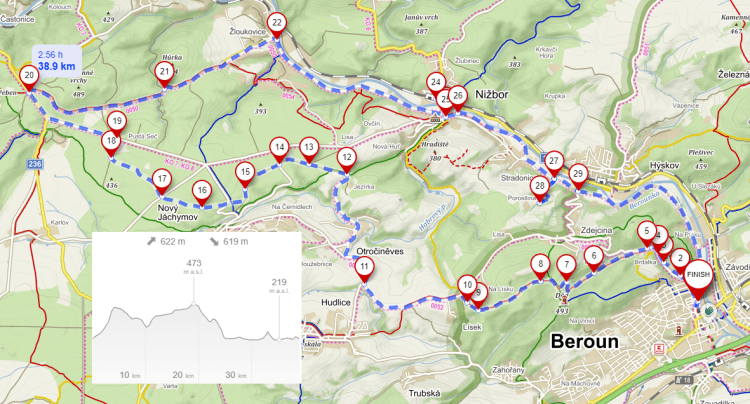
Beroun Nižbor Loop

Parking in Beroun is easy at the starting point and on weekends it is free of charge. You can also start from the point 15 at the restaurant Zastávka in Nižbor, where they know how to pour draft Kofola.

The only tricky part of this ride is a steep uphill section 2 to 3, where you have to be aware of the fact that there may be somebody riding pretty fast downhill. We were lucky not to be hit by these Kamikaze riders. At point 5 you should step inside of the lookout tower Děd and look at the versions of possible reconstruction of this tower. You can also vote for the particular version, but you have to be inhabitant of Beroun.

From 9 to 12 you should pay a good attention where you are riding and select the best possible track on very stony ground. If you want to take a break, point 15 is an ideal spot. After that you will follow Berounka river back to the start. At point 17 you may use the road up to 26, or you can ride with us along the river on the bumpy grassy path. After that you may decide to extend your ride along Berounka all the way to Srbsko, where is another potential refreshment point at The Garden Bistro.

https://mapy.com/s/nomugujeda 34 km, 294 m elevation gain. To see this E-bike trip in context, check our interactive maps. To see more suggestion for your trips you may check Cyklopecky Vychodni Cechy.

Macocha

We returned to this area because our last visit was really a memorable one. This is gorgeous landscape both on the surface and also underground. We had to visit another cave just to refresh our memories. And yes, there we met the creature on the title picture – vrápenec malý (lesser horseshoe bat (Rhinolophus hipposideros)), which is really small about 3 cm long weighing about 5 g.

As the starting point you can use many of parking lots at the entrances of the caves, but if you don’t want to be charged for parking you can start at the parking lot for two cars at the village Ostrov u Macochy. After a ride through the open fields to point 5, do not try to follow red mark downhill to 9, it is not rideable. And you would miss the chance to visit the abandoned quarry at point 8. At point 9 you have to make a major decission – either follow us through the very challenging and at parts not rideable 9 to 11, or use the regular road to Holštejn and return to point 13 to visit the cave lidomorna there and see a bunch of climbers to try their skills.

You should not miss the new church in Šošůvka at 15, which will probably remind you of Le Corbusier’s architecture. At 17 you may decide to visit the cave to see the bat from the title picture. After that you will ride very pleasant downhill Pustý žleb valley all the way to 19. At 21 you will look down to Macocha, 138 m deep gorge. From 23 you can just follow the regular road to the end of the trip, or you can ride the adrenaline path at the edge of a “cliff” 24 to 28. On the left side you will see the old wind mill, which was converted to the weekend house by a family from Brno.

https://mapy.com/s/cosutofanu 25  km, 294 m elevation gain. To see this E-bike trip in context, check our interactive maps. To see more suggestion for your trips you may check Cyklopecky Vychodni Cechy.

Boskovice Loops

We were extremely lucky with our location choice. On May 1, parts of the bike trails were closed for the traditional running event. However, we came later in the afternoon when they were just starting to open them back. So if you plan this ride, remember May 1 is tricky. Another lucky coincidence was Velorex reunion in Boskovice. We have never seen so many of those unique vehicles at one spot. And you may even think that these “cars” were the inspiration for the design of the Aptera vehicle by our friend Steve Fambro.

We planned riding around Boskovice for two days, so we checked for you two different routes. You can, of course, combine them, but it will give you more than 50 km with elevation gain over 1000 m.

As the starting point we have chosen parking lot of the hotel Pod Zámkem, where we were staying, but it seems that you can use that as well for no charge. The north loop will lead you through the mixed forests around the water reservoir Boskovice. At point 2 you should stop and look for a dromedaries. Well, you don’t see too many of those in Czech Republic. And if you have time you can visit “Western Town Boskovice”.

There are no difficult stretches with three short rides on the regular roads. Very enjoyable riding we consider 8 to 10 if there are no pedestrians. After 10 you will have a little uphill fight, so pay attention to stony ground.

The south loop repeats the nice ride on blue tourist mark from 3 to 7 with a lot of “artistic” creations along the path. But then you will have to climb a long hill on the way to 8. After 8 your ride will be a little tricky, for sure you will be glad that you have mountain bike. After you pass 9, it will be smooth sailing back to your starting point. You will be passing through forests as well as through the large meadows and places where the forest fires cleared the space for your viewing enjoyment.

https://mapy.com/s/fojepodoso 32  km, 607 m elevation gain. To see this E-bike trip in context, check our interactive maps. To see more suggestion for your trips you may check Cyklopecky Vychodni Cechy.

https://mapy.com/s/bolehokune 26 km, 498 m elevation gain.

Modřany and Airport Točná

An easy ride through Modřanská rokle, along Vltava and airport Točná. If you do a little side trip at point 20 along the river, you will see the work of the beaver. He decided to cut a really substantial tree – see the title picture – so let us know whether he already finished the job.

The good starting point is a parking at the airport Točná where you can see various small planes parked there or just landing or departing – if you are lucky. If you will be around there on the 9th of May, you may visit the collection of the historical airplanes there. At point 3 you should not miss the biggest frog you would ever see. After point 5 you may experience a little bumpiness, but still an easy ride. At point 11 you may decide that you don’t need any adrenalin and cut your ride short continuing directly to point 18 (at this point do not miss the sight on the right – one of the majestic Prague protected trees). But if you rather follow our map to explore the side arm of Modřanská rokle (actually the prettiest part) from 12 to 17, you should be very careful riding between 14 and 16. After that point there are not too many difficult stretches, just maybe for people which are afraid of heights the climb up to the bridge at point 23, where they may avoid looking down at the path which is floating high in the air.

Reasonable spot for refreshment is the point 22, Drive Garden, where they know how to pour Kofola with nice head. And just in case you will be passing this point on April 30, you may join in so called “Pálení čarodějnic” (Witches burning) celebration.

https://mapy.com/s/rehapazena 18  km, 187 m elevation gain. To see this E-bike trip in context, check our interactive maps. To see more suggestion for your trips you may check Cyklopecky Vychodni Cechy.

Říčany – Southern Loop

The southern loop around Říčany you can start at the railway station, or at the main square in the town, where the parking on Sunday is free. The first part of the ride all the way to point 6 will lead you on very new dedicated bicycle path. Part of this stretch is actually going on the normal road (at point 4), giving you a chance to take a little side trip to the view of the deep quarry at 5.

There is no tricky part of this E-bike trip with the exception of a short stretch after point 7 where you should pay attention especially after the rain, when it could be pretty slippery.  The part from 9 to 11 is called Krásné vyhlídky (beautiful views), so make sure that you enjoy those. At point 12 you may get some refreshment at the kiosk U Františka where they know how to properly serve draft Kofola. And you can also read a lot of signs collected by the owner and donated by the enthusiastic guests. One example below says in translation to English – “50% of teenagers see the life optimistically, the other 50% does not have money for drugs”.

Let us know in your comments whether you found the sign in the title of this blog (saying “We are all crazy here, you will fit in right away!”) – it was not at the point 12.

https://mapy.com/s/batemebako 29 km 344 m elevation gain. To see this E-bike trip in context, check our interactive maps. To see more suggestion for your trips you may check Cyklopecky Vychodni Cechy.

Prokopské and Dalejské údolí

We have described a similar ride earlier, but this time we discovered Dalejské údolí, which we missed earlier. And this was an unforgivable omission. Prokopské údolí is very well known and very intensely frequented by tourist in all seasons. Dalejské údolí is like a forgotten but more interesting sibling.

You can start at the parking lot of Hornbach in Chuchle and ride under Barrandov where you should not miss a visit to abandoned swimming pool nowadays used by sprayers of all ages. Professor Barrande found here (and further in  Prokopské and Dalejské údoli) a treasure trove of fossilized creatures. Therefore this stone formation is now carrying name of the professor Barrande.

Up to the point 4 theride is very easy, but from 4 to 8 you should pay a little more attention as the path can be a little more challenging. From 11 to 12 you will be on a regular road, so the danger will be the regular traffic. After 12 to 13 you will be riding through the modern blocks of flats of the housing estate Lužiny, where the obstacles may be pedestrians and children. From 14 to 15 the path is very steep downhill and if you see pedestrians coming up against you, maybe a prudent solution would be to walk your bike.

An interesting stop may be the memorial to Vlasov army help during the Prague 1945 uprising at point 11 in Řeporyje. As this historical event is still quite controversial, the memorial is super small tank on a tall pedestal / so it may be hard to find. So look around and you may even ask the locals to point you to the right location. The author of the memorial is probably David Černý, who did not either admit or deny his involvement.

https://mapy.com/s/rocotokazu 24.4 km, 280 m elevation gain. To see this E-bike trip in context, check our interactive maps. To see more suggestion for your trips you may check Cyklopecky Vychodni Cechy.

Back in Nové Hrady

We came back to Novohradské hory to check out the new part along the border with Austria, and also to visit the artificial waterfall in Terčino valley and study its construction. As during our last visit we stayed in Zevlův Mlýn, where you can find reasonable accommodation, very good dinner and excellent locally brewed beer. You can start this ride anywhere on our map, besides Zevlův Mlýn a good parking spot is at the main square Náměstí Republiky at point 8. It will cost you 10 Kč/hour, but it is a good point for visiting Restaurace Pod Radnicí, where they will prepare an excellent lunch for you. And if you will not find something not included on the menu, just ask for it anyway – we tested it with Hot Raspberries (Horké maliny), our favorite dessert – and it worked like magic.

After climbing a hill from point 3 you will see how the border with “The West” looked in the last century and you will understand why a lot of people died trying to cross it to the freedom.

At point 11 you may be surprised by the waterfall coming out of the middle of the rocky wall and you will wonder how this natural phenomenon came to existence. After riding to point 12, 13 and 14 you will understand that it was just a little toy created by count Buquoy for the enjoyment of his wife Terezie.

There are several short stretches of tricky riding on this loop, but you have to pay attention especially between points 16 and 17 where you may encounter pedestrians on a very narrow path – you may even consider walking your bike.

https://mapy.com/s/lupevojopu 31 km, 400 m elevation gain. To see this E-bike trip in context, check our interactive maps. To see more suggestion for your trips you may check Cyklopecky Vychodni Cechy.

Suchdol nad Lužnicí Loop

A pleasant ride with a negligible elevation gain. We described this loop earlier with addition of the visit of České Velenice, so you might see our comments there. The difference this time was the fact that connection 5 to 7 was closed for some reason, so we had to ride through Trpnouze and Hranice – interesting arrangements of villages with different names on each side of the road.

You should definitely use the red mark path along points 9 and 10 and not go by the highway on the right. The highway is completely in Austria, but it is hard to say… Besides, close to the point 9 is an interesting memorial and also a geocache GC7WQRJ. You may learn about the situation on the border with Austria in the fifties and sixties in the description of this cache.

https://mapy.com/s/cahugubogu 40 km, 70 m elevation gain. To see this E-bike trip in context, check our interactive maps. To see more suggestion for your trips you may check Cyklopecky Vychodni Cechy.

Cherry Orchard in Bloom

A slightly modified ride from couple years ago which can be recommended for this time of the year when passing through the cherry orchard after point 17 is a highlight of the trip. If you are inclined to a little excitement, follow our map from 11 to 16. Otherwise you can avoid this sloping narrow path by following the bike path A25 and join the map on climb to Třešňovka at point 17. If you ride with us, make sure that you walk your bike at point 16, it is very dangerous dip.

We described this ride earlier, so now we only mention refreshment point at 11, where they really know how to draw a good glass of Kofola, or at point 35, where you can have a coffee or relax and read a book at the great community center and library. At point 6 you can visit a David Černý’s statue of Lilith, which we described just when it was being installed.

https://mapy.com/s/lutemameme 30 km, 200 m elevation gain. To see this E-bike trip in context, check our interactive maps. To see more suggestion for your trips you may check Cyklopecky Vychodni Cechy.

Dobřejovice

Easy ride with several very short adrenaline pieces. A convenient starting point is the parking lot at Hostivař dam, not very crowded out of the season. Parking there during a hot summer day would be tricky. The first part up to Dobrá voda is easy, but after that you have to decide whether to follow our map, or the bike path A23 to point 8 to rejoin the map. From 3 to 8 you have to pay a good attention since the path is pretty narrow. Around the town of Průhonice, you will be passing a lot of fancy houses, one of the greatest estate is at the point 11. If you want to visit Andrej Babiš, you may swing by the point 19 in Průhonice. At point 13 you may try a little pumptrack to brush up on your skills to ride various bumps and turns. From 9 to 20 you will be riding around Průhonice Park, which you should definitely visit, if you never been in there. Unfortunately they do not allow biking through there.

If you reach point 17 around lunch time, make sure that you stop by at the restaurant 11ka bistro which is of a very high level and at the same time very affordable. It got very high reputation in very posh location Špindlerův Mlýn and now surprises the guests here. It is advisable to make a reservation! However, Monday and Tuesday it is closed.

https://mapy.com/s/mevenugaje 29 km, 192 m elevation gain. To see this E-bike trip in context, check our interactive maps. To see more suggestion for your trips you may check Cyklopecky Vychodni Cechy.


Říčany

Nice and easy spring ride. Starting at the parking at the train station Říčany. You will quickly arrive at the pond Jureček and restaurant U Jurečka – it is the place where something is happening all the time. The last time we visited we saw a huge selection of fish for sale – it was the first time we saw the locally caught catfish (sumec). You can also park at this place to start your ride.

If you would feel tired at point 6, you can cut the trip short going straight downhill to point 8, but you would miss the ride through Voděradské bučiny (beech tree forest). In the alternative maps below, we send you through this shortcut intentionally… It is pretty steep and slightly technical part of the trip, but in the point 10 (alternative map) you will meet the statue of the salamander or newt. The size is closer to the newt from the famous book by Karel Čapek – War with the newts.

The alternative map will also lead you to the Kiosek U Františka at point 7 (also called Františkovy Lázně), where you can study many interesting signs and have a perfect glass of Kofola.

https://mapy.com/s/danolotofa 34 km, 350 m elevation gain.

A shorter alternative map…

https://mapy.com/s/nucozofape 24 km, 177 m elevation gain


Back in Brdy

Maybe it was too early to check our favorite location for easy riding – Brdy. It was sunny, but pretty cold. And on top of it, we tried a little piece which we did not check earlier, and it was still very muddy. But if you would like to follow our trip, it may be already fine – we were here at the end of February. Luckily, during our trip, the restaurant Čunčí huba (U Dernerů) was opened…

The most of this ride does not need any special comments, but 3 to 10 definitely requires a mountain bike. Especially 6 to 10. If the following the red mark from point 6 looks too sketchy, you can follow the path peeling to the left and when you reach the forest road with green tourist mark, follow the road to the right (uphill). If you are too cold or tired at the point 10, you can take a shortcut to point 12 – you will not spare yourself any elevation gain, but you will get warmer biking uphill.

Good starting point for this trip is the parking lot at the top, or you can take train to Řevnice and bike uphill from there.

https://mapy.com/s/jocateruze , 31 km, 360 m elevation gain. If you want to check our earlier rides in Brdy, just type “Brdy” into the search field…


Short Prague loop

This is a very short ride which you can combine with many potential rides through this beautiful city. Maybe you can combine it with some of our earlier maps... We just wanted to point to some interesting features which you can find in this map.

At the start point you will be entering the “scary” tunnel (yes, it was scary when we were walking there with my grandpa in the 1950`s). Check your reflection on the wall at the entrance – here you can get a perfect distortion of your image for free, unlike at the “Bludiště” at Petřín hill (which was made famous by Dan Brown new book The Secret of Secrets). You will probably not need the refreshment at point 2 at this point, but make sure that you save this location for your next time at that neighborhood – this is very likely the most unusual coffee shop combined with a library and cultural center, definitely worth the visit.

It is much better to ride in the direction of the Vltava flow since the bikers going in the opposite direction should share the road with the cars. (Not everybody follows this rule, but at least you can give those unruly bikers your middle finger.) You will not miss the kayakers training at the artificial white waters on your left side and you may think that this is the place where Czech gold medalists are practicing their craft. Between point 3 and 4 you may look for the penguin from the title picture – let us know whether you found him. At point 4 you can stop and rent for free a ball, a frisbee, badminton rackets, petanque balls, etc. – “Park U Vody” is one of the newest and nicest neighborhood parks in Prague.

At point 7 you cannot miss the slightly oversized chair and lamp in a tiny Tamirův park. In point 8 you can turn left and go back to the brewery Marina, again recommended by us for your visit in another time. From there you can see a large boat at the end of the Holešovice marina which looks like a abandoned pirate ship – and it probably is just that.

From 11 to 12 you will be going through construction zone, so you may bypass it on the right. At point 13 you should pay attention not to slide down to Vltava (you may walk the bike). At point 14 you should stop and look at the new wall art. How it looks when you visit may be way different than the pictures we took…

https://mapy.com/s/momalugajo 15 km, negligible elevation gain. To see this E-bike trip in context, check our interactive maps.

Poděbrady Nymburk Libice – Easy short ride

This is the ideal ride for starting your season when you just want to check whether your bike will still work. We did this one a long time ago (about 10 years ago) and now we realized that the bike path had a lot of improvements – new surface in many places and new bridges which make biking a lot better.

As the parking in Podebrady is quite tricky, we recommend starting at the space before the bridge (where it is free of charge). If you will follow us here, let us know whether the restaurant at point 6 is open. When we visited it, it was closed, even though the map was showing it as open. And, of course, do not forget to visit Libice nad Cidlinou, where you can find the memorial to the year 995 massacre of the Slavnikovec dynasty by Premyslids. It would make you think how everything could have been different if this “little skirmish” ended up with different ending.

28.9 km, negligible elevation gain. To see this E-bike trip in context, check our interactive maps.


Just Checking…

We had to go to check how many more trees the beaver cut down in one of our favorite destinations – Meanders of Rokytka in Prague. And, yes, we caught him working on another one – the first picture does not show it that clearly, but the second one is the presentable proof. The map we used was the old one, so check our earlier rides. The most significant new feature you can find at the entrance of the tunnel – reflective wall which displays anything and everything pretty distorted…

Železná in Český Les – Northern Loop

After riding along the border with Germany to point 3, we tried to find the geocache at the very border. This part was not bike accessible so we had to push hard to the abandoned border crossing where the cache should be hidden. But no luck this time… After point 6 you will have to use the regular road for a little bit… We were trying to find some alternative, but nothing looked rideable.

Rozvadov is a typical border town with gnome sales and casino – convenient amenities for German tourists. At point 8 you may explore the abandoned fortification from the WWII.

Be ready for a long uphill ride 11 to 13 and for very rewarding downhill 13 to 14. At point 16 you will be close to a castle Diana, which was returned to the family Kolowrat in 1992. Kolowrat family is a very prominent family of Czech nobles – actually, if you will come along some castle in Czechia, you may guess that it is or was owned by some member of this family.

Close to the little pond at point 16 you will see a wooden sculpture of the waterman (vodnik). It looks like it is a work of the local carver who has many carvings placed in this area.

https://mapy.com/s/mutapaduka 36.7 km, 381 m elevation gain. To see this E-bike trip in context, check our interactive maps.

Železná in Český Les – Climb to Pleš

Again, our favorite “Český Les”. The village Železná, which sits on the Czechia – Germany border is a convenient starting point for several E-bike trips. Accommodation in the resort Český Les can be strongly recommended. And as any place close to the German border it is flooded by plastic junk of garden gnomes (see the picture), very popular in Germany. Surprisingly they had even stone and steel creations – actually not bad at all.

This time we went to the loop south of there with the stop for lunch at Bělá nad Radbuzou. The not very attractively looking restaurant Radbuza actually provided very tasty meals and drinks. So, do not be distracted by looks of the entrance, check the inside. The only alternative for refreshment is restaurant Pleš on top of Pleš (17), where you may need a little break after long ride uphill from 16.

There are no problematic parts of this ride, so any bike would be fine on this one. At point 9 you should stop at the memorial and read about the last American soldiers fallen during the last days of the WWII and about the operation “Cowboy” saving a herd of Lipizzaner horses from being eaten by approaching hungry Russian soldiers.

It may look tempting to cut from 11 to 13 by following the yellow sign, but for some reason you would have to cross the electric fence and go through the free range animal pasture. So we rather followed the regular road to point 13.

https://mapy.com/s/mepurufana 43.1 km, 747 m elevation gain. To see this E-bike trip in context, check our interactive maps.

Great Falls, Montana

Well, it is quite unlikely that our followers would happen to be in Great Falls in Montana, but you never know… Along your path you would see a lot of metal sculptures, some of them even pretty unusual. The only tricky part is the stretch 6 to 7 and back, so be careful there.

But just in case you would visit Great Falls, do not miss have a drink in a Tiki bar where you can see mermaids in action through the window behind the bar.

https://mapy.com/s/gokalerolo 55 km, 296 m elevation gain.

Vranov and a Dip to Austria

Vranov dam was finished in 1933, so it is one of the oldest dams in Czechia. Castle Vranov nad Dyjí has a long history going back all the way to the year 1100. This time of the year was not crowded with tourist, but in the summer this area may be busting at the seams – Vranov dam is a popular destination for all kinds of water sports.

We stayed in the pension Jelen (Deer), which we can recommend without hesitation for its very friendly owners and great breakfast. We show as the starting point a tiny parking next to the popular watering hole Country Saloon with very authentic wild west vibes.

At point 4 you will cross to Austria and soon you will join regular road which will lead you to the smallest town in Austria Hardegg with its imposing castle. After crossing Thaya (Dyje) over the bridge which for closed for decades, you should not miss a little side trip to point 10 from which you can see this little town perfectly.

You will end your trip riding along Vranov lake (visit the bridge at point 14) and visiting a little bridge of countess Mniszkova at 15.

https://mapy.com/s/dubacecume 36.4 km, 643 m elevation gain. To see this E-bike trip in context, check our interactive maps.

Zruč nad Sázavou

If you will ride here at this time of the year, you may find yourself in the middle of endless bright yellow fields of blooming “řepka” (rapeseed) fields.

By the way, řepka does not have a good reputation in Czechia, thanks to the famous politician Andrej Babiš – you can read about the case in many articles.

Anyway, you can start your ride in the square in Zruč with nice view of the castle. Most of the ride is very pleasant, you have to pay attention only to the downhill ride 3 to 4. We made a mistake following the red tourist mark from 6 to 8, which you really cannot ride as the path is too narrow and low – yes, low, you have to climb under overhanging branches. So we recommend going as marked on the map, but we did not actually ride this piece.

At point 9 you may park your bikes and visit the ruin of the castle Chřenovice and talk to its owner who is working on the renovation every day and expects to finish the job in four years. We seriously doubted that.

You will be passing twice through the point 2 where you can refresh yourself in a easy going pub “Ve staré škole”. At the end you will use the new bikepath around Zruč and ride through the castle park.

https://mapy.com/s/nujamakusa 38 km, 600 m elevation gain. To see this E-bike trip in context, check our interactive maps.

Crossing the Stream – Kaznějov

This ride was definitely not for the weak! Climbing over and under fallen trees and crossing the stream about million times… Definitely mountain bike and a little experience in riding through the rough terrain would help.
Parking in Kaznějov was easy and restaurant Modrý Hrozen was good choice for our lunch. Yellow tourist mark leads you through the nice forest and fields, but at several places the road was obviously used by heavy machinery before. At point 4 you should not follow the yellow markings, but take a turn left to point 5 and rejoin yellow mark at point 7. The connection 4 to 5 is not mapped (we reported it and it may be fixed by now – yes, it is fixed, it just show how responsive is the team of mapy.com). The stretch 15 to 16 may be bikeable only by Red Bull professionals, but even they would have to climb over and under several logs.

After that will come the big decision – to go along Kralovický potok (18 to 28) or follow the green mark from 18 to 29. The valley of Kralovický potok is beautiful, but it requires you to cross the water eight times. So you would ride back to Kaznějov with water in your shoes. This was our choice, but it was definitely worth it. At point 24, which is a little off your path you may visit the absolutely perfect secret camp site – you may be wondering how could some people drive there with their cars.

The rest of the ride is quite pleasant, even though you would cross the water several more times (Nebřezinský potok)

– but your shoes are already wet, so why not.

https://mapy.com/s/dobebokamo 32 km, 570 m elevation gain. To see this E-bike trip in context, check our interactive maps.

Bítov Castle Loop

This area is probably pretty busy during the high season. Castle Bítov’s history goes back to the 11th century as one of the oldest castles in Moravia. The last owner George Haas, who had large collection of live animals in the castle was facing prospect of being expelled from Czechoslovakia after the second world war and rather than abandoning his beloved animals committed suicide…

Anyway, we were here before the season started, we could not visit the castle. Maybe next time…

Parking is conveniently available at the square in Bítov, wher you can also find an excellent restaurant “U Tesařů”. This ride is quite easy, any type of bike would be fine. The only part which you have to walk your bike is from 10 to 11, where you will be crossing quite narrow bridge. If you are following us, you know that we try to avoid regular roads, but in this case we could not avoid that. So from 13 to 16, you will be on asphalt with cars passing you quite fast – especially from 13 to 15. You may probably cut a piece of this stretch by going from 12 to 14 on the muddy path, but we did not confirm that choice. So, if you do that, let us know how did it go.

Make sure that you don’t miss the eagle statues in front of the tower Rumburak (just past the point 3), and a little ruin of Rotunda Heinrichsruhe at point 18. When you arrive back at the square where you started, you can continue on the road to point 20 to enjoy the view of Castle Bítov across the river, and to 21 to visit the ruins of Cornštejn Castle.

https://mapy.com/s/fufozotusa 30 km, 620 m elevation gain. To see this E-bike trip in context, check our interactive maps.

Rokytka Again

As the starting point to this ride on the map we have chosen Dookie Bike and Snow Shop, the friendliest bike shop and service place in the world. You can, of course, start anywhere on this loop, the part of which we have ridden many times. Anyway, we have discovered a little gem this time. This short stretch 14 to 19 seems to be from another country… It is called Čihadla and it is a marsh area created again by Rokytka – our favorite stream in Prague.

The only other comments may be the point 9 with boulders in the path, point 13 where you have to go down and up the stairs, and point 33 “U Eriky”, where you can have a little break for beer or Kofola.

https://en.mapy.cz/s/pujebureho 29.4 km, 335 m elevation gain. To see this E-bike trip in context, check our interactive maps.


Mirotice – If you like a Torture

We started from Mirotice, a place where Mikoláš Aleš was born. The blue tourist mark path is named for this famous Czech artist – you can find his creations on many houses in Prague. And it was quite an art to follow this blue path. From 3 to 4 you are passing under the highway through the construction site – on Sunday it was abandoned, but during the week it could be challenging. It would be probably better to stay on the road from 2 to 8. But then you would miss the first torture – 5 to 6, where first it would be hard to find the path under long dry grass (see the pictures) and later uphill climb with a lot of sharp stones. From 6 to 10 you may recover from the first torture session before the 10 to 11 piece. This stretch looks like freshly plowed field, but you will be only admiring the work of wild pigs. There is no way to bike through that – you just push your bike and hope that the pigs got tired and stopped their hard work. From 11 to 12 you will be biking most of the time only with several trees slowing you down.

And if you want to avoid all the swearing and sweating, you can go from 2 to 12 on the asphalt road, which, as you know from our blog, we are trying to avoid as much as we can. But then you would miss the sight of the castle Karlov, which can be better viewed from the east through the majestic tree alley. That alley may lead you to the road to Ostrovec avoiding thus the pigs work 10-11. You can also pick here the geocache GC1M9RQ .

From the point 12 you will have no problems riding and you will be rewarded by the nicest part of this E-bike trip 13 to 14. You can visit very unusual spa Vráž, where you would go just for being far from anywhere and enjoy the quiet walks around in the forest, but we did not test this option.

https://en.mapy.cz/s/fepatenaba 30 km, 350 m elevation gain. To see this E-bike trip in context, check our interactive maps.

Checking with the Beaver on Rokytka

Last time we rode very similar loop in Prague, we noticed the beaver’s work in the meanders of Rokytka stream. So, we had to check on his progress… Well, there was this report in National Geographic of the beaver in Brdy who built the dam much faster and with much less paperwork and expense than the Czech building company. However, we have to report that the Rokytka beaver realized that there is not enough material to build the dam and gave up on his project.

We modified the original ride by going through alternative paths along the main bike path and explored around. There is a number of alternative parking lots where you can start your ride, for example close to the point 6, next to the pump track where you can test your riding skills. At point 3 you will be riding on Sir Winton’s Boulevard, the new connection between Holešovice and Bubeneč, which was opened very recently.

At point 20 you will enter “the tree tunnel” which may be quite busy in the summer as it provides several accesses to the swimming. Close to point 22 you may check for the geocache – this particular one is one of the clever ones.

https://en.mapy.cz/s/becuhujoto 37 km, 320 m elevation gain. To see this E-bike trip in context, check our interactive maps.

Loop with Kokořín view – Winter Walk

A short walk which we would never try with bikes – stairs and ladders would make it rather difficult. But for the winter month it was a nice break with no tourists in sight.

There is a couple of options to park your car, the best starting point is at the Restaurant Pobuda, but the space there is quite limited. After point 2 you will quickly realize that this is not biking trail. At several points the path is quite narrow (see pictures) and at points 6 and 7 you will climb the stairs. Do not miss the view of Kokořín at point 3. This trip does not need any comments, just enjoy the pictures.

https://en.mapy.cz/s/puvopejabo

Walk around Kellner’s estate

Mister Kellner was the richest person of Czechia and one of the richest people in the world. His company, PPF Group, is globally known and respected. Not surprisingly, Kellner’s “garden” in Podkozí has a fence 5 km long. It is actually game reserve for fallow deer. We decided to walk around this forest and find out whether following the fence is doable on our bikes. Well, it is, but it is not recommended, you would have to carry your bike over fallen trees several times up to point 2.  And obviously, the narrow path is used by horse riders.

At point 3 you can see the entrance to the old mine and later on the downhill part you will see several dilapidated houses, probably not owned by Kellner’s family.

To begin your walk you can park at the Start, or a little higher on the point where the walk departs from the road. If you would like to have a lunch during your visit, we can recommend the Srub Podkozí restaurant.

https://en.mapy.cz/s/hofodamove 6.2 km.

Ride in a Warmer Climate – Tenerife

When it gets this cold in Prague, it is not a bad idea to get some sun somewhere else. And a return flight with SmartWings is not even that expensive. And there is a company renting E-bikes plus a guide to show you around. Yes, we did this little ride with our excellent guide Maciej and his selection of E-bikes. The ride was fun, but we have to make a little comment: The website of this company may be a little confusing – our trip was called Lunar Landscape, but actually it did not go to the Lunar Landscape and it did not start from “famous biker’s cafe” in Vilaflor (there is not a famous biker’s cafe).

However, if you don’t want to use them and you rent your bike somewhere else, you can follow our map and combine your trip with a walk to very interesting area of Lunar Landscape. Unfortunately, biking to that super interesting place is forbidden (and as Maciej told us “demanding and very technical”), and so you have to leave your bike at the point 4 and continue on foot following red and yellow mark uphill. Obviously, if you are on a guided trip this is not an option.

If you start your trip on the parking lot in Vilaflor, you will first ride 2.3 km on an asphalt road up to point 2, where you will join a wide dirt road. This will lead you all the way to point 3, an obvious end of the road at the steep canyon which may sometime contain a little stream. That is why it is called Barranco del Rio. Most of the ride will be winding its way through the ancient Canary Pine forests with the views down to the sea beaches and up to the Teide volcano area.

On the way back you will climb to 1945 m and after that enjoy a long ride down to the starting place. The last 4.2 km from point 5 you will be on a steep downhill asphalt road going as fast as you find enjoyable.

https://en.mapy.cz/s/lovetemuna 35 km, 780 m elevation gain. To see this E-bike trip in context, check our interactive maps.

Climbing on Děd

A little walk to see the top of Děd above the town of Beroun. We knew that there is a view tower, but the style of this thing was surprising. This view tower is actually the first one ever built by the Klub českých turistů in the year 1893. Unfortunately, now you cannot climb to the very top due to the shaky state of this tower.

We biked part of this trip before, so the steep slope above point 4 was not surprising. Parking on the street at marked point was easy.

https://en.mapy.cz/s/lujagadepa 6.4 km, 250 m elevation gain. To see this walk in context, check our interactive maps.

Běchovice Praha – Winter Walk

We were not sure whether this would be bikeable, and it was really cold. So, just another entry to Winter Walks… We took the train to Běchovice and return by train from Kyje. The train goes every 30 minutes, so you don’t have to worry too much about timing.

The walk starts on the north side of the platform and the part to point 2 would probably be the only questionable stretch for biking. You will walk by two interesting ponds, the second one, V pískovně, looks like some marsh in Louisiana.

At point 13 you cannot miss the viewing tower Doubravka created from locally sourced wood sticks. This is probably the most interesting point of this walk.

https://en.mapy.cz/s/lupohajena 6.1 km. To see this walk in context, check our interactive maps.

Checking Vítkov after New Year Fireworks

Version of this blog we posted exactly one year ago… And this year it was exactly the same, nice weather and big mess under the statue. This time we were looking for another geocache and on the way there we discovered “a carousel”, a circular ride connecting the bridge to the ground (7). And it is a fun to ride it – try to go fast – but make sure that there is nobody walking in front of you. (And to find the geocache you don’t have to go down, by the way.)

Last night it seemed that most of the fireworks were coming from the top of Vítkov next to the statue of Jan Žižka. So we biked there just to check… And it had to be wild. We can understand that some people do not want to carry back the spent fireworks packages, but why it seems to be a good idea for some to just break the empty bottles?

On the way you can check the entrance to the tunnel to Karlín which was beautifully renovated and the new entrance can serve as a nice meeting place. Quick pick up of another tiny geocache was a little bonus for us.

https://en.mapy.cz/s/posagubuha 13.8 km, 250m elevation gain. To see this E-bike trip in context, check our interactive maps.


Two Bikeable Tunnels of Prague

We have mentioned parts of this ride before, but, interestingly, you can always discover new aspects of this short and pleasant ride, especially if you ride it in two different directions. In the first case you start with a tunnel built for the railway in 1870 (between 3 and 4) and later, after a lot of discussions, changed into a bike route in 2010. And you will end going uphill through tunnel connecting Karlín with Žižkov, which was built in 1953 partly as a bomb shelter. Nowadays it is used as a laboratory  – a branch of the Institute of Nuclear Physics of the Academy of Sciences of the Czech Republic in Řež near Prague. A particle accelerator is installed here, a smaller version of an accelerator similar to the one in CERN in Switzerland. It is hidden behind a steel door on the side of the tunnel.

At point 6 you will join the dirt road uphill which will lead you to the top of the hill Třešňovka (7) with signs showing directions to many Czech mountains which you can imagine seeing from there. Another interesting part is the ride along meanders of Rokytka (8 and 9), where you can spot a beaver’s work on one of the trees close to the water.

This ride is quite short, so you can just turn around and ride it in the other direction and you will see that you will notice a lot of different details.

https://en.mapy.cz/s/nabojacagu 18 km, 240 m elevation gain. To see this E-bike trip in context, check our interactive maps.

Chuchle Loop

Maybe this was the last warm day of this fall. We saw the red leaves climbing the rocks of Barrandov and decided to explore this area closer. You can find convenient parking in front of the Hornbach store.

The autumn colors during the whole ride were incredible. Barrandovské skály (Barrandov rocks) are world famous for showing a plethora of geological features and also for being a source of petrified fauna and flora (trilobites).

The Barrandov quarter is actually a very young part of Prague. It was built in 1920’s from scratch by Václav Havel, the father of our famous Czech president Václav Havel.  Not many people in the world can say that they were presidents of two different countries, except President Havel. Barrandov is not only a luxury living quarter, but it is also the center of the Czechoslovak film industry.

The ride was smooth without the need of any special comments. However, points 2 and 4 are worth the little side trips. Point 2 is a wall painting gallery in the place of a dilapidated swimming pool, and point 4 is a natural lake in the former quarry in Prokopské údolí. Point 6 is the location of brewery Prokopák  which has a very good restaurant. After point 12 you may come across freely roaming goats. Who knows…

https://en.mapy.cz/s/kugumetena 25 km, 280 m elevation gain. To see this E-bike trip in context, check our interactive maps. For other non-English version of this page click the green box at the bottom.


Mníšek Líšnice Loop

If you follow our trips, you already know that our starting point in Mníšek pod Brdy is close to the entrance to the castle. This time, however, most of our E-bike trip was on the other side of the highway. And, even though it was Saturday, we did not meet too many people there, unlike after we crossed back to Brdy through Řitka. (Some nasty Czechs interpret the village name as “little ass”.) It was really fall…

Most of the ride was quite easy not requiring any special skills. However, we added a couple of challenges. At point 5 you can ride through the little stream or use the narrow bridge. At point 6 you have to pass under the highway through very sparsely lit (actually not at all lit) underpass… But riding uphill from point 7 to 8 is a fight which definitely requires a mountain bike. Another hairy part is downhill shortcut stretch from 10 to 12 (not mapped – you just turn left after crossing the road). We do not recommend this part if you don’t want to end up in your car with a lot of mud on your bikes and shoes. Ride through point 11 is much more convenient.

https://en.mapy.cz/s/delucacoca 32 km, 515 m elevation gain. To see this E-bike trip in context, check our interactive maps. For other non-English version of this page click the green box at the bottom.

Český Les

One of our followers pointed out that we were ignoring one of the areas of Czech Republic which he considers as a “must go” which was Český Les (Czech forest). We really hadn’t visited this area on the western border with Germany before. And, yes, we were surprised. It is as pretty as Šumava National Park, but with far less tourists and bikers.

We started our ride from Lesná, a small village west of Tachov. Even though part of our ride was on a regular road, we did not see more than two cars. On the forest roads from 2 to 11 we did not meet anybody! Most of the ride was in the area which was not accessible to Czech citizens during the communist regime – the government was paranoid about the people escaping to “the west”. One of the reminders of these times are the dilapidated barracks of the border protection unit Rota Vašíček at point 4. It definitely feels a bit eerie on a cold cloudy day.

If you decide to make a little side trip (very steep) from 6 to 7 you can climb to the watch tower (known as Havran) which was used to monitor the German side of the border. Half way up to the top of this construction is an exhibit showing various ways people were trying to cross the border to freedom – everything from home made tanks to balloons made from raincoats. A part of the barbed wire “border before the border” construction is also preserved there.

At point 10 try not to miss the lizard carved out from the boulder next to the road on the left. It is a pretty impressive piece of work.

https://en.mapy.cz/s/jalukecoza 32 km, 526 m elevation gain. To see this E-bike trip in context, check our interactive maps. For other non-English version of this page click the green box at the bottom.

Litoměřice Roudnice Loop

This was a very relaxing ride along the Labe river. At this time of year in Autumn you will see why this part of the Czechia is called the most fertile “polabská nížina“, or sometimes “zahrada Čech” (garden of Czechia). We have a true appreciation for all the agricultural products being grown here.

You can start this trip either in Litoměřice (like our earlier ride) or in Roudnice. The first part from Litoměřice will lead you through the town of Terezín with the very sad history of a Nazi concentration camp. And a significant part of the ride will go on the regular road. The other side of the river from Roudnice to Litoměřice goes over a newly built comfortable bike road.

https://en.mapy.cz/s/lurovebaho  42 km, negligible elevation gain. To see this E-bike trip in context, check our interactive maps.

Úvaly to Masaryčka

You can catch a train from the Masarykovo railway station to Úvaly every 30 minutes. And from there you can enjoy a nice and easy ride back to the Masaryčka station. In the Klánovice forest you may find a lot of delicious mushrooms! The only difficult part of this trip is between 9 to 10 which you should not even attempt to ride! Just walk down these stairs.

https://en.mapy.cz/s/jerefutofo 27 km, 212 m elevation gain. To see this E-bike trip in context, check our interactive maps.

Kladruby in Autumn

This is an ideal ride in autumn. And this year was unbelievable for the mushroom hunters. Mushrooms were everywhere, and some sizes were impressive.

We reported on this area earlier in the spring, when the horses were out in the pastures. This is a protected UNESCO site known for its tradition in horse breeding culture, so you should definitely read about that and maybe go on one of their tours. The only part about this ride deserving comments is in the stretch between 7 to 13, where it is sometimes hard to see the bumpy ground covered by tall grass. At point 11 you must walk your bike around the fallen tree.

From 15 to 18 you will follow the “sandy beach” where a lot of people were camping even in this relatively cold weather with the main goal to catch some fish.

An interesting point can be found at 5 – where there is the sand dune Semínský přesyp, which you may easily miss, because it does not look like sand dune. However it is the unique place where you can find “kozinec písečný” the flower which was considered non existent in Czechia. The protected area is rather small – and there is no way to find its borders.

https://en.mapy.cz/s/fojupudore 30 km, negligible elevation gain. To see this E-bike trip in context, check our interactive maps.

Optimizing Loops Around Modrava

Šumava is our favorite place to go for E-bike rides. So we went there again to show it to our daughter and her fiancé. Obviously we would not fit in our car with the bikes, so we had to rent locally. We tried new Apache and Crussis E-bikes. And, actually we did not see any big difference from our good old Apaches… We described trips from Modrava earlier, going to the west or east, so this time we just made it a little longer and added some points to the rides.

So going to east starts with a long uphill ride to point 4. After that we added a stop with a visit to the exhibition of the history of the border at point 7. Back in the old times we could not even get close to the border to see how it looks from our side, but I was lucky to see it from the German side during a short visit to “the west” in 1969.

After that you can enjoy a long smooth ride downhill and through the meadows to Knizeci Plane at 8. Couple hundred meters after that you may notice works of beavers on the right hand side of the road. After that you will be passing Borova Lada and Nove Hute and climbing to Churanov. It is possible to use a shortcut 11 to 14, but following our map is using easier path and allowing you to stop at an excellent refreshment point (cukrarna Ella) at 12, where you can even charge your bike.

https://en.mapy.cz/s/ravamokeku 49 km, 848 m elevation gain. To see this E-bike trip in context, check our interactive maps.

Going west start with a short downhill on a road to point 2. After that you will follow an Vchynicko-Tetovsky canal which was used for transporting wood out of the forest. It is 13.6 km long and definitely a technical curiosity worth noting.

At point 7 starts a long uphill struggle – you will be really happy to have an E-bike. We recommend to take aside trip to point 9 to visit Prasilske lake – however, you will have to walk the last couple hundred meters, not even E-bike would help here. Another side trip is to the top of Polednik with the observing tower allowing you to look at the devastation of the local forest by combination of pollution, bark beetles and tornado.

After Polednik you may ride only downhill if you will not visit Trijezerni slat at point 12. At the end you will definitely deserve a beer in the brewery Lyer at point 13, where you can also stay for the night.

https://en.mapy.cz/s/mogumakavo 42 km, 764 m elevation gain. To see this E-bike trip in context, check our interactive maps.

Strašice to Láz and back (2x across Brdy)

This time we started in the parking lot in Strašice because we were picking another E-bike for our friend visiting from the America. And it is not a bad idea to start from there since our usual parking at the entrance to CHKO can be pretty crowded. Besides, if you need to rent the bike, the rental place is just across the street from there. Cyklo Brdy will rent you a bike of your dreams right there. And if you mention this blog, you can expect a discounted rental rate.

The trip will take you to the top of Brdy, next to the “dopadová plocha” (landing area) Tok (2), the place which served as target for the army exercises back in the previous regime – and from where not all unexploded ammunition was eliminated. (If you stay on the bike path, you will be totally safe.)

Then you will enjoy a long ride downhill to Láz with the possible quick stop at point 3 to get the peek at the lake supplying the area with drinking water – so no swimming, please. In Láz you may consider stopping for a beer or Kofola, but if you continue to point 5 in Nepomuk,  you can meet a lot of biking enthusiasts in the Cykloklub Brdy Nepál where you can enjoy excellent dršťková (tripe soup) and beer.

The next points of interest are “red quarry” at point 7 and ancient oak at point 8. There you can also look for the geocache masking itself as a birdhouse.

https://en.mapy.cz/s/kodufacase 48 km, 675 m elevation gain. To see this E-bike trip in context, check our interactive maps.


Český Šternberk/Sázava

Parking in Český Šternberk can be tricky especially on weekends since this castle is quite popular destination. The best guess in the morning is the parking close to the river. This parking is also used by the people renting the canoe here for the trip down Sázava.

After following the river for about 4 km you will go uphill for about 2 km. At the village Bělokozly you may follow the road or go through point 2 to enjoy a little off-roading before joining the road again and going downhill to a town of Sázava with its famous glassworks Kavalier and medieval monastery, founded in the year 1032.

If you arrive there around lunchtime, you may stop at Kozlovna at point 3. After crossing the river you will be for a little bit on a busy road up to point 6. It is easy to miss and it does not look like a rideable path, but it actually is OK. In point 10 you may decide to visit the ruin of the castle Talmberk. On the way up you should be aware of the number of beehives just next to this steep uphill path (but it is OK to you miss this ruin).

From 10 to 12 you may have a hard time to find (and bike) the narrow uphill path. Also the downhill way 13 to Ledečko is quite tricky. The alternative is to go to Ledečko via regular road, but if you follow our blog, you know that we avoid regular road as much as we can. In this little village you can have Kofola at the restaurant just next to the bridge. This spot is very popular with “water people”, so it can be very busy.

The most beautiful part of this E-bike trip is from 20 to 21. You will probably not meet anybody there and you will be riding on the edge of the slope with nice views. And at the end of the ride you will probably not miss the ice-cream shop just next to the parking lot.

https://en.mapy.cz/s/kucevohufu 32 km, 525 m elevation gain. To see this E-bike trip in context, check our interactive maps.

Brdy from Řevnice

This E-bike trip is a compilation of several visits of the North side of Brdy. Starting from Řevnice is quite convenient – you can get there by car or train (restaurant at the train station is actually a new brewery – highly recommended). We tried to find the path up to the top of the range at point 2 and 3, but what is marked on the map actually does not exist in reality. So, you will follow the river to Dobřichovice and your adventure will start at point 5. Ride from 5 to 6 is on barely visible path uphill and from 6 to 7 on a visible path, but even steeper uphill.

At point 11 you will join Fabián’s educational path – Fabián is a good ghost of Brdy – and follow this nicely maintained path all the way to point 16. Last part on yellow tourist mark is a fight, but reward of visiting Jezírko (Little Lake) at point 17 is worth it. We wrote about this place in a previous blog – you will be actually in El Paso, Mexico.

From point 19 to 21 you can follow the hordes of bikers on the red tourist mark, or you can go with us straight through the forest. Do not go too fast – at point 20 you will have to walk your bike down and up across a little stream. From 22 you can go directly to 24, but in that case you would miss the viewpoint at 23.

From 25 you can go straight to 27, but you would miss very narrow and tricky riding 26 to 27. From 27 to 28 you may rather walk than ride. However, stretch from 28 to 29 is one of the nicest places with views in Brdy. Obviously somebody built some log house there under the cliff, and weather destroyed it…

Another tricky riding awaits you between 32 and 33. But after that it is easy all the way to the finish.

https://en.mapy.cz/s/jarujavudu 30 km with 667 m elevation gain. To see this E-bike trip in context, check our interactive maps.

Pohorská Ves – Novohradské Hory

This ride is recommended for people who are not keen on meeting lots of other bikers on their trip. Starting point was the tiny parking lot in Pohorská Ves. We rode this one earlier this year, weather was not the best, and end result was that there were no bikers on the whole trip. As we mentioned in our earlier blog, Novohradské Hory is Šumava without tourists.

You will be riding close to the border with Austria, but unlike during the communist’s time, nobody will be bothering you. The path is well maintained and there will be no surprises. At the end back in Pohorská Ves you may purchase some goat cheese directly from the farm (see the last picture). The ad for it says: “Absolutely not following norms of European Union and therefore to be used only for animal feeding. Tested on people.” So, you should definitely buy some…

https://en.mapy.cz/s/gososulofa 32 km with 606 m elevation gain. To see this E-bike trip in context, check our interactive maps.

Rakovník and Nezabudice

We could have gone to Křivoklát during this trip, but since it was weekend, we tried to avoid the crowds and skipped this attraction. Starting point at Rakovník is convenient and we always found the parking spot there. Of course, you can also arrive by train.

This E-bike ride up to a point 9 does not require any special skills and point 9 (restaurant Na Ostrově) is actually convenient spot to sit down, have Kofola and think about the next steps. You can either cut the trip short and go back to Rakovník along the little stream, or you can go for an extra loop 9 to 19. Nice uphill 9 to 10 is followed by a long downhill ride through the deep valley 11 to 12, probably nicest part of this trip. After that, you can use the shortcut 13 to 14, or you can stay on the road for this little stretch.

At point 15 you have to make an important decision. If you continue on our map, you will not be able to avoid nonrideable downhill part 18 to 19, which you will have to walk down. It is only about 200 m, but only people with suicidal tendencies might try to ride it. Walking is not pleasant, but doable with no problems. Otherwise you can turn left at 15 and join blue tourist mark at 10 to go back downhill to Pustověty. Ride back to Rakovník is following the gorgeous valley with the only problem – plenty of riders. On the contrary, during the first 40 km of this trip you will probably not meet anybody.

https://en.mapy.cz/s/kesolefede 50 km with 735 m elevation gain. To see this E-bike trip in context, check our interactive maps.

Žďár nad Sázavou and UNESCO Site Zelená Hora

You can start at the parking lot marked on the map, but it could be busy and you may have an easier job finding it elsewhere in the town. The biggest attraction of this trip is the UNESCO site Zelená hora (Green hill),  very unique Pilgrimage Church of Saint John of Nepomuk, designed by the famous architect Jan Santini in 1719 and built in 1722. This church is unique in its shape which was a complete departure from anything built at that period. It was enlisted in UNESCO in 1994.

This E-bike trip is quite uneventful and a little non typical for our road choices – it sticks to the asphalt roads for most of the time. Interesting is the ride along the pond Velké Dářko through the peat-bog on a wooden plank path around point 13. You should not miss crossing the border between Bohemia and Moravia at point 15.

https://en.mapy.cz/s/denuzegafa 38 km with 351 m elevation gain. To see this E-bike trip in context, check our interactive maps.

Svratka and Devět skal

Svratka or Herálec are convenient starting points for exploring this area of Ždárské vrchy (protected area) on the border of Bohemia and Moravia. We started at the square at Svratka, but another good starting point is at 2, in front of the castle Karlštejn (not the one built by Charles IV on Berounka river). It is easy to park there. At point 3 you can decide to visit the Zkamenělý zámek, an interesting stone formation. Park your bike under the boulders and climb up without it – however, you will have a chance to visit more interesting similar place Devět skal (Nine rocks) at point 11.

Ride from 5 to 6 is a little tricky, but after that you will enjoy a long downhill 6 to 7. Ride after point 8 is educational, it will show you most of the trees growing in this area and teach you how to recognize them. At point 9 you should not make a mistake and try to use blue tourist mark to get to the top. It did not work for us and undoubtedly it did not work for anybody with a bicycle at all. You can reach the top of Devět skal by following the map and climb the last 100 meters by foot.

Another challenging part is 15 to 17, and after that it is quite simple ride. Do not miss the source of Chrudimka river at 20 and the riding path 20 to 21 which is barely visible. If you parked at Svratka’s square, you will like the ride downhill along very unusually placed golf course after point 29.

https://en.mapy.cz/s/cosujolevo 45 km with 786 m elevation gain. To see this E-bike trip in context, check our interactive maps.


Pilgrimage to Jan Palach Memorial

I must admit that the goal of this E-bike trip was the lunch at the best restaurant in Neratovice – “Terasa” – at point 16 next to the railway bridge over Labe. And as usual, it did not disappoint. Parking at the small square next to it is convenient and free. You can also arrive by train, of course. The ride was quite smooth without complications – the only part where you should be more careful is 7 to 9, downhill bumpy road. If you want to avoid another bumpy ride along Labe, you can take the marked bike route from 12 to 14 instead of our map. At point 3 you will have a chance to visit a beautiful baroque Castle Liblice, the conference center of The Academy of Sciences, where you actually can stay as in the normal but very fancy hotel.

The memorial of Jan Palach in Všetaty at point 2 was a surprise. And if you did not see it yet, you definitely should go there. It is the architectural marvel – the original house of Palach family which was hollowed out just like the lives of their people after Jan set himself on fire to remind people that not even a year ago everybody was so sure that they could live under different conditions and not in a totalitarian state. And that Russians should go home! We did not want them here, just like people of Ukraine don’t want them in their country. But it took another 20 years to get rid of them…

https://en.mapy.cz/s/gefagedeju 39 km with 132 m elevation gain. To see this E-bike trip in context, check our interactive maps.

El Paso, Mexico – Brdy

Well, we did not go to another continent to visit El Paso, it is actually “trampská osada” (tramp settlement) from the 1920ies, formed by three friends in the place of abandoned quarry which was ruined by the water eruption forming a tiny lake in the bottom of the quarry. The lake is still there together with five loghouses surrounding it. And it is in Brdy, which we thought that we know back and forth, since we visited it so many times – just search in our posts for “Brdy”… And we discovered it by looking for the geocache… Yes, you can easily miss it since it is so well hidden in this little crater.

Start point was at the parking lot close to the castle and we planned the ride to be at our favorite lunch place “U Dernerů” at the right time for a stop. After that stop we went deep down to 11 only to have a hard time to go uphill to El Paso at point 13. But it was definitely worth it. Biking around El Paso is a little challenging, so be aware. And because it was a weekend, the red tourist mark path was very busy, so we tried alternative 17 to 20… This is a little challenging path and we had to walk the bike for a short stretch – you will not miss that part!

https://en.mapy.cz/s/pugedusodu 32 km with 566 m elevation gain. To see this E-bike trip in context, check our interactive maps.

UNESCO Site Kladruby

We knew that Kladruby are listed in UNESCO for their horses, but we did not know that UNESCO is protecting Kladruby for the unique countryside created by the hundreds of years of horse rearing. And yes, horses were everywhere…

Your ride may conveniently start at the square at Týnec nad Labem, or if you will be arriving by train, then at the railway station Týnec. The ride is very flat, but the path may be pretty rough, so MTB is recommended. It is easy to miss the turn to the tiny path at 5 and especially at 7, but you will enjoy riding barely visible path 7 to 9. Be very careful before the point 6 and at 8 and rather walk the bike. The stretch 11 to 13 is pretty hard as well.

Besides watching the horses at Kladruby, you may enjoy the protected area of Týnecké mokřiny (Týnec wetlands) at 2, and also the sand pits at 15. There you can also quench your thirst by nice cold Kofola.

https://en.mapy.cz/s/pevakepasa 43 km, negligible elevation gain. To see this E-bike trip in context, check our interactive maps.

Dobříš to Hluboš (Torture)

Oh yes, Brdy again… This time we explored the part around Čenkov and Hluboš, where for some reason we never went before. And the reason for that revealed itself very soon. The red tourist mark from 5 to 15 is really not intended for biking… Most of it is actually rideable, but several pieces are really tricky, or not rideable at all. The function “walk” on the E-bike is really useful in these parts.

However, it was worth to go that way. The nature around this trail is gorgeous. From 9 to 12 you will be on the edge of a cliff in an ancient forest. At point 7 you should not miss the interesting structure at the point where the borders of four administration meet. Original cornerstone is surrounded by a stone circle with a tiny staircase. You may be wondering what is the purpose of this staircase – it is safety for the tiny animals which may fall in and without this feature they would die in there…

From 19 to 26 we made a mistake and followed the blue tourist mark. It is doable, but it was an unnecessary additional torture. It is better to use our suggested route, or stay on the road at point 19 and rejoin the route at 24. The only place where you can get some refreshments is at point 26 at Hluboš (Zámecká Krčma) – and it is a good one… From there a nice ride will bring you back to Dobříš where you started this trip.

https://en.mapy.cz/s/pemezosaro 43 km with 722 m elevation gain. To see this E-bike trip in context, check our interactive maps.


Chrudim

Chrudim is nicely renovated medieval town in eastern Czechia and a convenient starting point for exploration of the northern part of the protected area Železné hory (Iron Mountains). We did explore the western part earlier. It is convenient to park in the middle of the town close to the Church of Assumption of the Virgin Mary on the town square where the parking is free on weekends and holidays.

Before you will reach the forests of Železné hory, you should not miss the interesting instalations at point 7. Well, the dinosaur skeleton was not actually found here, but it is nice to see it as if it would have been found here… It is called “Lom plný zkamenělin” and it is the former quarry, in which a geological educational trail focused on the prehistoric seabed that was located there was built.

Another point which you cannot miss is Rabštejnek Castle – the ruin of the castle which is being renovated by a bunch of enthusiasts. They will even be happy to show you their work if you will be interested and they will be around. They are actually able to live there already – the roof is in place. However, you cannot bike from 11 to 12, you have to push your bike uphill.

After Rabštejn you will be riding through pleasant forests all the way to Kočičí Hrádek (Kitten’s Castle) at point 20. This tiny castle was built in 1900 as an entertainment for kids of noble family Ausperg.

At point 21 you will join the river Chrudimka and follow it all the way to Chrudim. In Slatiňany, you may stop for a refreshment at point 22 (excellent lívance are strongly recommended). From 23 you can return to your car, or follow the map to explore this town in detail. But in any case do not miss the statue of Josef Ressel a forester and inventor, who designed one of the first working ship’s propellers.

https://en.mapy.cz/s/lonubutozu  36 km with 400 m elevation gain. To see this E-bike trip in context, check our interactive maps.

Unhošť

One of our followers (JV) was wondering why we never tried the ride starting from Unhošť following the stream of the brook Loděnice. So, we did. And, yes, it is one of the best rides close to Prague! You will be going through the beautiful natural park “Povodí Kačáku“.

You can start on several parking lots in Unhošť, or you can come by train from the station Praha Dejvice coming to station Pavlov or Unhošť. Arriving in Pavlov is preferable.

After riding through Unhošť you will join the green tourist mark and follow the meandering stream of Loděnice to point 9. You will arrive to the same point on the way back, and you will be able to either retrace the nice winding road along the water to where you started, or go straight to Unhošť on a rather boring road.

You can skip the points 10 to 12, but in that case you would miss the visit to the “osada” with some picturesque features next to the new brewery “Dědkův Mlýn” (point 13), which was opening just a day after our visit, so we cannot comment on their beer yet.

Riding from 17 to 19 along the forest edge will give you nice views to the countryside. After Chyňava you will go uphill to Kamenná and down to Železná. At point 28 you may take a little side trip (hard uphill) to the view tower Lhotka (see our previous blog).

At point 30 enjoy the look at the nice Japanese garden on your left. At point 34 you have to make the big decision – going for the adrenalin ride following the red tourist mark, or take it easy and go to the point 39 by the asphalt road. Point 35 is in the middle of very bumpy uphill climb and point 36 is on the steep slippery slope downhill.

From 39 to 43 you will be following the little stream through the nice valley again. Just before you will cross the bridge over the stream, you will be riding along the property of the richest family of the Czechia, the Kellners. The little stretch 41 to 42 is very narrow and if you would turn into it too fast without looking and meet somebody riding or walking in the other direction, you may both end up taking a little bath.

If you would become hungry, you may stop at the restaurant Srub in Podkozí, very friendly personnel will take a good care of you and if you will show them this blog, they may even give you a free Kofola.

https://mapy.com/s/hefarodore 40.7 km, 620 m elevation gain. To see these rides in context, check our interactive maps.

Nové Hrady

If you liked biking with us in Šumava, you may enjoy E-bike trip in Novohradské Hory even better. There were no people! During two days of our biking around we did not meet any bicyclists. We found a base in Zevlův Mlýn where you can find accomodation, restaurant, beer spa, and anything you can wish for.

Our E-bike ride started in Nové Hrady, small town with a great history, nice castle and town square. If you would be looking for a place to eat, cellar of the town hall is strongly recommended. If you show them that you learned about their culinary skills from our blog, they will give you 10% discount. And you should taste whatever they have on the menu “Buquoy” style – as they explain, counts Bouqoy had a great inclination to good food.

From point 3 to 4 you should go straight down as at this moment the marked route is being reconstructed and is not driveable. After that you will follow a red tourist mark through Terčino údolí. At the point of the ruin of Modrý dům you turn right and after a little stretch of tricky riding you will be rewarded by the view of the unexpected waterfall coming out of the middle of the rock. Yes, it is man-made waterfall – again, count Buquoy planned this valley as a playground for his wife Terezie – and the waterfall was built in 1817.

After passing through Horní Stropnice and visiting stone structure at 11 and bell tower at 12, you will ride through various versions of forest for the next 20 km. Most interesting part of the ride is starting at point 15, where you will enter the oldest natural preserve in central Europe founded by Jiří František August Buquoy in 1838.

https://en.mapy.cz/s/huzagoludo 30.5 km, 590 m elevation gain. To see these rides in context, check our interactive maps.

The Best Maps of Our Friends E-Bikers

A week ago we met on our trip a pair of bikers with the same biking philosophy and as the Czech expression says “slovo dalo slovo” (a word gave a word) and they agreed to share with you some of their biking maps. We transformed them to our usual format so that you can just click on the link and you will be led on a pre-ridden path tested by our friends.

Mladeč – Mladečské jeskyně, Bílá Lhota – arboretum, Bouzov speaks for itself and back through Loštice – tvarůžková confectionary and from Měník to Mladeč you take a romantic route along the foot of Křesín Park.

https://en.mapy.cz/s/radatekeva 35 km, 415 m elevation gain. To see these rides in context, check our interactive maps.


Valtice – Břeclav

https://en.mapy.cz/s/patobecamu 46 km, 163 m elevation gain. To see these rides in context, check our interactive maps.

Trojmezí – Southern Moravia

Windy.com (our most trusted source for weather prediction) was sure about the fact that this past Saturday will be sunny in southern Moravia. And, not surprisingly, they were right. It was actually the warmest February 10th in modern history. So, we had to be there… Last time we tried to reach Trojmezí where river Dyje merges with Morava river at the border of Czechia, Slovakia and Austria, we were stopped by flooded Dyje several kilometers before Trojmezí.

This time the only part where we had to ride through the water (point 4) is shown at the title picture. The ride to very point of the merging rivers was possible due to the long wooden path several centimeters above the water – check the video here.

Do not miss the important point at Trojmezí – the fact that the rivers merged at the different points during their histories. The old point where they merged 300 years ago you find at point 5, about 300 meters from the point 6 where they merge today. And what else you should see on this trip… If you are into geocaching then look for one at point 2. At point 3 there is a reconstruction of the prehistoric dwelling which was part of the large settlements (Pohansko) found here during archeological studies in the last century. At point 9 you can see a wild boar sanctuary with a lot of very cute piglets. And at point 10 you can taste fantastic stroodel at Zámeček Lány.  During your ride you will see at several points the abandoned structures – bunkers built before the WWII to stop Hitler from taking over Czechoslovakia. Unfortunately they were never used…

If you will be staying in Břeclav, you can start from your accommodation in the town (we can recommend decent pension Elux)  and your ride will be just about 5 km longer. We started from the parking lot shown on the map, but it fills very quickly during the weekend. If you would stay overnight, do not miss an excellent dinner in the restaurant Park!

The ride is very flat and E-bike or MTB is not really necessary. The only unpleasant part was a ride next to the highway from 7 to 8.

https://en.mapy.cz/s/gofuduvozu 44 km, 10 m elevation gain. To see these rides in context, check our interactive maps.

Bohutín, Brdy

Another ride in our favorite Brdy mountains. This quite short ride does not require MTB and is rideable even on a bike without electric help. And any season is fine for riding here. Good parking spot is next to the pond at Bohutín. If you are coming here by train, you will start your ride at a railway station in Příbram (trip from Prague main station takes 1 hour 22 min).

Accommodation in Miner’s Pension may be quite convenient if you want to explore Brdy in more detail and stay longer in an easy-to-access-Brdy area.

https://en.mapy.cz/s/jejopabuho 30 km, 480 m elevation gain. To see these rides in context, check our interactive maps.

Gozo, Malta – Proposed Ride

Well, this is quite an unusual post. We planned this ride, and ordered rental E-bikes using website of the company MelaBike, but when we tried to call the company, nobody answered the phone. We came to the address given on the internet anyway, but there were no signs of any rental activity and the local taxi driver swore that he does not know about the company of that name ever existed. So we ended up riding in his car around the island of Gozo visiting the most interesting places and basically checking whether our planned ride is reasonable. So just in case that you will get there (and you should, it is worth visiting when you are exploring Malta), you can try this ride and let us know whether we got it right and whether it is rideable.

Couple of comments about our planned ride: (i) excellent food at point 4 The Pierre’s, (ii) Xwejni salt pans at point 5 – talk to the owners and taste the salt, (iii) Cliffs of Ta’ Cenc at point 9. You have to walk to the edge of 135 m high cliff and be careful not to go too close – the best time is the stunning sunset there.

So, if you come to Gozo and do not want to bike around, get in touch with Joey Taxi 48 and you will see everything on Gozo worth seeing and you will be shown the best place to have the best fish food you ever tasted.

https://en.mapy.cz/s/nehesahucu 39km, 800 m elevation gain.

Hrádek nad Nisou – Lužické hory

Once we were last summer in Lužické hory, it was obvious that we can do a ride through three countries – Czechia, Germany, and Poland. So we started from Hrádek nad Nisou and after a couple of minutes we arrived at point 2 (Trojmezí), where you can see all three countries at the same time. However, to be able to stand in all these countries you would have to wade to the middle of the little stream Lužická Nisa. You may catch the glimpse of some people doing just it.

After about 2 km riding through Poland you will cross to Germany at point 4. Next 13 km you will be riding in Germany. We were not sure whether the part from 5 to 7 would be rideable, since it was marked as MTB XTERRA. However, there was only one short stretch where you had to pay attention, or after big rain maybe walk about 20 m.

Riding through Kurort Oybin is a feast for your eyes as the sandstone formations on the right hand side are pretty bizarre. After climbing to the border at point 11, you will cross back to Czechia and you will enjoy nice long ride downhill all the way to 16. But you have to be very attentive from 13 to 14 since the path is almost invisible. You could also continue straight at point 13 all the way to the asphalt road and rejoin our trip at point 15. The most enjoyable part of this trip was riding on “hadovka” (snake road) from 16 to 17. Instead “shortcuts” 18, 19, 20, and 21, you can just stay on the asphalt road, but we are trying to avoid it as much as possible.

https://en.mapy.cz/s/julofajoje, 39 km with 471 m elevation gain. To see this E-bike trip in context, check our interactive maps.

Cvikov – Lužické hory

The best starting point for this trip we found at the brewery/hotel Cvikov. We stayed there and we can recommend their beer wholeheartedly. The ride will lead you through the typical Lužické hory (Lusatian mountains) countryside with far-reaching vistas intermingled with deep forests.

Between point 3 and 5 you will see the best example of the fortification built before the second world war which was never used for its original purpose due to the so called Munich agreement. This agreement gave a big chunk of the Czechoslovakia to Hitler’s Germany to satisfy his needs for expansion and “prevent the world war”. How it worked is a well known history… The situation in Ukraine right now seems very similar to what happened then. However back in 1938 nobody came to help Czechoslovakia and it was quickly swallowed by Hitler.

The ride was quite smooth, with the exception of the section between 8 and 9, where the path is very rough. The piece of 11 to 12 is super steep uphill stretch, but after that it is downhill ride almost all the way back to the brewery.

https://en.mapy.cz/s/cosoderelo, 31 km with 541 m elevation gain. To see this E-bike trip in context, check our interactive maps.

Kytín – Mníšek – Dobříš

Kytín is a convenient starting point for exploring Brdy mountain range. The best parking you will find close to the local brewery (hint, hint…). We have blogged about out rides in Brdy many times, you can see some earlier blogs here, here, here, or here…

This time we wanted to visit Dobříš, the town famous for its baroque castle which was reconstructed to the present form by Colloredo-Mansfeld in 18th century. During communist Czechoslovakia it was used as “house of writers” – place where you could stay if you were writhing your book – obviously only book which would conform to the taste of the ruling party. In 1998 it came back to the original owners.

If you don’t want to go through the town, you can turn right when you will see the fence of the game reserve turning right as well. Follow the fence and you will join the map at point 5. This game reserve “Aglaia” is owned by the family of Colloredo-Mansfeld, one of the most famous noble families of Czechia. Their properties were nationalized in 1945, but after 1990, they got some of their properties back.

Recommended stops on this E-bike trip you will find at point 8 – restaurant “U Dernerů Na Čunčí” with their excellend food selection, or at point 9 – bakery Jarolímek. Just befor the end of your trip do not miss a visit to point 10. Here you will find Poutníkův trůn – Kytínská spirála (Traveller’s throne – Kytín’s spiral) – you can ponder what it is, why it is here and who built it…

We were lucky to visit Kytín in the last September when local firemen organization held their celebratory event and we could buy their T-shirts…

https://en.mapy.cz/s/pogatalaba 33 km, 530 m elevation gain. To see this E-bike trip in context, check our interactive maps.

Checking Mafia Boss Villa – Winter Walks

This is an experimental blog written in Esperanto. 
You can click on a green rectangle below and select language of your choice.

Ni alvenis al ĉi tiu loko hazarde, ni serĉis iun lokon por vidi ĉu ĝi estos biciklebla poste kun pli bona vetero. Kaj tuj kiam ni vidis ĉi tiun vilaon (ĉe la punkto 3), trafis nin, ke ni vidis ĝin ie… Jes, tie, 5 km de Prago, fama mafioso Radovan Krejčíř iam loĝis sur biendomo de 2 000 m² en vilao kiu fanfaronis pri skvaŝo-korto. , basketbaltribunalo, endomaj kaj subĉielaj naĝejoj kaj giganta akvario enhavanta rifŝarkojn, murenon kaj “aliajn danĝerajn fiŝojn”. Ekzistis ankaŭ ĉemetaĵo sur la posedaĵo por dorlotbesttigro. Ni ne eniris, sed studis sudafrikajn fontojn poste hejme. Kial sudafrikano? Nur ĉar tio estas la loko kie ĉi tiu viro sidas en la malliberejo ĝuste nun plenumante 35 jarojn de puno.

Kaj ni vidis la lokon, kie antaŭe estis la pordo (nun plenigita per brikoj – vidu titolbildon) tra kiu Krejčíř eliris post kiam li diris al policanoj, kiuj venis por aresti lin, ke li devas iri al la banĉambro. Dum ili atendis, li prenis siajn ŝlosilojn, ŝanĝis la ŝuojn kaj promenis tra la ĝardeno ĝis ĉi tiu pordo. Li turnis sin dekstren kaj marŝis (de 3 ĝis 11) sur la vojo, kiun ni ĵus venis al ĉi tiu loko. Poste li saltis al sia Lamborghini kaj foriris por esti vidita en Sejŝeloj poste.

Sed sufiĉe da ĉi tiu loko. Tiu ĉi promenado kondukos vin tra pluraj specoj de la arbaro super Černošice, evidente la loko preferita de riĉuloj, kiel vi povas diveni laŭ la arkitekturaj stiloj de domoj ĉi tie (ekz. ĉe 13). Ĉi tiu promenado estis sufiĉe agrabla kaj la plej granda parto de ĝi estis efektive biciklebla, escepte de la grimpado al punkto 3 kaj malsupreniĝa parto 9 ĝis 10.

Both sides of Labe

This is E-bike trip we made earlier in the year, but it could be a good one even for the colder days of December. However, with snow on the ground we would not recommend this one. Especially the part illustrated on the title picture might be difficult to navigate, it was tricky even in September.

We started at a tiny side street parking lot in Poděbrady. You will probably not have a chance to have a beer at point 2 this time of the year (or see a cute dog on the table – see picture below). At point 3 you may contemplate about what would happen if the Clan of Slavníkovci would not be brutally eliminated from the Czech history in the year 995.

From 4 to 5 you will ride the bike path along the highway, from 5 to 6 you will be on the regular road. At 6 you turn onto the forest road and after 7 you will follow Labe all the way to Kolín. At point 12 you will use an interesting structure to cross the railroad and you will have a chance to visit the Kolín square with several options for refreshments. You can check the church of St. Bartoloměj which will be on your left side after leaving the square.

After joining the path along the other side of Labe at point 14, your adventure will start. The path in stretch between 15 and 16 is basically not visible and you have to just guess where it is. However, it is rideable and there are no pedestrians on this very narrow path. At point 18 (Oseček) is a chance to cross Labe (if the boat is in business) back onto the road you were using on the way to Kolín and return to Poděbrady the same way you rode earlier. However, after this point you should have no problem on this E-bike trip riding all the way to Nymburk and back to Poděbrady – the path may be a little bumpy but no more surprises awaits you.

https://en.mapy.cz/s/gasadesufe 57 km, negligible elevation gain. To see this E-bike trip in context, check our interactive maps.


Bryce Canyon on E-bike

The major advantages of coming to Bryce Canyon National Park with your e-bike are – the fact that you can get to the viewpoints much faster than with the car, you don’t have to fight for a parking spot and you don’t have to pay the entrance fee. We did not have our bikes, so we had to rent them. It was a very simple process – go to the airport (we would never guess that that would be the place) and ask whether they have any. Or call 435-690-9520 and find out where the e-bike rental trailer is parked.

After that, it is a very smooth ride on a new bike path or a regular road with perfect access to all viewpoints. If you have your own bike, park it on the top of Rim Trail and do a little hiking down the canyon. We did Queen’s Garden Trail, but if you are in better shape than us, you can pick longer trails like Fairyland Loop Trail – 8 miles with a lot of climbing.

This post is more about the breathtaking pictures than about the detailed trip ideas. So, enjoy…

https://en.mapy.cz/s/pekofemako 35 km 360 m elevation gain. To see this E-bike trip in context, check our interactive maps.


Testing Lectric Foldable E-bike

Well, we say testing, but we actually bought it. So, testing is over, we own it. And it is pretty cool… Lectric is not a typo, it is really the name of the company. They are based in Phoenix, Arizona, and when you want to see the bike before you buy it, you have to go there. And we had to go there anyway, so we were like – OK, we probably will not be excited about this bike, but it was so cool that we bought it on the spot.

And we are not sorry yet. But, of course, it is not a perfect e-bike – it has its limitations. For going on a single track in the desert we would choose a real mountain bike, but even this one made it – of course, we hit the pedal every now and then since the wheels are much smaller than we are used to. The first test was around Hanksville, Utah, on a regular dirt road – these foldables handled it without a problem. The second run on single tracks in Goblin Valley National Park with lots of deep sand and rocks was a little challenging.

On a town bike path in Ogden, Utah, it behaved perfectly. And back in Montana, it had no problem riding in two inches of snow. It was a simple task to fold it and put it in the back of our car (Subaru Forester) for the 2,000 miles back to MT. We will probably find some more problems soon, but up to now the only criticism is a way to lock and unlock the battery at the bottom of the frame – we could not figure out the reason for placing the lock in the location where you cannot see what you are doing…

Brdy – Loop from Zaječov

We thought that we explored Brdy very comprehensively already. However, this E-bike trip showed us that we are still not done. We started from Zaječov, where we found very convenient parking lot.

The trip has an interesting elevation profile with close to 1km elevation gain. When you reach the top of the climb for the fifth time, you are guaranteed to go only downhill till the end. Most of your ride you are in the dense forest with the exception of area of Padrťské rybníky and military exercise area Jordán.

You should not miss several dilapidated bunkers and memorials to Russian partisans fighting German army in Brdy, placed exactly in the spots where they died. You may see the them marked with the red star. Back then, they were really fighting fascists and not being them as they are nowadays in Ukraine. (if you want to help Ukraine in this war against Russian aggressors, you may give your financial support here.)

The bunkers you cannot miss – they were built for the studies how to destroy them. And as you can see, some of them held quite well.

https://en.mapy.cz/s/locakohuka 40.9 km, 850 m elevation gain. To see this E-bike trip in context, check our interactive maps.

Žižkov to Klánovice

End of the summer ride from Žižkov to Klánovice and back. We rode many times through Karlín, Vysočany, and Žižkov, but never extended the ride to areas beyond Černý Most all the way to Klánovice. After you cross under highway D0, you may be mistaken that you are somewhere in the Brdy area.

The only place where you should be especially attentive is the stretch from 18 to 19,  a very narrow forest path, and at point 25, where you have to be ready to go steep uphill for a very short time. At point 24 you must climb to the underpass under the railway.

As we started our E-bike trip around noon, we had lunch at point 4, a very bike-friendly restaurant with tank Pilsner Urquell…

https://en.mapy.cz/s/dafulohazu 43 km, 425 m elevation gain. To see this E-bike trip in context, check our interactive maps.

Rožmitál pod Třemšínem – Brdy

We wanted to complete our exploration of Brdy by covering the southwesternmost part of this mountain range. We visited Rožmitál pod Třemšínem earlier, but never got to the top of Třemšín. So, this was the day to fix that omission.

You can usually park on the square in Rožmitál, but this time all the parking spaces were taken by a huge wedding, so we had to look somewhere else. We found tiny parking next to the restaurant New Romance on Rybova Street. (By the way, this restaurant is excellent with seating on the bank of the large pond, so just in case you are hungry.

Shortly after crossing the main road, you should not miss the tiny “plague cemetery”, where Jan Jakub Ryba, a well-known Czech composer was buried. Most of this E-bike trip goes through the forest, but the part around 3 and 4 is a nice open meadow, which would be our favorite part if it would not ride partly on the stone paving also known as “cat heads style”.

After the popular refreshing point 5 at Míšov, which calls itself “the gate to Brdy”, you will start your climb to Třemšín. Well, climb it is, but still, there is a part that is going downhill on a very narrow and slippery path between 6 and 7.

The climb to Třemšín (point 12) from Třemšínská bouda is very steep and covered with loose stones, making this part pretty tricky both ways – you will have to return the same way – the alternative way from the top is not recommended for bike riding. But definitely, do not skip this part, the view from the top is worth the trouble. After that, it is a smooth ride downhill to the end of the trip in Rožmitál.

https://en.mapy.cz/s/lebozumapu 40 km, 645 m elevation gain. To see this E-bike trip in context, check our interactive maps.


Hinterhermsdorf – Sachsische Schweitz

Another ride through the national park. From Bad Schandau to Hinterhermsdorf and back – this time you will stay on the German side of the border. National Park Saxon Switzerland is almost a carbon copy of Czech Switzerland, but a little more “tourist infested“.

We combined this ride with the ride in Czech Switzerland and we found as a good starting point to stay overnight at a pension “U Jezevce” (At The Badger) in Hřensko. Mrs Vladislava will take a good care of you and if you will mention this blog, she may give you 10% discount for your stay – just call her and do not reserve your stay at booking.com.

And we may call a part of this E-bike trip “the Zen Ride” since it was so peaceful and quiet… We were there early morning before the people reached this part of the park. We are talking about part from point 9 to 11 following gently uphill the quiet stream in the deep green valley. Do not miss the Maria spring and make sure that you taste this super cold natural water (probably healing all your medical and spiritual problems). You can sit right there and meditate for a minute in a complete forest silence.

As you can see from the elevation profile, it is up and down ride, and the only danger is usually at the end of the downhill ride on an asphalt part of the path coming abruptly to a sandy part. And also a part on the regular road from 3 to 4, where you will be riding on a road with railroad tracks embedded into it. Yes, there is a railroad car sharing the road with cars and you – and you never know whether it will come from behind or in front of you.

You will reach the highest point in Hinterhermsdorf where you can take a break and get some refreshment (you need Euros in cash for that, no credit cards work there). If you want to cut the trip short, you can turn back in point 10, but then you would be cutting short the best part of this E-bike trip.

https://en.mapy.cz/s/bajatusaho 39 km 715 m elevation gain. To see this E-bike trip in context, check our interactive maps.

Doubice – Czech Switzerland

There are two parts of the beautiful landscape Czech Switzerland (České Švýcarsko) and Saxon Switzerland Mountains (Sächsische Schweiz). This E-bike trip will bring you to a pieces of both. And if you are not paying attention, you will not even notice going from Czechia to Germany and back.

You will start at the convenient parking lot at Doubice next to Stará Hospoda (Old Pub), which you cannot miss since it is surrounded by an eclectic selection of wood carved statues of anything you can imagine. If you are interested in old military vehicles, you can find them there too.

After point 3 you will enter the national park České Švýcarsko, one of four national parks of this country. If this is your first visit, we can guarantee that you will come back – there is so much more to explore. We were here several times and you can always find a new route to go through this countryside.

After you cross to Germany, you will be on a asphalt road for a very short time and after point 6, where you can refresh yourself (if you have a local European currency, euros), you will enter the forest roads again.

It is a lot of up and down, but mountain bike is not absolutely necessary, you can manage with a regular bike. You will see a lot of damage caused by the bark beetle and also by a forest fire of 2022. Actually, these natural disasters made for a nicer views in several places…

We combined this ride with the ride in Saxon Switzerland and we found as a good starting point to stay overnight at a pension “U Jezevce” (At The Badger) in Hřensko. Mrs Vladislava will take a good care of you and if you will mention this blog, she may give you 10% discount for your stay – just call her and do not reserve your stay at booking.com.

https://en.mapy.cz/s/lahonukeba 31 km, 570 m elevation gain. To see this E-bike trip in context, check our interactive maps.

Suchdol to Velenice

A pleasant E-bike trip with no significant part on bumpy concrete panels that are so common around Třeboň. Finding a parking spot in Suchdol is not a big problem, in the worst case you can use the Penny’s parking and become a customer there.

We usually avoid regular roads, but it was inevitable here. However, traffic was very light. You will be riding along upper part of Lužnice, a very popular river for canoe folk. Trips down the river usually start at Suchdol, but if you are really hard core into canoeing, start from Nová Ves upstream. We did it only once and it was enough – it took forever and we made a nice hole in our canoe. Luckily, we had a roll of “duck” tape with us. You can see a sample of the Lužnice map below and you will understand the frustration – but it was beautiful.

From 3 to 7 you will be riding close to the border with Austria – this area was not accessible back before 1989, because you might be tempted to cross the border and never come back. Now, when you arrive in České Velenice, you may not even notice and cross into Austria, Gmund, by taking a right turn instead of left turn at point 4. This village had an interesting history – after the WWI, when the Austro-Hungarian Empire was broken into pieces, the new border was created in the middle of the town and curious situations resulted. For example, the Czech part did not have a cemetery and people dying there had to be buried in different country…

At point 6 you should not miss the view on the left – one of the largest sand pits we ever seen. And close to that place is a geocache reminding the partial mobilization in May 1938. And once you are in this area, you may later visit the town Heidenreichstein with its nice water castle.

https://en.mapy.cz/s/cotemejebe 50 km, 190 m elevation gain. To see this E-bike trip in context, check our interactive maps.

Třeboň

Třeboň is the place where all bikers go when they don’t want to ride uphill at all. We were coming here before we had E-bikes, so we had to try it again. We arrived late in the evening, but we still had time to go for a short ride. As we did report on Třeboň rides before (even on the canoe ride on Lužnice), we will leave you only with a map and some pictures. The only advice is about the dinner – do not go to Bílý Koníček…

https://en.mapy.cz/s/pepajesohu 26 km with negligible elevation gain. To see this E-bike trip in context, check our interactive maps.

Lázně Jeseník and Rychlebské Hory

This E-bike trip could be called Raspberry ride, because they were everywhere… And no people for most of the ride. So, plenty raspberries for us (and you, if you follow us there quickly).  Well, we saw people, but they were riding different bike paths. As you can see from the map, there is a lot of downhill rides (Rychlebské stezky) with creative names and various difficulties, the most challenging being “Prokletý” (“Cursed”), obviously only for very advanced daredevils.

You may start at the high point above Lipová lázně at a tiny parking lot next to the train station. You can visit the caves just a short way downhill on the left. After you enter the forest at 2, you will be in the forest for a long time. And as soon as you see a little opening, don’t forget to look for raspberries. You may visit a tiny lake at point 3. After point 5 you may meet some of the downhill riders and contemplate how can they do that without killing themselves.

At point 7 you will find an old abandoned “adrenalin park” and at point 8 you will understand why it was abandoned – the new park looks much better. Here, at the ranch Orel (Eagle), you can have a nice break with Kofola and fried goat cheese and you can also charge your bike. You may need that, since after 8 you will be riding uphill for a bit.

After taking a stroll in Lázně Jeseník, the balneology spa, founded by Vincenz Priessnitz (very interesting personality) who founded the first hydrotherapy center and hydrotherapy institute in the world here. You can taste some of the 80 mountain spring waters here, each with a different composition and flavor. After Jeseník you will face no climb all the way to the finish.

https://en.mapy.cz/s/danevebube  33.5 km, 800 m elevation gain. To see this E-bike trip in context, check our interactive maps.

Longest Suspension Bridge in the World

Well, they say it is the longest suspension bridge. So, we had to check it. It is in the area of Kralický Sněžník where we did ride before and did not even notice that anything like that was being constructed. And it is impressive – and completely useless – well, if you consider the fact that it is making money to the owners, it is probably not that useless. Just imagine a bridge which you can cross only one way and then walk around to get where you just entered the bridge in the first place.

You can start the bridge visit from the town of Horní Morava, but it would be too easy. So we decided to start in Hynčice pod Sušinou, where we found a reasonable hotel Sněženka (with the oldest linden tree in Moravia in front of it). And this was one of the most challenging rides. You can shorten it in number of points and save yourself a lot of climbing, but the full ride is 45 km long with a substantial elevation gain, so you should be very frugal with using your battery. And, do not even think about doing this with the regular bike – mountain bike is a must.

You start at the parking lot as high as you can get in Hynčice. You can cut your ride in half right there and go the shortest way to point 4. But if you are ready for a little torture, you take the longer way around the hill to Stříbrnice and climb from there using a major road to point 3. There you will enter the forest and stay in it for the rest of this bumpy E-bike trip. The worst part of the trip is a uphill struggle on a very challenging part 4 to 5. You will have to climb under two fallen trees – it is probably possible to climb over them, but we did not try that – sliding under was an easier task.

If you don’t feel like finishing the whole thing, you have two options – at point 7 you can take a shortcut to point 11 – but this will result in not visiting the bridge! Another place where you can save quite a bit of climbing is at point 9. After walking across the bridge you walk back to 9 and return to point 7 going in the opposite direction. There you go to point 11 and continue from there.

https://en.mapy.cz/s/nubehoduku 45 km 1067 m elevation gain. To see this E-bike trip in context, check our interactive maps.

Checking HOLKA, the new bridge in Prague

Opening the new bridge anywhere is a big deal. So, we were not surprised that the traffic on the new pedestrian and bicycle bridge in Prague was super busy this Saturday. And, yes, it is perfectly placed on our favorite loop through Prague neighborhoods. And it is named appropriately Holka (means a girl in Czech), because it connects HOLešovice and KArlín… You will meet Holka at point 4 and again at 22 on the way back.

We made a couple of alternative choices of our loop and we were lucky to be able to take a break for a heavy downpour in the minibrewery Beznoska (point 7), where you can taste an interesting selection of beers with funny names as Beznoska, Bezopice, Diktát Bruselu, Kripl, Čertik Bertik… Strongly recommended!

At point 5 you should definitely stop and appreciate probably the largest mural in Prague – it is hard to miss. And you cannot miss the supersized statue made by Michal Cimala at point 6. Another interesting points are located on the road around point 9 – very temporary (legal/illegal) houses placed directly on the street.

Stretch 11 to 12 is rideable for anybody, but 12 to 14 require very high attention and we recommend rather walk/ride this piece. At 19 you will enter the first tunnel and at point 21 the second tunnel. Ride the second tunnel only when the pedestrian traffic is light, please.

https://en.mapy.cz/s/nulatetezo 26 km, 355 m elevation gain. To see this E-bike trip in context, check our interactive maps. (For learning about the Prague neighborhoods, check the video created by our friend, the famous video blogger Jen of Prague.)

Ještěd and Kryštofovo Údolí

Kryštofovo Údolí was recently pronounced to be a village conservation zone, that is a protected heritage area. And it is well deserved, the village is really perfectly maintained. We found a perfect lodging at the place “U Uhlířů“, an old typical village house transformed into a pension and restaurant. Mrs. Houšková will make your stay special with her cooking – I never had Szegedin goulash served with a flower.

You can start your ride anywhere in the village, but to be able to come back and not have to go anywhere but your bed is quite pleasant. This E-bike trip has a lot of climbing. After a smaller loop through the forests of this nice valley from 1 to 5, your long climb will lead you to the top of Ještěd with its characteristic tower.

That tower was built in 1973 according a project of Karel Hubáček and received a number of architectural awards. It is definitely worth the trip to see it up close and look even at the art pieces scattered in and around it.

This ride can be done on any type of bike, the path is without any surprises. However, we found a surprise! We definitely recommend to stop at point 4, where you will find a “transbordér” – an open cabin which you can manually operate from within and pull yourself across the river. Transborder is by definition a system for crossing the border – and here it really crosses the border between towns Chrastava and Liberec.

https://en.mapy.cz/s/pofopepolo 39.6 km, 906 m elevation gain. To see this E-bike trip in context, check our interactive maps.

Hot day = Lhota lake

We have described this E-bike trip earlier, but let us add some comments:

Many beaches along the path, however the best is lake Lhota. Busy on weekends, but in any case, use the free access at point 9. As you can see below, the official beach is much busier than the free one.

Careful at crossing 6-7, very busy road.

Good “hospoda” at Křenek (point 5) and U Jelena in Hlavenec (point 11).

Best riding 13 to 14. Worst riding in stretches of the asphalt bike road when trees are close to the path as the roots destroyed the surface.

https://en.mapy.cz/s/honakameho 34 km, negligible elevation gain.

Milešov – České středohoří

The Bohemian Central Highlands (České středohoří) is the area which we neglected up to now. So, it was the high time to fix that. We started our E-bike trip from Milešov, a village under the highest mountain of this mountain range Milešovka. Even though some people get to the top with their bikes, we did not see a point in walking our bikes uphill. Besides, we visited the top of Milešovka a couple years ago – well the views from there were impressive…

As usual we were trying to avoid regular roads, but it seemed that we did not have to, there was almost no traffic on this weekend. Several forest paths which we tried were not rideable, but everything in the map below was tested. The only tricky part is 4 to 5, very narrow bumpy ride steep downhill – we actually walked our bikes for a part of it. You may avoid climbing to point 8, the view from there is not much better than view from the bike path further downhill. Riding from 9 to 10 you will think that we lost our mind and got lost, but if you can see at least the trace of the trail, you are on the right path.

As you can see from the pictures below, we were mesmerized by the supersized statue of the jumping frog in Červený Újezd. We don’t think you can miss it, but don’t try to swim in that little water structure! Polly almost jumped in…

We usually mention the spot to refresh yourself, but there was none on this trip. However, at the end we went for lunch to Kostomlaty pod Milešovkou where we found an excellent place called Hospůdka U Kamila (little pub at Kamil’s), where an American ex-pat is running an original American BBQ as his hobby. Unfortunately only Friday to Sunday…

https://en.mapy.cz/s/penogasudu 32 km, 862 m elevation gain. To see this E-bike trip in context, check our interactive maps.

Mnichovice – Voděradské bučiny

One of our followers suggested that we go back to Voděradské bučiny and give it another look. Our earlier E-bike trip started from Jevany, but this time we found the parking lot on Masaryk square in Mnichovice. There was a little path overlap, but since we run it in the opposite direction, we did not even noticed that. Part of the trip you will follow Mikešova cesta (Mikeš’s path) named for the fictional character tom cat Mikeš, created by Josef Lada. Mikeš was and still is a popular book for children of all ages. Note that the sign for this “cesta” is written in a special “Lada font”, having a little flower at each character.

The path all the way to point 3 was perfect new bicycle path, obviously a favorite for bikers of all ages. After that it was a mix of forest roads and regular roads. The only difficult part was an underpass at point 4 and a narrow path between 10 and 11. From point 7 to 8 and back in direction to 9 you will be on a regular road for about 4 km.

Refreshment point you can find at Louňovice at point 6, or in Jevany at point 8, or at the “beach” in Struhařov (9). Parking lot of the restaurant U Huberta in Louňovice was full of bicycles ponies when we arrived, but when we were leaving there were more horses and ponies than bikes. But we prefer bikes, they don’t leave anything behind when they leave.

https://en.mapy.cz/s/noputezutu 40 km, 460 m elevation gain. To see this E-bike trip in context, check our interactive maps.

Rakovník – Křivoklát

This is a very simple E-bike trip which you can do on any type of bike. Just enjoy following the little stream of Rakovnický potok from Rakovník all the way to Křivoklát castle. And if you did not visit this castle, you may do it on this trip.

You will be riding through a wide green valley on a well maintained asphalt (about 95%) path. You will have a chance to choose between riding over a narrow bridge or go through the water. As you can see, people using off-road vehicles drove through these pretty fast… But do not worry, you will not meet them on your bike path.

On the way back we can recommend stopping at the tiny ice-cream shack Zmrzlina z Ryšína at point 2, especially in a hot afternoon. As you can see, their opening hours depend on the weather…

https://en.mapy.cz/s/nukonurato 34.4 km, 243 m elevation gain. To see this E-bike trip in context, check our interactive maps.


Prague circle and Třešňovka

Our favorite loop through Prague, which we described already several times. However, we discovered several points which are urgently reported right now (end of June). There is “Třešňobraní” (Cherry picking) at point 21! And from 25th of June it is free for all! And as we can report, there is still a lot of cherries to be picked. It is a good idea to have some help for climbing the trees, so take a friend or a ladder with you – actually, your bike can help you to get up there.

This time we added a little loop 9 to 16, which will bring you close to the very nice geocache close to point 13. If you will be lucky, you can also spot a turtle in the wild at point 16. This was the first time we saw a free swimming turtle in Prague. Other new sights are a new pond at Letná (close to the start), Troja’s horse at point 5, and of course the Černý’s provocation at point 27. We were lucky to see a collection of Škoda cars at Vítkov, but we can guarantee it will not be there when you will pass along Žižka’s statue.

https://en.mapy.cz/s/dakebacaze 30 km, 260 m elevation gain. To see this E-bike trip in context, check our interactive maps. (For learning about the Prague neighborhoods, check the video created by our friend, the famous video blogger Jen of Prague.)


Brdy – The Kingdom of Digitalis

Yes, Brdy mountain range is taken over during June by Digitalis purpurea, called Náprstník červený in Czech. So, if you want to see fields and fields of flowering Digitalis, this is the time to go to Brdy. You cannot miss them, they are everywhere.

We started this E-bike ride at the convenient parking lot at the top of the mountain range above Mníšek pod Brdy. After visiting the beautiful area of Skalka (pay attention to very stony downhill from 2 to 4 – you may even just walk a part of this descend) and looking down from the viewpoint at point 5, we returned to the red tourist mark road all the way to point called Červený kříž (red cross). There we departed from the usual path on red and followed the yellow mark. However, we have to warn you, the part from 9 to 10 is for skilled riders only. If you don’t want to go through that torture, you can stay on red mark and get to the point 13 by following the green mark downhill from the crossing behind hilltop Vrážky.

The part 13 to 15 is our favorite stretch in Brdy. You will ride on northern slope of Brdy and you will probably meet only couple of riders, unlike on the top red marked path. At point 15 you will be faced with a long uphill trip which will turn into a wide asphalt road originally built to serve the military compound Klondajk, where the top secret missile silos were located during the cold war era. Nowadays, the compound houses The Center of Applied Research.

After you depart from the reasonable road and go downhill to 16, you will have to endure very bumpy path to 17. After that stretch you may stop at the restaurant Na Čunčí at point 18, famous for a great kitchen. After you ride you can stop at Mníšek for a coffee and cake at bakery Jarolímek (highly recommended).

https://en.mapy.cz/s/gedututajo 33,5 km, 560 m elevation gain. To see this E-bike trip in context, check our interactive maps.

Beroun and Nižbor

Riding through “green tunnels”, open fields, and along the river. There is plenty places to park your car in Beroun, or even coming by train from Prague and not having to look for parking. As usual, we were trying to avoid riding on regular roads, but in this case it was unavoidable.

The first off-road part is 2 to 4, Talichova stezka, named for the famous conductor Vaclav Talich. It is very narrow, but not very busy. From point 6 to 8 the path is very steep and narrow, so be very careful. From 10 to 12 you will be on a regular road enjoying wide landscape views.

We have to admit that we did not ride from 14 to 19 as shown on this map, but we believe that it is a better choice than riding on the main road which was pretty busy. So, please, if you would follow this suggested connection, let us know whether it was OK. After point 20 you will enjoy long ride downhill to 21. Then up and down over the hill to Žloukovice and along the river to Nižbor.

In Nižbor you can cross the river to restaurant Zastávka (Railway Station), to say hello to Mr. Tomáš Hanák, the Czech Paul Newman, the owner, and have an excellent lunch. (And as always, if you mention our blog, you can expect 10% discount.)

On the way back to Beroun, you can take a side trip uphill to point 28, Stradonické vodopády waterfalls. You have probably seen bigger waterfalls, but these waterfalls are very colorful. Rusty color is caused by iron oxide coming from the old mine shaft.

https://en.mapy.cz/s/jenopopacu 38.9 km, 622 m elevation gain. To see this E-bike trip in context, check our interactive maps.

Ansbach

Very easy E-bike trip on the way back from Holland. We stopped at Rothenburg ob der Tauber, very nice town with medieval flair, but we stayed at Lehrberg in hotel Dorfmuhle, operated by a very nice and relaxed couple. We were actually checked in and checked out by a German shepherd – the only alive being in the reception.

The bike ride was an easy one, following a little stream on a nice bike path through the town of Ansbach, a location of an US Army Garrison, to a small village of Immeldorf and back. In Immeldorf you should not miss the pub Weißes Roß, actually Musikkneipe, operated by a very interesting music connoisseur Walter Herlte, to whom you definitely should talk to! And maybe stay for a concert…

And it is definitely worth to check the old center of Ansbach with interesting art installations.

https://en.mapy.cz/s/gejozajedo 41 km with negligible elevation gain. To see this E-bike trip in context, check our interactive maps.

Riding around The Netherlands

Well, if you would like to find out how is riding your bike in Holland, rent a boat, put the bikes on board and every evening after mooring, get a bike and ride around. At least that was what we did… And you will see this beautiful country from the canals and from the best bike paths in the world. But you should learn about how to bike in Holland – there are pretty strict rules! And steep fines for bikers as well. However, nobody wears a helmet – so you recognize foreigners pretty quickly. And talking about speed, yes, the locals ride fast! And they have roundabouts even for the bicyclists…

So, just in case here are some maps… We do not specify the elevation gain, it is usually 2 or 3 meters. Your highest point may be 2m and lowest -1m above (below) sea level.

https://en.mapy.cz/s/lujometecu

Try to get lost in the beautiful park between 3 and 7…

https://en.mapy.cz/s/cohojecufe

Reasonable restaurant at point 4.

https://en.mapy.cz/s/jonagohujo

Riding through Utrecht is a delight for all senses…

https://en.mapy.cz/s/futuregacu

A great selection of restaurants at point 2.

https://en.mapy.cz/s/nolepenuma

https://en.mapy.cz/s/mavucuboco

To the heart of Harz

For our first E-bike trip in Germany we selected as starting point the town of Schierke. If you would happen to be somewhere around here do not miss the oportunity to visit also Wernigerode. Even though it was stuck in the East Germany for almost two generations, you will be hard pressed to find any signs of that history.

Expectations for biking on marked bike roads was very high – we thought that we will experience nicely maintained asphalt roads – but, well, not many parts were smooth asphalt covered. On this trip you will be crossing from the former East Germany to West Germany and back – you will see the old border markers. One of them is in the middle of the lake dam.

However, the most remarkable is the shape of the forest in this national park Harz. We wrote about the damage done to the forests by burning bad coal in power plants followed by infestation of a bark beetle when we traveled through Šumava. But here you can see the devastation in much larger scale. And the recovery is just at very early stages.

For this ride you should definitely use the mountain bike and E-bike is a godsend. We even avoided the climb to the top of Brocken from point 5, this saved us about 200 m elevation gain. But if you are in better shape than we, you may attempt that. Our excuse was also the late afternoon and need to travel some more after return.

At point 4 you may enjoy fresh water from the natural source. After crossing the dam pay attention to a very rough path with a lot of tree roots. However the most annoying are the parts of the path paved with the concrete panels. But in any case, this trip will give you a good idea about the Harz national park. An alternative is to take a narrow gage rail from Schierke to top of Brocken…

https://en.mapy.cz/s/bakebazuje 36.6 km, 824 m elevation gain. To see this E-bike trip in context, check our interactive maps.

Bad Lauterberg

Another E-bike trip we took in German National Park Harz started from the town of Bad Lauterberg im Harz. We already knew that to expect nice asphalt bike paths is not reasonable, but we were still for a rude awakening. So, definitely take a mountain bike!

Ride starts along the lake on a river Oder and after crossing the main road goes steep uphill for 4.5 kilometers. And soon after that you will be faced with a task to find point 3 – it is not obvious and you will be wondering why not many bikers go through there. The next 500 m will tell you why – it is pretty tricky. Do not even try to ride the last 50 m. But you can walk you bike down with a good caution. Looking at the pointer on the other end of this stretch you will not be surprised that it was marked “schweriger weg” (more difficult way). You can also avoid this piece by going from 3 to 5 through Oderberg (turn to right at 3), but then you would miss a nice ride from 4 to 5.

Shaken by the 3 to 4 stretch, we were a little afraid that the long downhill stretch to the Bad Lauterberg may hide some surprises, but it was basically smooth sailing back to the start.

https://en.mapy.cz/s/jaradajuse 35 km, 700 m elevation gain. To see this E-bike trip in context, check our interactive maps.


Milovice

For this E-bike trip you can use a train connection to Milovice from Praha Masarykovo nádraží. The trip takes about 40 minutes and you can start your ride there on the map point 22. The strange construction there is the automated bicycle storage, where you can leave your bicycle 24 hours for 5 Czech crowns.

Milovice is the town which was used (and badly abused) by russian military during their stay in Czechoslovakia for 20 years after their invasion in 1968. (Let’s hope that they will be kicked out from their latest invasion to Ukraine much faster!) Several reminders of their stay can be still found here – for example a tankodrom, where you can ride in or even drive an armored vehicle or a real tank – quite an experience.

Another interesting point is an amusement park Mirakulum, which is actually much better than any Disneyland in the world which we visited, and if you are riding with kids, the visit is a must.

Riding around Milovice is easy and regular bike would be fine. The only nuisance is the riding on a cobblestones for a part of this path. Before arriving at point 10, you may be wondering what this big hill on the right hand side is all about and why it smells so bad. If you want to study that up close, you can go to point 9 and see the hill built from the all kinds of waste up close.

At point 11 you will see (if you are lucky) a herd of wild horses and some European bisons (Zubr evropský) in Natural Reserve Milovice.

Another interesting point is 12, where you can see people on motocross bikes practicing their skills or actually racing. And if you are into geocaching, you should stop at 14 and try to find the one close to that point. 15 to 16 you can go straight if you want to give your mountain bike some exercise. Otherwise just follow the blue tourist mark to point 16. The rest of this E-bike trip will lead you through the forest and on cobblestone paved roads back to Milovice.

https://en.mapy.cz/s/cazonupuje 30 km, 250 m elevation gain. To see this E-bike trip in context, check our interactive maps.

Modrava/Poledník (west loop)

This is the E-bike trip idea which you can combine with some of our other trips in Šumava, especially with the Modrava east loop. The total would be just over 60 km, totally doable on an electric bike. We stayed at hotel Modrava so it made sense to do this trip with our visiting family in two pieces, since for them this was the first biking of the year.

Starting point is marked at the entrance of the rental place Modrava which will take care of your needs in case you don’t bring your E-bike (and if you mention this blog, you will get 10% discount). However, it is advisable to reserve your rental couple days ahead of your arrival.

Up to point 3 you will be riding along wood transportation canals built in 1800 and declared national cultural monument in 2014. This part of the Šumava navigation canal system was used up to the year 1962. After climbing to point 4, you can make a little side trip to Tříjezerní slať  (three-lake marsh), the smallest of the strictly protected marshes of Šumava.

Visit to Poledník will show you most instructively the damage of the Šumava forests caused by the kůrovec (bark beetle), combined with the industrial pollution and stronger than normal winds. The situation is best described here. Poledník structure was originally built for the military, but nowadays it is an information center and the view tower.

On your way back to Modrava you will be riding through our favorite valley of Šumava, the valley of Roklanský potok. So, stop, sit down and enjoy the peacefull scenery, before arriving back to civilization – the Brewery hotel and restaurant at point 10. From its balcony you can enjoy the view of walloping kangaroos across the stream of Roklanský potok while sipping the locally brewed Lyer beer.

https://en.mapy.cz/s/jeraruledo 33 km, 442 m elevation gain. To see this E-bike trip in context, check our interactive maps.

Modrava/Kvilda (east loop)

This is the E-bike trip idea which you can combine with some of our other trips in Šumava, especially with the Modrava west loop. The total would be just over 60 km, totally doable on an electric bike. We stayed at hotel Modrava so it made sense to do this trip with our visiting family in two pieces, since for them this was the first biking of the year.

Starting point is marked at the entrance of the rental place Modrava which will take care of your needs in case you don’t bring your E-bike (and if you mention this blog, you will get 10% discount). However, it is advisable to reserve your rental couple days ahead of your arrival.

The first 10 km you will be going uphill, but after reaching the point 4 you will be rewarded by a long downhill ride. Unfortunately, from the “pramen Vltavy”, place where the famous river was born, the road will be shared with quite a number of pedestrians. Before you reach the village of Kvilda, you may think about the fact that the stretch from the point 5 was for 40 years inaccessible to anybody besides border protection military units. The communist regime was not afraid of anybody sneaking in, but from anybody escaping their socialistic paradise.

Kvilda is a place where the lowest temperature ever was measured in Czechia – -41.6 (in this case it does not matter whether in Celsius or in Fahrenheit, it is almost the same). It is one of the coldest place in this country, with a record of temperature being below the freezing point for consecutive 252 days.

At the point 7, in Horská Kvilda, you should see the beaver dam built just next to the road bridge. Beavers moved into Šumava after being extinct for hundred years at the end of twentieth century and now they are present at several locations especially around Železná Ruda.

From the point 9 you will be finishing your E-bike trip on a regular road leading downhill, so pay attention to your speed and the cars behind!

https://en.mapy.cz/s/luhopoloza 30.5 km, 458 m elevation gain. To see this E-bike trip in context, check our interactive maps.

Josefův Důl – Jizera Mountains

We found a good parking spot for this E-bike trip loop in front of the hotel Peklo (Hell). And it could be the best characterization of the starting climb to the top of Jizerské hory, or the very last 800m of the ride. Anyway, with the electric bike it is doable, but I would like to see anybody riding from point 14 to finish on a regular bike. You can start anywhere in the valley of Josefův Důl and pick a climb to the point 3 using bike path 3020, 3022, 3019, or you can combine this trip with our earlier visit to Protržená přehrada (Broken dam), which we described earlier and make your trip more challenging.

At point 2 you will find a cool refreshment spot Na Knejpě which will fulfill any needs you might have after a long ride uphill. This spot seems to be very popular with bikers and is open most of the days of the year, serving cross country skiers in the winter. From there you will be riding almost all the time downhill back to the Josefův důl where you started.

You should not miss the point 4, “Krásná Máří”, beautiful viewpoint on the edge of the cliff. You can contemplate here how flat is Poland and guess whether you could see Baltic Sea from there if the Earth was flat (as some people still believe – See The Flat Earth Society). And you cannot miss the view of the huge smoking chimneys from the power plant beyond the border.

At point 7 of your E-bike trip you will be passing another refreshment point Nová Louka (New Meadow), originally a hunting lodge of Clam-Gallas family. Now called Šámalova chata serves as a fancy lodging for visitors of Jizerské hory. You will also see the new dam supplying drinking water to this area at point 8 and a little chapel repurposed to serve snacks to tired tourists at point 9.

If you are a daredevil, or super skilled biker, you can use the red marked tourist path from point 12 to 13. This path is really challenging and I ended walking the bike downhill for parts of it.

https://en.mapy.cz/s/begatafeta 28 km, 492 m elevation gain. To see this E-bike trip in context, check our interactive maps.

Translate »